Days 20 and 21 – Jasper National Park, Icefields Parkway ,Banff National Park and home

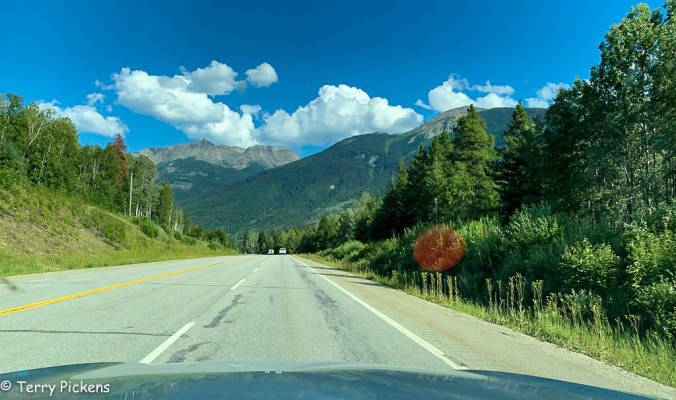
Leaving the campsite about 8am it is the final push to Jasper National Park. Stopping behind a long line of cars just minutes from the entry to the park it was discovered that a road closure was in effect from 9am till 11am. Wait it should only be 8:30am, no there was a time change yesterday that proved the undoing of this plan.

IT’S ACTUALLY 9:30

Oh well guess it’s time to climb out of the car and get some stretching done for the morning.

Jasper National Park, Alberta, Canada

Finally right at 11am the line of cars starts to move and entering the park it is time to stop at the visitors center located in the town of Jasper.

Jasper National Park is Canada’s largest National Park with 4,200 sq. miles (11,000 sq. km) that lies just north and adjacent to Banff National Park. This beautiful Park consisting of glaciers, ice fields, hot springs, lakes, waterfalls and mountains was established in 1907 as a forest park and was provided full National Park status in 1930. Part of the Canadian Rocky’s National Park along with neighbor Banff and 2 other Parks it was declared a UNESCO World Heritage Site in 1984.

The resort town of Jasper is the headquarters for Jasper National Park with it’s Visitors Center. This year round resort is with complete facilities for it’s guests, a quaint walkable downtown featuring restaurants, hotels and shopping with nearby Marmot Basin Ski Resort. The town was quite crowded with other visitors this Friday so finding a parking spot proved a little challenging. Finally getting parked it was a medium length walk to the Visitors Center to get aquatinted with the park. Moving around inside was a little claustrophobic so the goal was quickly accomplished and then it is off  into the park.

Icefields Parkway

Rated as one of the top drives in the world, Canadian Highway 93, the Ice Fields Parkway, is a 144-mile  (232km) stretch of road winding its way through 2 National Parks with a beautiful landscape rich in history traversing subalpine forests and the Columbia Icefield.

Going south on the Icefields Parkway we come to Athabasca Falls. Flowing from the glaciers of the Columbia Icefield, the Athabasca River is the largest river system in Jasper and the 75 foot (23 m) Athabasca Falls. Although not very tall, it’s power comes from the flow of the river and the narrow canyon it traverses making for a spectacular view.

In the park is the largest ice field in the Rocky Mountains of North America, the Columbia Icefield. It’s 125 sq. mile (325 sq. km) area is in both Banff National park and the adjoining Jasper National Park.

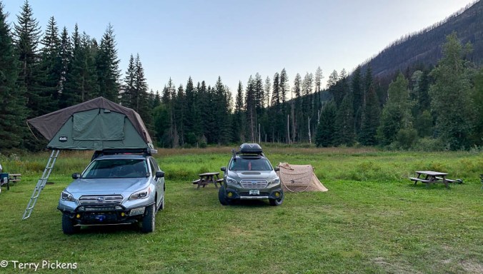
Just past the Athabasca Glacier on the Columbia Icefields is a small campsite for tents only. Pulling in there 2 spots available, so here is home for the night. 

After getting camp set up it was a short walk along the Parkway to the trail head for a 1.1 mile (1.8 k) moderately strenuous hike to the toe of the Athabasca Glacier. A fabulous walk to the base of the glacier and you can hike right onto it. If you do not feel like walking you can take a bus from the lodge to the glacier where you get onto a Tundra Bus for a drive out onto the glacier.

The next morning it was an early rise and quick breakfast to head south and hopefully get to a few places before the crowds start to gather.

Banff National Park, Alberta Canada

Established in 1885 this is Canada’s oldest national park. Located in the Canadian Rocky Mountains, Banff National Park encompasses 2,564 sq miles (6,641 sq km) of forested, alpine terrain consisting of hot springs, glaciers, ice fields, rivers and waterfalls in a subarctic ecosystem.

Bridal Veil Falls

8-9-16

Weeping Wall showcases the melt-off from the snowfields emerging form fissures in the cliff face emerging as a series of waterfalls.

8-9-26

Getting to Lake Louise it was a quick off ramp to see Moraine Lake. Well it was quite overrun with vehicles and people trying to get to the lake for the morning sunrise. It takes 45 minutes to get to the large parking lot which is overrun with cars. If the parking lot is this full the trail to the lake must be just as crowded. Turning around and getting back to the parkway it was discussed and with the final day of the trip being Sunday at Glacier NP along the popular Going to the Sun Highway it was decided to head out of the Banff early and head home as it was only a 10 hour drive. Glacier National Park is relatively close and can be left for another adventure.

Leaving the Icefields Parkway at Castle Junction it was time to head west along Highway 93 to the town of Radium Hot Springs where the highway turns south for the USA Border Crossing. Stopping in Cranbrook I pick up a quick lunch and then it’s off to the border.

It was a 45 minute wait at the border as it was quite crowded. Finally through It’s south on State 95 to Interstate 90, Highway 395 and finally onto Interstate 84 west to the coast and home.

Arriving home at about 10pm I take a quick shower to hose off the few days of grim due to no showers and fall into bed. Unpacking will be for tomorrow, sleep comes quickly as I am home in my bed after 21 days on the road.

8-10-11


Day 19 – Onward to Jasper and Banff

Getting up in the morning goes a little slow today. It has been a great adventure but many days dong so many things has left me a little tired. After having breakfast and packing up, it’s time to get on the road. Continuing along Highway 16 there is so much to see along this stretch of road from natures wonders to historic sites. I will be back to visit Fort St. James, Vanderhoof, and many of the Provincial Parks along its route.

Crossing back through British Columbia’s 9th largest city, Prince George, the route continues east for Japer and Banff National Parks along BC Route 16, The Yellowhead Highway. Traffic passing through the city is a little strange on my senses, there have been so many empty stretches of roads that all the traffic is hard to come back to. I remember going through Whitehorse, Yukon with the same feeling. So many people it seemed.

8-8-1

Stopping at the Ancient Rainforest Trail to hike on wooden walkways through an ancient forest located in one of the upper Fraser River Valley’s few remaining antique stands of western red cedar is just jaw dropping. These stands include cedar trees that are 800 – 2,000 years old in an area farther from the ocean than any other temperate rainforest in the world, it feels like being on the west coast, such as Vancouver Island. Huge cedars, all kinds of moss, skunk cabbage, wild flowers, and vibrant green ferns flood your senses. Interpretive signs along the trail explain the forests history, wild life, as well as the plant life.

Along the longer trail you can pass a beautiful 30m (98ft) waterfall named Tree Beard Falls, clusters of colossal cedars known as the Sacred Circle, a cedar called Tree Beard that towers mightily with a display of unusual arms, and then to an especially large based cedar that makes up for it’s lack of height in it’s girth. This last is named Big Tree, being 16 feet (5 m) in diameter it is the largest cedar in the Ancient Forest as it stands in silent vigil beside a fallen comrade.

These resilient inspiring ancient cedars are beautiful in their old age, although broken and falling apart in places, they continue to reproduce and contribute to the ecosystem.

It was the weekend and campgrounds were full in the area. Finally finding a place in the group camping area of Mount Robson Lodge. This open area was in a meadow with picnic tables spread around. It was a little far away from the facilities but very quiet even with all the neighbors around.

8-8-2


Day 18 – South on Highway 37 on the way to Jasper and Banff

The mornings adventure starts with a drive back into Alaska to visit the Salmon Glacier, the fifth largest glacier in Canada and the largest road-accessible glacier in the world. An approximate 16 mile (25.75 k) dirt/gravel road leads to a marvelous overlook for the glacier located just back into Canada. This glacier is one of hundreds within the Boundary Ranges. This natural hazard has Summit Lake located at the north end of the glacier and every year in summer the lake breaks an ice-dam and the water flows under the Salmon Glacier into the Salmon River. This flooding causes the river to rise approximately 4–5 ft (1.2–1.5 m) for several days. This river flows beside the town of Hyder, Alaska and empties into the Portland Bay.

Marveling in the immensity of the glacier it is time to head back through Hyder and Stewart continuing 134 miles (215.5 k) south on highways 37A and 37 to the Gitwangak Battle Hill Historic Site. This fortress  utilized a strategic location with several different defensive fortifications: rolling things such as rocks and huge logs covered with spikes down the sides of the slopes of the fortress during raids. The Gitwangak people would drop back to this location during raids on the village. The Battle Hill was never lost during battle. Walking along the trail between the parking lot and the top of the Battle Hill is quite a hike. Stairs lead down into the valley the back up the hill with its commanding views. Right before leaving 2 caretakers of the site pulled up and we discussed the importance of this site to the local First Nations Tribe. All of the people we have met on this journey have been so warm and welcoming.

3 3/4 miles (6k) further down the highway is the Gitwnagak Totem Poles set right in the village. Moved several times due to flooding these are the oldest collection of Totems found in their original village anywhere in British Columbia.  These spectacular poles are a sight to see. Luckily a local was walking and the road and spoke with us for about a half hour explaining the poles and the the people in the village. A very memorable experience I will not soon forget.

Turning east on Highway 16, The Yellowhead Highway, we drove for a little over an hour  and it was lunch time. Entering the Alpine Themed town of Smithers we decided on eating at the Alpenhorn Bistro. Why not eat in a themed town at a themed restaurant. Good food was had and off for the final drive of the day to the Shady Rest RV Park just outside of Houston, BC, Canada.

8-7-11

This RV park had a location for tents adjacent to the RV park. Showers and Laundry facilities are available and the last shower of the trip was a welcome relief. Camping for most of the trip shower and laundry facilities were a little far between which left for many sponge baths along the way. A nice quiet evening and a quick small dinner ending with a quiet nights sleep was well needed


Day 17 – Cassiar Highway and on to Jasper

The Cassiar Highway (BC Route 37) was completed in 1972 to connect the Yellowhead Highway in BC to the Alaska Highway in the Yukon. This 450-mile (742 km) road is a narrow; mostly 2-lane road that traverses some beautiful countryside. There are many side trips throughout it’s length and will be a place I come back to explore.

Left Boya Lake Provincial Park leisurely in the morning . It would just be a road trip day with several stops along the way.

First stop was at Jade City is a roadside community selling Jade products from the nearby mountains. This “spot on the road” and the region around Jade City is rich with a jade precursor called sereninite, greenstone jade look-a-like, and home to 92% of the world’s nephrite jade. As of 2015 ,Jade City’s population was about 30 people. The Cassiar Mountain Jade Store offers free RV parking, free coffee and free wifi and they also sell many jade products made from nearby formations. A reality TV series documented the mining efforts of the Cassiar Mountain Jade Store, and the Bunce family. They mine thehard rock deposits and placer deposits left by glaciers. Claudia Bunce’s father, Steve Simonovic started mining the area in 1985 and the Bunce family has continued mining the area for jade since.

It was an interesting shop with many fine jade collectables inside the shop and some very interesting old vehicles and equipment on the outside. Next to the parking lot was also a large saw they would demonstrate how the rock was cut and processed for later art work.

There are many sites to see along this beautiful road with a few being  the Dease River, Dease Lake that provides all visitor services; lodging, dining, grocery store, and fuel, Mount Edziza (a dormant volcano) and the Skeena and Cassiar Mountains, Willow and Rescue Creek Bridges which are 2 narrow wooden plank bridges along the Cassiar Highway, Iskut River overview, and Bell II Crossing, a metal grate bridge over the Bell-Irving River.

Finally reaching Meziadin Junction which is the turnoff for Stewart-Hyder Access Road (Highway 37A) providing access to the towns of Stewart, BC, Canada and Hyder, Alaska. .  In the area you can visit the Bear and Salmon Glaciers.

338 miles (544 k) from Boya Lake, the camp for the night was at Bear River RV Park in Stewart, BC, Canada. A full service site with RV and tent areas, restrooms, showers and laundry facilities. Laundry was again needed as it had been a few days and this would be the last of these services needed on the adventure. A very quiet place with friendly staff and campers. Stewart is a small town of about 494 individuals located at the head of the Portland Canal in northwest British Columbia. Start is 2 mile (3 k) west of Hyder, Alaska.

Being late in the day it was off to find a nice dinner and it was recommended by a few travelers along the way to stop at a place in Hyder, Alaska named The Bus. The seafood sounded great although it was crowded and being that it was just a husband and wife establishment they were not taking any more orders that day. It was decided to eat at The Glacier Inn that provided good food but the taste buds were really geared up for a meal at The Bus.

If libertarians had an earthly paradise, it would probably be here in Hyder. Separated from American governments and bureaucracies by immense wilderness, Hyder has no property taxes or police, and citizens can carry firearms openly. Yet the village, wedged between two Canadian borders, has long relied on neighboring Stewart, British Columbia, for groceries, electricity and other services.

Heading back into Canada and the campsite, the evening was spent doing laundry showering and reorganizing the vehicle. Tomorrow it will be heading back into Alaska to see the Salmon Glacier and then retracing the route back to make the way south along Highway 37 to Highway 16 , The Yellowhead Highway and to Jasper National Park.


Part 16 – Leaving Skagway

Hard to believe it is only 52 miles (83 km) from Skagway to the Customs house and a return to the Yukon and Canada and only 65 miles (105 km) from Skagway to the turn at Jakes Corner, to head west for the Alaskan Highway and continue the trek home.

It was a long lovely drive along Highway 2 (The Lower Klondike Highway),

Turning northwest at Carcross, Yukon on Highway 8 takes you to Jakes Corner, then it was a turn west along Highway 1 (The Alaskan Highway),

Reaching Highway 37 (The Stewart / Cassiar Highway) it was a southern turn,

8-5-2

And finally to the campsite for the night at Boya Lake Provincial Park, 361 miles from Skagway. The campsites were very small so we had to find 2 campsites for the night. Luckily there were 2 that shared a driveway and they were located right across the drive from the lake.

It was a peaceful evening to rest for the next push to Stewart, British Columbia, Canada / Hyder, Alaska in the morning.


Day 13 – Whitehorse, Yukon, Canada and onward to Skagway, Alaska

Whitehorse was only about an hour away from the campsite so a relaxing morning sleeping in an extra half hour and a leisurely breakfast awaited.

After packing up we talked to a wonderful couple from Whitehorse who come here to camp, boat and fish on their days off. After talking for probably an hour and a half and getting recommendations for Whitehorse and the afternoon trip  it was on to Whitehorse.

Whitehorse, Yukon has been the capitol city of the Yukon since 1953 and is the northern terminus of the White Pass & Yukon RR from Skagway, Alaska which ferried prospectors to the riverboats plying the Yukon River to the northern goldfields surrounding Dawson in 1900.

Whitehorse’s second boom time was during the construction of the AL-Can Highway in 1942 when many workers converged on this small town. Construction worker population grew form 2,500 to 3,800 with 1,800 tons of materials and equipment being shipped by rail from Skagway each week in 1943.

This, the only city of the Yukon Territories, has a population was 33,897 people per the 20111 census. A pleasant place to visit as it provides all the services of any town or city. Many attractions and good food establishments are here for the visitor to enjoy.

Parking at the Visitor Center downtown it was off to a recommended spot for lunch, Klondike Rib and Salmon BBQ. Such a fun atmosphere to enjoy as was the wonderful meal. I will definitely go back there for another meal to try out a different menu item, mine was fantastic and very filling.

8-2-1

Heading back to the Visitor Center to gather some information on the area it was time to visit a real Sternwheeler, the S.S. Klondike that sailed the Yukon River between Whitehorse and Dawson City.

8-2-2

The S.S. Klondike National Historic Site is an old stern-wheeler that once plied the Yukon River carrying passengers, mail and supplies to Dawson City. With only a four and half month shipping season the boats were hauled out of the water on skids in the Whitehorse Ship Yards for the winter months of a frozen Yukon River. This interesting attraction lets you board the ship and on a self guided tour to explore the many areas of its interior at your pace.

Built in 1929 this boat was the largest on the Yukon. Sternwheelers were less vulnerable to paddle damage than the side-wheelers. Built in 1929 an accident sunk her in 1936. Refitted that winter the Klondike went from an ore hauler to carrying passengers and cargo. She carried 300 tons (270 tonnes) of cargo with a draft of only 40 inches (1 meter) and 32 – 1st class passengers.

The lower deck just above water line was for the crews quarters, the cargo, engine room, boilers and with bunks lashed to the sanctions at the aft sleeping accommodations for 2nd class passengers. The next deck held the 1st class cabins, Dining Room for the passengers and a separate one for the crew, Kitchen, Observation Lounge at the front of the ship and the Sun Deck at the stern. Above that was the Boat Deck housing the Officers Cabins. Finally at the very top was the Wheelhouse or “Monkey Island”. Situated well forward and high it gave an unobstructed view for the Master and Pilot to navigate the ship though the dangerous waters.

Next up it was a drive to the outskirts of town to visit Miles Canyon. The canyon is a cross section of volcanic rocks where the Yukon River cuts through a succession of flows south of  Whitehorse. The White Horse Rapids in Miles Canyon provided a significant challenge to the prospectors heading to theDawson City and the gold rush providing the upstream terminus of the Paddle wheelers. The rapids are now tamed by dams along the river.

Finally it was off the Yukon Beringia Interpretive Center that explains the Yukon’s history during the Ice Age. Being largely ice-free during this timea local cave provided the oldest evidence of human habitation in North America has been found.

Getting a late start the following attractions were missed but sound fun and interesting making for another visit an enjoyable adventure.

The MacBride Museum houses artifacts and stories of the events and people who settled and built the Yukon.

Waterfront Walkway provides a walking path along the Yukon River connecting several parks along its path.

Yukon transportation Museum is home to the world’s largest weathervane, an old DC-3 and provides exhibits on the transportation used in the far north.

Old Log Church Museum is one of the oldest buildings in the city completed in 1900 and hides stories of the older pioneers of the region.

Yukon’s oldest brewery north of the 60th parallel, the Yukon Brewing Company.

Leaving Whitehorse late in the afternoon the route turned south on the South Klondike Highway to its terminus in Skagway, Alaska. This relatively short 2.5 hour drive of 105 miles (169 k) was a breathtaking day of travel. This 2-lane road of spectacular scenery had many turnouts for viewing vast landscapes and intimate waterfalls. Before the highest point of the road at 3,292 feet (1,003 m) at Whitehorse Pass there is an 11. 5 mile (18.5 k) 11 percent grade of roadway.

Turning west right before entering Skagway along the Dyea Road, Dyea Campsite was the location for the next 3 nights of the journey for 2 full days to explore Skagway, Old Town Dyea and the Chilkoot Trail.

8-2-18

Day 12 – Steamboat graveyard and south on the Klondike Highway toward Whitehorse.

It was agreed that we should again reroute due to incoming harsh weather and the ferry strike going on The Marine Highway. The original route was to go across the ferry at Dawson City and follow the Top of the World Highway and the Taylor Highway to Tok, Alaska. Go south along the Alaska Highway along the Haines Highway to Haines, Alaska and take the ferry to Skagway. With the ferry strike it was decided to go south to Whitehorse, Yukon, Canada and directly to Skagway, Alaska via the South Klondike Highway.

Waking up early we drove into town and ate breakfast at Belinda’s Restaurant for some good ole pancakes and eggs.

After breakfast we parked along Front Street and walked to the ferry crossing of the Yukon River and crossed to walk to the Sternwheeler Graveyard located past the campground on the west side of the river. Tucked into the trees you will find the wooden remains of seven paddlewheelers. Once the primary mode of transportation in the region, these were abandoned when other transportation options became more popular.


Scuttled off the side of the river this graveyard hulking remains of wooden paddlewheel ships are broken and damage hulks that looks as though they were crashed onto shore. Most of the wrecks have collapsed but a few of the ships are still intact enough to explore, and many of the paddlewheels remain thanks to their metal skeletons.

After this interesting exploration of the ships it was time to walk back and head south toward Whitehorse. An interesting trip we are now doing in reverse from a few days ago on the way to The Dempster Highway.


Arriving back in Carmaks it was time to stop for gas and pickup a few things at the adjacent store. After shopping it was time for a quick lunch in the parking lot before continuing on to the destination for the night, Lake Leberge.


Lake Laberge is a widening of the Yukon River north of Whitrehorse. At 31 miles (50 k) long and from 1.25 to 3 miles (2 to 5 k) wide its water is always very cold, and its weather often harsh and variable. Its English name comes from 1870 commemorating the first French-Canadian to explore the Yukon in 1866, Michel LaBerge. During the late 19th and early 20th centuries winter sternwheelers carrying goods early in the shipping season on Lake Laberge regarded the lake as trouble, as it was one of the last areas of the river to thaw of ice.


Entering the campground it was signed as full but we continued around to see if there might be an empty campsite and to see the lake. Luckily a husband and wife were packing up to leave and asked if we wanted the campsite. We said thank you yes and waited 20 minutes as they packed up. What a wonderful camping spot, very close to the lake with a beautiful view from the site. Now for a nice dinner and to sit by the lakeshore and enjoy the scenery with peace and quiet.


Sa far this trip has just been outstanding and I suspected it would continue on this way.


Day 11 – Dawson City

Close to 100,000 prospectors set off over the Chilkoot Trail in Dyea/Skagway, Alaska on foot then sailed up the Yukon River to find their wealth in the gold fields surrounding Dawson City, Yukon. With a population of only about 1,900 residents this National Historic Site and UNESCO nominated town has many restored buildings and sites to explore. A few of the places to explore and enjoy a trip back in time are a walking Tour of town, the Palace Grand Theater, the Jack London Museum, Diamond Tooth Gertie’s to join the Sourtoe Cocktail Club by having a shot with an actual toe in it at the Sourdough Saloon in the Downtown Hotel (the toe must touch your lips), see the SS Keno the last steamer to run the Yukon River, discover the areas history at the Dawson City Museum and just outside of town explore the grand old Dredge #4, Discovery Claim National Historic Site and the steamship graveyard.

7-31-17

First up for a bit of vehicle maintenance, the vehicles needed a complete cleaning with all the mud buildup from the drive yesterday. It took about 30 minutes each to get most of the dirt removed from the outside.

After the cleanup it was over to Dredge #4 to investigate. A guided tour is available to explore the inside of the dredge. An interesting informative tour is provided but it is not inexpensive, although I felt well worth the cost.

7-31-1

Dredge No. 4 mined gold from 1913 to 1959. This wooden-hulled bucketline sluce dredge  is now located along Bonanza Creek Road about 8 miles (13 k) south of Dawson City along Upper Bonanza Creek road. This the largest wooden-hulled dredge in North America was designated a National Historic Site on 22 September 1997.

Designed by the Marion Steam Shovel Company it was hauled in pieces to Dawson City at a cost of $134,800 for shipping which was then built by the Canadian Klondike Mining Company on site at Claim 112 near Ogilvie Bridge, the current location of the bridge over the river along the Klondike Highway to Dawson City. It moved to its current location along Bonanza Creek by digging a path and filling in the area behind itself in its own pond.

Excavating gravel at 22 buckets per minute with 72 large buckets that processed 18,000 cubic yards (14,000 m3) of material per day. In use from late April or early May until late November each year, and sometimes throughout winter, it captured nine tons of gold during its operation.

Continuing along the dirt road we made a stop at the Discovery Claim National Historic Site where gold was first discovered in the area for a short walk around the displays explaining the mining operations of the area.

Stopping by a small tourist stop with a souvenir shop, old buildings and quite a lot of old mining equipment I explored the old buildings and equipment having a fun time with my camera.

Back in town I dropped the car off at the hotel and wandered the rest of the afternoon and evening around the streets, shops and museums of Dawson City. First up was the Dawson City Visitors Center to look around the exhibits and get an idea for a much needed very late lunch. Leaving there with several ideas I strolled across the street to the NWT Dempster Highway Visitor Center to see what was missed during the previous few days. This would be a good stop if you are going up the Highway after your visit here in Dawson City.

After talking to the very nice informative person working there I continue my wandering to the Triple J Hotel and restaurant for my late lunch. I had the tasty Wild Salmon Burger with a caper aioli and an iced tea. Sitting on the outside porch I enjoyed my meal watching the activity happening on the street it was a very good relaxing meal.

7-31-44

I sat on the porch on the left for lunch. What a wonderful place to have lunch.

After lunch I continue on to the Dawson City Museum where I explore the exhibits on 2 floors of the old Territorial Administration Building discovering the natural history of the Klondike Gold Fields through exhibits, displays, dioramas and informative shows. You explore the history of Yukon’s First Peoples and early explorers. Experience the Gold Rush through the stampeders and entrepreneurs, and the visionaries. I was fortunate enough to see a live demonstration of a sluce shaker box in action and how gold was recovered from the river and stream beds.

7-31-45

Walking to the outskirts of town I visit the Robert Service Cabin. Service was a British born poet referred to as the “the Bard of the Yukon”. He was one of the most successful poets of the Twentieth Century. who arrived in the Yukon as a bank clerk turning vivid tales, told to him by veterans of the great gold rush, into classic poems. Robert Service arrived in Dawson City in 1908 continuing  to write about his northern adventures until his departure from Dawson, and the Yukon, in 1912. Sadly the cabin was closed for the day so I couldn’t get a glimpse inside to see how this gentleman lived.

7-31-19

Just down the street was Jack London Museum and Cabin. This museum and cabin shows the time Jack London spent a year in the Klondike. Trying his hand at mining he still spent most of his time writing stories that would make him a well known author. It again was closed due to the late time I had passed there.

Just west is a pedestrian-bicycle trail along the Klondike and Yukon rivers that I followed back to my tent cabin  for the evening. Stopping at the store for a few items I continue to the cabin to shower, due some laundry and relax for the evening. Another travel day in the morning so must rest up.

It was amazing that just before the grocery store I noticed a large European based adventure RV turning into a parking lot. I had to get a closer look and hopefully talk to its drivers. I met a wonderful couple, he from Luxembourg, a small European country surrounded by Belgium, France and Germany and his wife from France. I talked with them for about an hour listening to their adventure so far and where they are going on their long trip.

As a side note, they stopped by my house when I returned from the adventure for dinner and the stayed the night on their trek to Mexico and Central America. I wish them well on their journey.

Days 10 – Returning to Dawson City

Returning south along the Dempster it is decided to continue all the way from Inuvik to Dawson City in one day. The weather has turned bad this day and under a constant sometimes heavy rain it was decided to push on.

Reaching Eagle Plains for the required fuel stop we head over to the small restaurant to pick up a quick bite to eat. A group of travelers from Australia are enjoying their meal and we talk to the for about a half hour before leaving them as they head north.

The closer we got to the Klondike Hwy the weather was changing for the better. We continued on as it was not that far to Dawson City at that point.

Upon reaching the Klondike Hwy, Canada 2, it is time to head west for Dawson City, Yukon Territories.

7-30-7

It was 7:30 by the time we arrived in Dawson City and being very hungry, stopped at Sourdough Joe’s for a bite to eat. I had a burger with bacon, cheese, chili, an egg and a small salad. DELICIOUS.

7-30-9

Sourdough Joes Burger

We start the search for a place to spend 2 nights here and decide to splurge on a room. All the places we checked were fully booked but luckily one manager called around to other locations for available rooms. It was discovered an establishment named The White House had 2 tent cabins available for the 2 nights we planned on staying. Driving the short 1/2 mile there we look at the rooms and decide this is the perfect place to wind down after the adventure north we just had. Renting the 2 tent cabins with mine having a queen bed, a single bed, lounge sofa, small dining table and kitchen utensils for heating water for tea/coffee.. This was no ordinary canvas tent accommodation, it was provided with a wooden floor and door, covered porch and a hard translucent roof covering, shared bathroom and shower and a small outdoor kitchen/dining area to prepare food, this was a perfect place to enjoy 2 nights of glamping comfort.

Day 9 – The final push north to Tuktoyaktuk, Northwest Territories and the Arctic Ocean.

Named the Inuvik-Tuktoyaktuk Highway (ITH) the road begins at the end of the Dempster Highway in Inuvik, Northwest Territories and continues for 138 kilometres (86 mi) north towards Tuktoyaktuk, a coastal community on the Arctic Ocean. With its eight bridges this two-lane gravel road was opened on April 29, 2017. The Inuvik to Tuktoyaktuk ice road closed for the last time and now all vehicle traffic is via the new all-weather road.

Map 4

The idea of an all-season highway from Inuvik to Tuktoyaktuk was first brought up in the 1960s. In 1974 the Public Works of Canada completed a survey and technical study of a 140 km (87 mi) route between the towns. The local First Nations people completed their environmental review of the highway in January 2013 and granted their approval. In March 2013 the territorial legislature approved funds for construction of the all-weather highway.

Construction began in January 2014, and was completed with one crew working from Inuvik and a second working from Tuktoyaktuk.  The highway opened on November 15, 2017 and includes eight bridges and 359 culverts.

Tuktoyaktuk-A

Tuktoyaktuk is a hamlet of about 898 people settled in 1928. This natural harbor has been used for centuries by the Inuvialuit as a place to harvest caribou and beluga whales. There are not many tourist facilities in Tuktoyaktuk, a few rooms, a small camping area, grocery store, gas station, visitor center, and food establishments. There are numerous individuals giving tours and lectures on the local culture and landscape. Still finding it’s own with the new influx of visitors due to the new all season highway it is a remote outpost that is a destination you should not miss.

Such a magnificent Highway. The views are stunning that go on forever.

This slideshow requires JavaScript.

Video by H. Berge

Entering the town of Tuktoyaktuk it was such a small hamlet.

Finally I dip my feet into the Arctic Ocean, the furthest point north I have been in my life. A life long goal of mine has been to dip my feet into the Arctic Ocean. A goal finally achieved.

An example of the native building is available for viewing and has scheduled tours available from the visitor center. There are 2 structures at the site, one a house without its finish showing how it was constructed and the other a finished structure. To get into the finished structure you must take a scheduled tour.

Tuktoyaktuk is a special place for it has one of the highest concentrations of pingos, with some 1,350 examples.

What is a Pingo? it is a mound of earth covered ice located only in Arctic regions formed by hydrostatic pressure in a permafrost environment.

After eating a great lunch at Grandma’s Kitchen we started our way back to Inuvik and our campsite for the night.