Day 9 – The final push north to Tuktoyaktuk, Northwest Territories and the Arctic Ocean.

Named the Inuvik-Tuktoyaktuk Highway (ITH) the road begins at the end of the Dempster Highway in Inuvik, Northwest Territories and continues for 138 kilometres (86 mi) north towards Tuktoyaktuk, a coastal community on the Arctic Ocean. With its eight bridges this two-lane gravel road was opened on April 29, 2017. The Inuvik to Tuktoyaktuk ice road closed for the last time and now all vehicle traffic is via the new all-weather road.

Map 4

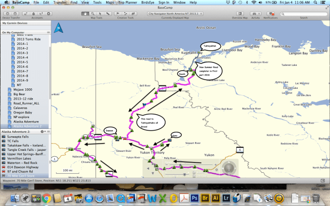
The idea of an all-season highway from Inuvik to Tuktoyaktuk was first brought up in the 1960s. In 1974 the Public Works of Canada completed a survey and technical study of a 140 km (87 mi) route between the towns. The local First Nations people completed their environmental review of the highway in January 2013 and granted their approval. In March 2013 the territorial legislature approved funds for construction of the all-weather highway.

Construction began in January 2014, and was completed with one crew working from Inuvik and a second working from Tuktoyaktuk.  The highway opened on November 15, 2017 and includes eight bridges and 359 culverts.

Tuktoyaktuk-A

Tuktoyaktuk is a hamlet of about 898 people settled in 1928. This natural harbor has been used for centuries by the Inuvialuit as a place to harvest caribou and beluga whales. There are not many tourist facilities in Tuktoyaktuk, a few rooms, a small camping area, grocery store, gas station, visitor center, and food establishments. There are numerous individuals giving tours and lectures on the local culture and landscape. Still finding it’s own with the new influx of visitors due to the new all season highway it is a remote outpost that is a destination you should not miss.

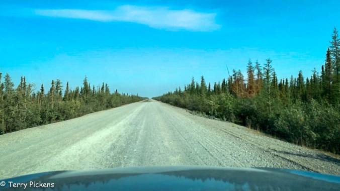
Such a magnificent Highway. The views are stunning that go on forever.

This slideshow requires JavaScript.

Video by H. Berge

Entering the town of Tuktoyaktuk it was such a small hamlet.

Finally I dip my feet into the Arctic Ocean, the furthest point north I have been in my life. A life long goal of mine has been to dip my feet into the Arctic Ocean. A goal finally achieved.

An example of the native building is available for viewing and has scheduled tours available from the visitor center. There are 2 structures at the site, one a house without its finish showing how it was constructed and the other a finished structure. To get into the finished structure you must take a scheduled tour.

Tuktoyaktuk is a special place for it has one of the highest concentrations of pingos, with some 1,350 examples.

What is a Pingo? it is a mound of earth covered ice located only in Arctic regions formed by hydrostatic pressure in a permafrost environment.

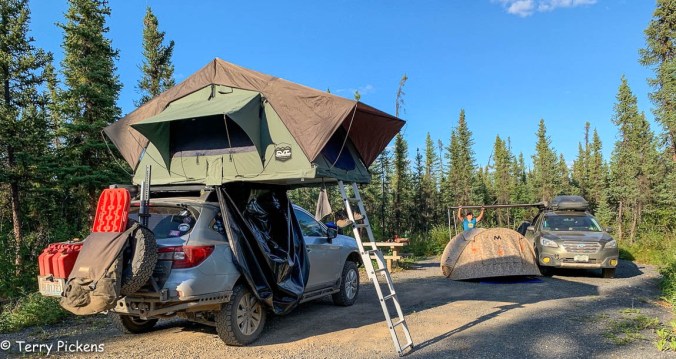
After eating a great lunch at Grandma’s Kitchen we started our way back to Inuvik and our campsite for the night.


Day 8 – A short drive to Inuvik, Northwest Territories, Canada

Not in a hurry to leave as it was only a 3 1/2 hour drive to our next destination, Inuvik, it was time for a nice breakfast and to visit with 2 other travelers on the road north. Leaving about 10:30 we passed through Fort McPherson again and marveled at the natural beauty surrounding this road.

In a short 41 miles (66 k) you arrive at the ferry crossing of the Mackenzie River (Tsiigehnjik,. a river named a Canadian Heritage River in 1993. This ferry actually has 3 stops on its sailing, the southern route of the Dempster, northern route of the Dempster and the small town of Tsiigehnjik. This town has no roads built to it due to the river and permafrost conditions of the area.

Stopping 23 miles before Inuvik we visit Titheqehchii Vitail Lookout trail head for a short 10 minute walk to a beautiful over look of Cambell Lake.

7-28-18

Arriving in the town of Inuvik (The Place of Man) the entire town is constructed on permafrost. Population is at 3,243 as of 2016 this small planned village has unique utildor corridors carry all the water, sewage and heating systems between the buildings. This is also the first Canadian town built north of the Arctic Circle that provides normal city services to its residents. Inuvik has 2 gas stations, repair shops, lodgings, campgrounds, restaurants, fast food, groceries, and clothing stores. This was the farthest north a year round road reached until the current road to Tuktoyaktuk was built and opened last year, all access to Tuktoyaktuk was by plane or the Winter Road.

Setting up camping at Happy Valley Territorial Park right in town was within walking distance was a wonderful place to eat, the grocery store and the Visitor Center. The campground has toilets, showers (free) and laundry facilities (at an extra cost) available. The tent platforms were welcomed.

Walking across the street it was time for a late lunch, early dinner at Alestine’s, a converted bus that filled the tummy.

Continuing the walk it was to the grocery store to see what was available, this store is not just a grocery store but an outdoor equipment shop as well. Then off for the visitor center across town, we were disappointed to learn it was closed for a couple of hours for lunch. Heading back to the grocery store to pick a few items up it was back to camp for laundry, showers and relaxing before our day trip tomorrow to Tuktoyaktuk and the Arctic Ocean, 86 miles (138 k) north along Highway 10 The Inuvik-Tuk Highway (ITH).

Day 7 – Up the Dempster to the Arctic Ocean and Tuktoyaktuk

From the junction of the Klondike and Dempster Highways, it’s 456 miles (734 km) to Inuvik, North West Territories and then an additional 86 miles (138 km) north to Tuktoyaktuk, North West Territories beside the Arctic Ocean.

The Dempster Highway is only paved for the first 5 miles (8 km) from the Klondike Highway and the last 6 miles (10 km) into Inuvik. The road is open year round but it is a hard road on vehicles and tires, its gravel surface has sudden changes, potholes, becomes boggy and slick in wet weather and is made of crushed shale, which is very damaging to tires. You will need to use 2 free ferries on your drive to Inuvik. Calcium Chloride is used to stabilize the road during wet conditions so it’s advisable to clean the vehicle as soon as you can after traversing this road.

Woke up the next morning and there was a light rain falling. It lasted for a few hours in the morning then cleared up.

Making our way up the Dempster we pass Engineer Creek Yukon Government Campground at mile 120 (193.8 k) where it was decided a short break was needed. We drive around the loop of campsites to explore the possibility of this being a stop on the way south. It was fortunate that we went through as I noticed a gentleman’s vehicle I knew from Instagram that was also making the trip north. He had already been to Tuktoyaktuk and was making his way south. Stopped for about 30 minutes exchanging tales of our adventures so far. The campground is full and very quiet although quite soggy from the rain and has many mosquitoes swarming about, no doubt from the rain. This was an area with he most mosquitoes experienced on the trip.

You must go all the way to Eagle Plains for gas, food, and lodging. This small outpost is located 229 miles (369 k) form the the gas station at the intersection with the Klondike Highway. Remember to fill up with gas when available along the Dempster, there might be long distances between services.

At 252 miles (405.5 km) from the Junction with the Klondike Highway you arrive at the Arctic Circle.

At 289 miles (465 km) you pass into the Northwest Territories. This Territory has approximately 519,734 sq mi (1,346,106 km2 ) with a population of only 44,420 residents (estimate for 2019).

Just a short distance takes you to the first ferry crossing at the Peel River. We are the only vehicles on this northern crossing of the ferry.

Video by H. Berge

Video by H. Berge

One mile past the ferry crossing we arrive at our camp for the night, Nitainlai Interpretive Center and Territorial Park Campground. The center has very nice exhibits and displays of the Gwich’in culture. The adjacent campground has water, firewood, toilets and wonderful warm showers. It is a nice respite after a days driving.

7-27-25

Before settling down for the evening gasoline is required in the vehicles and as tomorrow is Sunday the stations won’t be open till about noon. It is a short drive north into Fort McPherson, a town of a population of approximately 791 people with a Café, 2 grocery stores, 2 gas/diesel stations and an 8-room hotel 342 miles (465 k) along the highway.


Canada / Alaska Adventure in July-August

All right my trip is getting closer and I’m in the final stages of preparation. Vehicle is ready just needs final fluid changes before leaving. Camping gear is waiting. GPS route is set and just the final tweaks and additions are being done.

2018 Tillamook

Will be leaving Southern California on July 9th heading to Vancouver, WA along Highway 395 for the birth of my 4th grandchild. Leaving Vancouver I will head to Glacier National Park, Banff and Jasper National Parks in Canada then start the northern push to Dawson Creek, B.C. and start the drive there at Mile-marker Zero on the Alaskan Highway (Al-Can to us older folks) to Watson Lake, Yukon.

Turning off the Alaskan Highway at Watson Lake I’ll be on Canadian 4, a gravel road, to make my swing to Dawson, Yukon and the Arctic ocean at Tuktoyaktuk, Northwest Territories. At this, my furthest point north, I start my swing back to Dawson and turn west to continue along the Top of the World Highway to Tok, Alaska.

Leaving Tok I will go south on the Alaskan Highway to Haines Junction and continue to Haines, Alaska along the Haines Highway to ferry across to Skagway and head back to the Alaskan Highway along the South Klondike Highway. I will leave the Alaskan Highway just before Watson Lake and turn south onto Canadian 37, The Cassier Highway, to Prince George, BC. From there I will continue south along Canadian 97 making my way back to the border and return to Vancouver, WA to visit my new grandchild before returning home south along Highway 101.

I have found during research a great resource for the area called, “The Milepost”. this details the Alaskan Highway and side-routes in Alaska, British Columbia, the Yukona nd Northwest Territories. I also picked up a camping guide named “Traveler’s Guide to Alaskan Camping” that includes all the Alaskan Highway and the same side-routes in it’s pages. Although this book was written for RV’s in mind it is good source for me, tent camping, to hit some campgrounds with services such as WIFI, showers, and laundry facilities along the way. It ranges from private, to Provincial Parks, to free camping areas along the roads.

milepost-book.jpg