Hard to believe it is only 52 miles (83 km) from Skagway to the Customs house and a return to the Yukon and Canada and only 65 miles (105 km) from Skagway to the turn at Jakes Corner, to head west for the Alaskan Highway and continue the trek home.
It was a long lovely drive along Highway 2 (The Lower Klondike Highway),
Turning northwest at Carcross, Yukon on Highway 8 takes you to Jakes Corner, then it was a turn west along Highway 1 (The Alaskan Highway),
Reaching Highway 37 (The Stewart / Cassiar Highway) it was a southern turn,
And finally to the campsite for the night at Boya Lake Provincial Park, 361 miles from Skagway. The campsites were very small so we had to find 2 campsites for the night. Luckily there were 2 that shared a driveway and they were located right across the drive from the lake.
It was a peaceful evening to rest for the next push to Stewart, British Columbia, Canada / Hyder, Alaska in the morning.
Leaving the Northern Rockies Lodge we continuing traveling on the Alaska Highway heading toward the Yukon Territory.
Lower Liard Bridge built in 1943 is a 1,143-foot (348 m) long suspension bridge is the last remaining suspension bridge along the Highway.
Liard River Hot Springs Provincial Park is a day use area with some camping. A short hike leads back into the Hot Springs Pool and has been a favorite stop along the highway to soak away those long days of driving. Passing through Liard River Hot Springs there are buffalo all over the road. It was like I was transported to Yellowstone National Park where I was stuck in a Buffalo traffic jamb. The buffalo here stuck to the shoulder of the road not creating a problem for traffic.
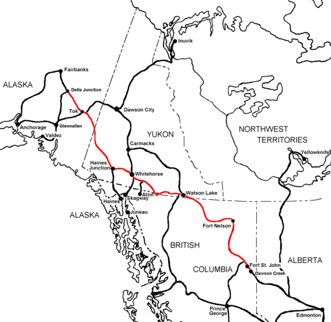
The Alaska Highway travels east and west for a portion of the route today so you pass into and back out of the Yukon Territory for a few miles until you enter it for good about the 7.5 miles (12 k) before the town of Watson Lake.
Next stop was Watson Lake, a town 612 miles (980 km) along the Alaska Highway is best known for the few acres of the offbeat at the Sign Post Forest. Designated in 2013 as a Yukon Historic Site, was started by Carl Lindley by adding a sign at this location pointing to his hometown with the mileage. Other G.I.’s added more signs to the post for their hometowns. started this collection of signs and license plates from all over the world during the construction of the AL-CAN. Numbering about over 80,000 signs travelers are still adding to this collection. Right behind is the Alaska Highway Interpretive Center, which has a video on Yukon history with photos and displays of the construction of the AL-CAN. This was town was important during the construction due to the airport and being one of the major refueling stops of the Northwest Staging Route.
Turning north along Canada Highway 4, The Campbell Highway, a 362-mile (5983 km) paved but mostly gravel road will lead to Highway 2.
Named after the first white man to explore the Yukon area, John Campbell, this all season road leads from Watson Lake to just north of Carmacks on Klondike Highway (2). This rougher road is shorter in mileage than continuing along to the junction of the Alaskan Highway and the Klondike Highway but it is much slower. Services are few and far between along this highway.
At Ross River, a supply and communications base for prospectors in the area that is now a jumping off point for hunters and canoeists, it was decided to stopper the evening at Lapie River Campground. Setting ups camp we took the short walk down too the river to enjoy the sounds.
Waking up the next morning there was a light rain dropping on the tent. Packing up quickly and having a quick breakfast we cross the Kiskatinaw Bridge and link back up with the Alaska Highway a little further north from where we left it last night.
Here are some sights that are located along the drive today. Medium to heavy rain meant we continued on praying that it would stop for the evening camping.
H. Maclean Rotary RV Park at Charlie Lake has a memorial for 12 soldiers that drowned in May of 1942 when their pontoon boat sank transporting equipment to the job site on the opposite bank of the river.
The treacherous Suicide Hill was a grade that welcomed travelers with a signpost reading “PREPARE TO MEET THY MAKER”. Guess you had to have a sense of humor if you were traveling up here in the early years. The Highway now bypasses this hill.
Suicide Hill
Sikanni Chief River Bridge was the first permanent structure completed along the highway. Built by African American army engineers it was destroyed by an arson fire in 1992. Only the original pilings are remaining.
The southern end of the Trutch Mountain Bypass is at Historic Milepost 191. This section of the Highway was bypassed in 1987 with a new road eliminating a steep mountainous winding drive. The original roadbed is a gravel road still in use by gas and oil patch crews.
Fort Nelson 283 miles (454.3 km) north of Dawson Creek is another town offering lodging, services, campgrounds and a few attractions. Originally based on the fur trade, the town was built in 1865 along the Fort Nelson River’s west bank after the second town was destroyed by fire after the local aboriginals killed the 8 inhabitants in 1813. A upward growing population in the 1940’s and 1950’s got the town recognized as an Improvement District in 1957 and finally a village status in 1987. Mile zero to clearing crews of the AL-CAN, this town is where the first clearing crews started work along the AL-CAN as a winter road already existed between Dawson Creek and Fort Nelson.
Arriving in Fort Nelson it was still raining pretty good so went into the Visitor Center for a break from the drive and to discuss the plans for the night. This is a very nice Visitor Center with a great information desk, a souvenir shop, visitor information brochures, a short movie on the area and a large sitting area for resting. Going onto WiFi it was shown by weather apps that the rain will not subside anytime soon and is scheduled to be pretty heavy at times.
Searching the road ahead it was determined to try and get a place to stay along Muncho Lake at The Northern Rockies Lodge. This is a nice lodge but a little expensive. Oh well, this might be the last time for a room and shower for awhile and the rain was coming down pretty good.
Asking the information desk on a nice place to have a late lunch it was recommended to try a restaurant just down the street. The Gourmet Girl is a small establishment that serves very good food in a quaint atmosphere.
Veering west for 200 miles (322 km) the Highway enters a dense forested area with distant wilderness vistas of 100 miles (161 km) or more.
Gardner Creek is named for local trapper Archie Gardner who helped recon this part of the AL-CAN. He is remembered in Earl Browns book “Alcan Trailblazers” by Harry Spiegal as “An old trapper….who has lived up here all his life, is the wrangler and is in charge of the string. He wears homemade moose-hide beaded moccasins; Kentucky-jean pants [and] a big beaten slouch hat. A hank of grey hair protrudes from his old hat and half covers his eyes. He sports a half growth of stubby grey whiskers and smokes a crooked, big bowl, sweet smelling pipe…..Archie is 62 years old and even though quite thin and weather beaten, he is as straight as a spruce tree and as nimble as a boy in his teens…..Archie knows this country like a book and I’m sure his knowledge of this terrain is going to be very helpful for our work.”
A required stop along the Highway is Testa River Lodge, Services and Campground for some world famous cinnamon buns. This is a very nice location with small souvenir shop, campground with showers and laundry, and a nice outside covered sitting area to rest.
Testa River Lodge
Testa River Lodge cinnamon Bun
At Historic Milepost 392 is the highest pass on the highway at 4,250-feet (1,295 m).
Another reroute of the original Highway is at Muncho Lake. The original highway is far above the lake on the mountaintop and required considerable excavation by the crews. It was relocated to a benched terrace right above the lake; hikers and mountain bikers now use the original road.
Arriving at the nights destination, Northern Rockies Lodge, it is a lovely place. This historic highway lodge is open year round providing accommodations, a full service restaurant, gas, seasonal camping and a flying service.
A road that was proposed for years became a military necessity due to the attack on Pearl Harbor. It is a road that has been dubbed “a significant feat of time critical engineering and construction” by The American Society of Civil Engineers. In 1995 it was awarded the Historic Civil Engineering Landmark Status” and is a 20th century engineering achievement.
Viewed with by congress as an urgent matte, it was February 11, 1942 that a Special Committee and President Roosevelt authorized the construction of a joint United States/Canadian effort to build the road north. During it’s construction the Japanese also invaded Attu and Kiska Islands in the Pacific adding to the urgency to protect this state of America and the Pacific shipping lanes.
Even though it was only a dirt/gravel path through the wilderness during the war this historic road was needed as a vital military route to provide supplies, troops and equipment safely to Alaska. An engineering feat to get this 1,390 mile (2,237 km) road completed in such a short amount of time, not just because of it’s length but also for the terrain and environmental restrictions placed by the regions it traversed; then finally that Canada was deeded the access road after the war to gain access into it’s remote northwestern region that was difficult to access at the time.
Construction of the AL/CAN (Alaska-Canadian Highway) officially began on March 9, 1942 with a mobilization of men from the United States. Work along the route was to be provided by American troops and individuals. The Canadian Government provided the right of way through Canada, waived import duties, sales tax, income tax, immigration and provided construction materials along the route. After the war the portion of the highway in Canada was to be turned over to the Canadian Government. America would provide all the manpower and equipment to build this road through the wilderness.
During construction there were numerous rivers to cross. At the time of original construction there were a total of 133 bridges along its route, 64 were more than 100 feet (30.5 m) in length. Pontoon bridges were first constructed to continue work on the road while a timber truss or timber trestle bridge was being constructed. These timber bridges were no match for the winters and the water flows of these untamed waters, so 99 of the 133 bridges were replaced with steel truss bridges, steel I-beam bridges, plate girder bridges, suspension bridges, and reinforced concrete bridges.
More than 10,000 American troops poured into Canada to locate, survey and construct this path north. No formal roads existed north of Dawson Creek, B.C. so the army was instructed to push north from that railhead.
Following winter roads, summer pack trails and winter trap lines a route was surveyed by using local information about the makeup of the topography. With skimpy rations and harsh conditions these individuals completed the road on October 25, 1942 just 8 months and 12 days after the start of construction. Finally opened to the public in 1948 it is one of the iconic adventure road trips for many people.
It was a short drive to Dawson Creek, B.C. from the campsite.
Along this section of Highway 97 is the Town of Chetwynd with its chainsaw carving project that began as part of the 50th anniversary of the construction of the Alaska (Alcan) highway. Located along the main roadway and at the Visitor Center these carved chainsaw statues are something to admire and are exquisite as you pass through.
The Alaskan Highway formally starts in Dawson Creek, BC at Mile Marker 0. The 1,422-mile (2,288.5 km) long formal Alaskan Highway ends in Delta Junction, AK while the unofficial end is in Fairbanks, AK, 1,523 miles (2,451 km) from Dawson Creek, BC.
Dawson Creek was incorporated as a city in 1958 and is a principal railhead of the British Columbia Railway and the intersection of 4 major highways in the area. Make sure to get your photo at Milepost 0 Cairn, visit the Pioneer Village, Dawson Creek Art Gallery and the Alaska Highway House to name a few of the sites in town. And if you have time visit the Northern Alberta Railways Park.
We saw the Mile Zero Cairn / Sign Post for a photo op, the Surveyor Statue, visited the Alaska Highway House Museum, walked the couple of blocks to see the Official Zero-mile Post a few blocks away and had a nice lunch at Hug a Mug’s Coffee House and Eatery.
It is sad the original, official mile post mark was a part of countless pranks and kidnappings with this new one replacing it in the 1980’s.
Driving 20 minutes north of town, the stop for the night was at the Kiskatinaw Provincial Park. This campsite is located right next to the curved, wooden Historic Kiskatinaw Bridge. Kiskatinaw means “cutback” in Cree. Constructed in 1942-43 by the US Public Roads Administration it replaced an original 3 span timber trestle. With a 9 degree curve to accommodate the Steep grade change and the need to notch a cliff at the east end. It was one of 133 permanent bridges built to replace the temporary bridges built by the U.S Army. At about 122m (400 foot) long it was the first curved bridge to be constructed in Canada and one of the last in North America to remain.


You must be logged in to post a comment.