On a little adventure to Wyoming: INDEPENDENCE ROCK STATE HISTORICAL PARK – WYOMING

One of the most-noted landmarks on the emigrant trails west of Fort Laramie, Independence Rock is an oval outcrop of granite rock that is 1,900 feet long (579m), 700 feet wide (213.36m), and rises 128 feet (39m) above the surrounding landscape, standing 6,028 feet (1,808.3m) above sea level, with an area of 24.81 acres (9.924 ha). There is a trail surrounding the base of the rock that is more than a mile (1.8km) in length. Pioneer traveler J. Goldsborough Bruff said it looked “like a huge whale” from a distance.

You are welcome to climb the rock but be very careful of not walking on or damaging any engravings. It was a breathtaking view from the summit of the rock with many names carved into the face of the granite. I spent about and hour at the top then climbing down I circled the rock on the trail at the base. Make the effort it is well worth the time. Some scrambling is required so be prepared with proper footwear.

As the approximate midpoint of the Oregon Trail between the Missouri River and the Pacific Ocean the rumor was that the emigrants needed to reach here by July 4 to pass safely through the Sierra Nevada Mountains before winter storms hit, hence one story of its name. But emigrants arrived at this site throughout the traveling season. Another naming story was that William Sublette who held an Independence Day celebration here on July 4, 1830, as he led the first wagon train to cross the new overland route. Before an audience of 80 pioneers, he christened the rock in honor of the birth date of our nation. Another popular legend says Its name actually comes from a party of fur trappers who camped here on July 4, 1824. Take you pick of the naming of the rock I’m sure there are many others.

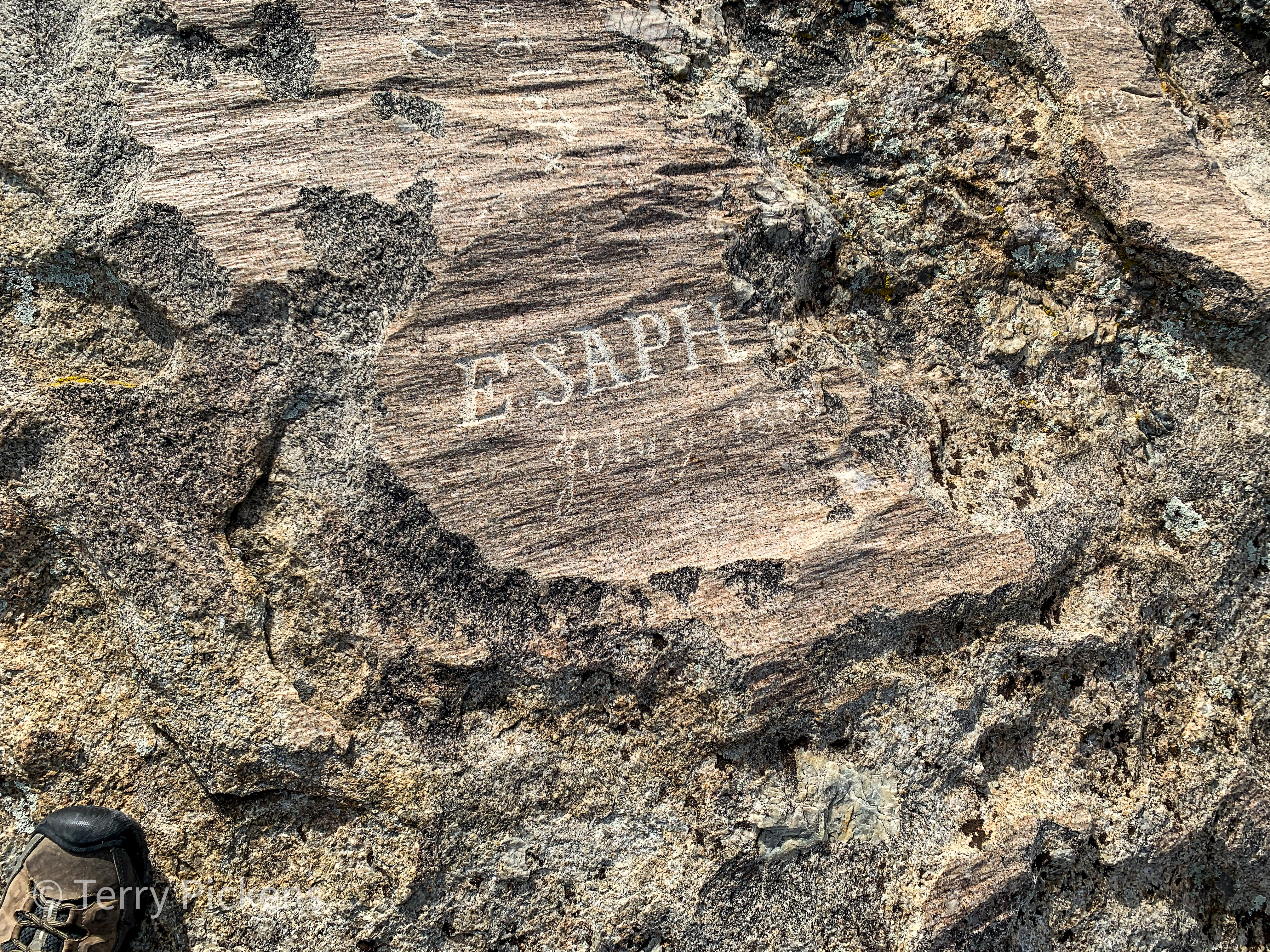
Independence Rock State Historic Site is on the south side of State Route 220 at the Independence Rock Rest Area. Independence Rock is in an area of windblown sand and silt that has grooved and polished the granite to a high gloss. This smoother surface let the pioneers easily carve their names into the rock. It was the approximately 5,000 names carved in stone here that caused Father Peter J. DeSmet to appropriately name this place “The Register of the Desert” in 1840, thus becoming a part of our pioneering history. One of the earliest signatures is a carving dated 1824 by M. K. Hugh. Register Cliff and Names Hill in other locations along the Oregon Trail also contain names left by the pioneers. Independence Rock was a popular camping site for the travelers. 

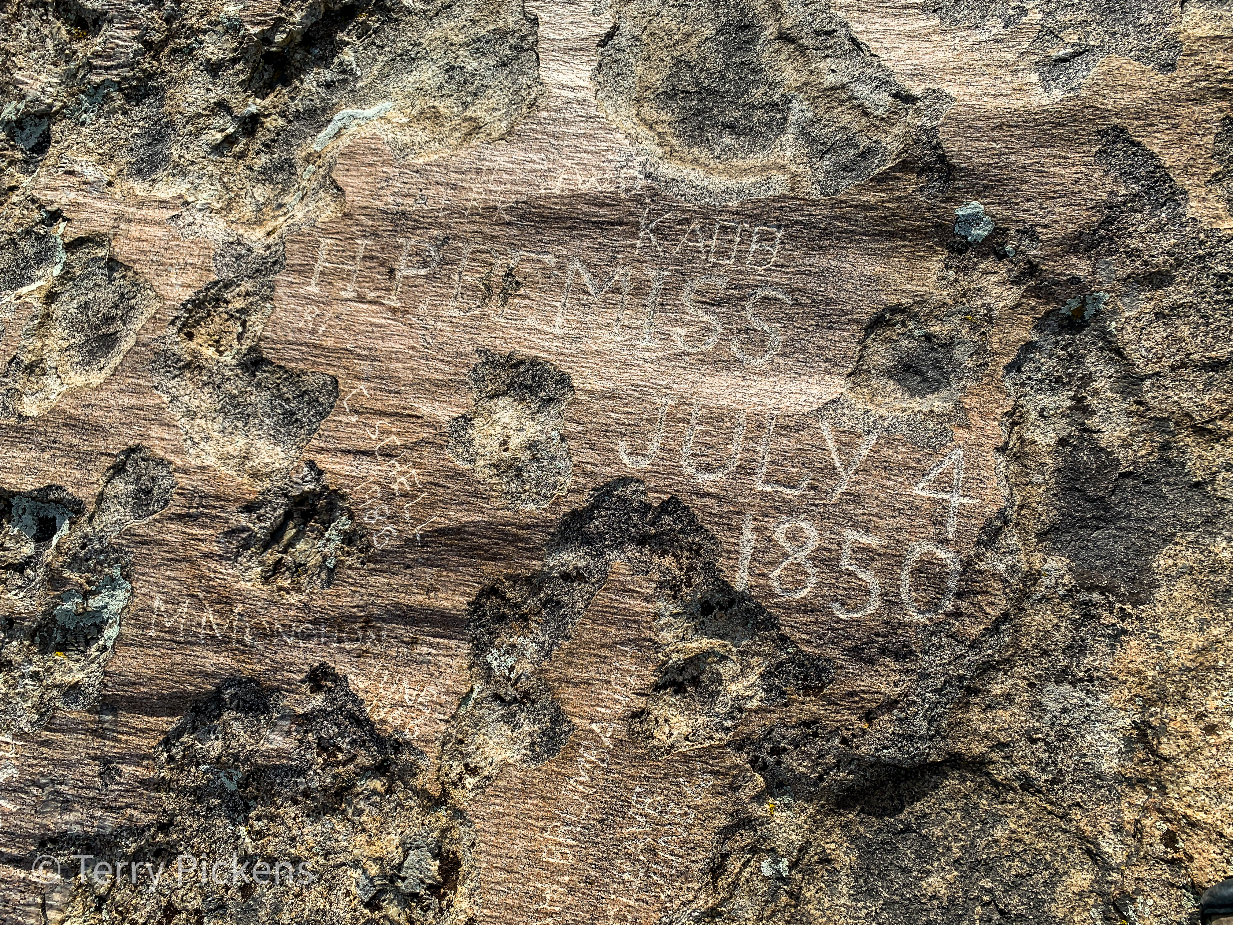
Fur trapper Rufus B. Sage noted that “the surface is covered with names of travelers, traders, trappers and emigrants, engraved upon it in almost every practicable part, for the distance of many feet above its base….”

On August 1, 1843 John C. Fremont, who camped a mile below this site, made this entry in the journal of his 1843-’44 expedition: “Everywhere within six or eight feet of the ground, where the surface is sufficiently smooth, and in some places sixty or eighty feet above, the rock is inscribed with the names of travelers. Many a name famous in the history of this country, and some well-known to science, are to be found among those of traders and travelers.”

Names were placed on the rock through engraving or by painting them with wagon grease, tar or a combination of buffalo grease and glue. Over the years many of these names have flaked off, been damaged, cleansed off by wind or rain or been obscured by lichens. Despite this, thousands of names remain and are a source of delight to those visitors who climb the rock.

On July 4, 1862, Independence Rock, was the site of Wyoming’s first Masonic Lodge meeting and in the 1950’s the Boy Scouts held their annual Jamboree here camped along the base of the rock.

On a little adventure to Wyoming: FOSSIL BUTTE NATIONAL MONUMENT

On my way there I had 2 mornings of glorious sunrises to greet me on my drive from Washington State to Wyoming.

Managed by the National Park Service, Fossil Butte National Monument, was established on October 23 1972 and is located in southwest Wyoming. This monument holds one of the largest deposits of freshwater fish fossils in the world from the Eocene Epoch, 34 to 56 million years ago. In prehistoric times, this part of Wyoming was a sub-tropical lake ecosystem with calm waters, lack of scavengers and a fine sediment that all worked together to create conditions perfect for preserving fossils from the Cenozoic aquatic communities of North America.

For over the two million years Fossil Lake covered an area of 40 to 50 miles (64 to 80 k) long north to south and 20 miles (32 k) wide of southwest Wyoming. Today less than 1.5% of Fossil Lake is protected and managed by the National Park Service. Fossil Butte National Monument promotes the protection of this world-class archeological heritage. The Monument contains only 8,198 acres (33,180,000 m2) of the 595,200 acres (2.409×10⁹ m2) of ancient lakebed. The Green River Formation’s ancient subtropical freshwater lake bed preserved 27 species of fish, 2 bat species,10 mammal species,15 species of reptiles that include turtles, lizards, crocodilians, and snakes, 2 extremely rare amphibian species have been identified, insects including spiders, dragonflies and damselflies, crickets’ stoneflies, true bugs, beetles, wasps, bees, ants, moths, butterflies and flies and plants. As major indicators of climate, plants are allowing scientists to study the ancient ecology of the Fossil Lake area. 

When fossils were discovered, coal miners in the area dug them up and sold them to collectors. Commercial and private fossil collecting is not allowed within the National Monument, although private quarries nearby continue to produce fossil specimens, both for museums and for private collectors.

There are over 80 fossils and casts on display in the Monument’s Visitor Center and a 13-minute video showing how fossils are found and what has been learned along with interactive exhibits. During the summer, lab personnel prepare fossils in public. Summer activities also include ranger programs, hikes, paleontology and geology talks, and participation in fossil quarry collections for the park. 

The base of Fossil Butte is defined by the bright red, purple, yellow and gray beds of the Wasatch Formation. Eroded portions of these horizontal beds slope gradually upward from the valley floor and steepen abruptly. Overlying them and extending to the top of the butte are the much steeper buff-to-white beds of the Green River Formation, which are about 300 feet thick. 

Quarry programs take place Fridays and Saturdays mid-June through late August between 11 a.m. and 3 p.m. If you wish to learn about the research and help search for fossils, meet at the Nature Trail and hike a half mile (0.8 k) to the quarry. All fossils found during the program are collected and contributed to the site’s scientific research.

There are several maintained hiking trails less than 3-miles (4.8k) long and two-track dirt roads (closed to vehicles) that spur off Scenic Drive. Scenic Drive is paved until the Nature Trail then it becomes a dirt/gravel road continuing to the north boundary of the Monument. All hikes allow visitors to take in the site’s unique landscape and geological features. Remember if fossils are discovered do not disturb them and inform a ranger as to the location, so that a qualified team can investigate and determine how to handle the fossil.

Traveling south to the Mendocino Coast – Day 4

Well the rain stopped early in the morning while I was still sleeping although heavy rain is expected to start by mid afternoon today. I revise my plans for today to walk the area right around my Tiny House in the Point Arena – Stornetta Unit of the California Coastal National Monument.

Access for day use only this BLM land is situated along a rugged coastline adjacent to the town of Point Arena, offering spectacular views of coastal bluffs, sea arches, the  Garcia River Estuary and sandy beaches and dunes with 8 miles (12.8 km) of marked paths along the Point Arena Lighthouse Trail. I am going to concentrate on the northern section of the trail that leads to the Point Arena Lighthouse. This path will take me on a 6 mile (9.6 km) walk this morning.

It is a beautiful cold blustery sunny morning walking along the coastal bluffs observing the power of the ocean crash against the cliffs below my feet. This is a pretty level easy walk but the mud and water puddles from the last few days of rain has made some of the stream crossings an interesting jump to keep my feet dry.


At the halfway point of my walk stands an iconic figure in the landscape, the Point Arena Lighthouse. I have seen it grow in the distance as I have walk toward it. Prominently standing on a jut of land overlooking the Pacific Ocean on a barren windswept promontory surrounded on 3-sides with water. Officially established on September 30, 1869 the Point Arena Light Station #496 was first lit on May 1, 1870. As it is getting late in the morning I have a snack before entering the museum in the Caretakers cottage to view the exhibits on the history lighthouse and the rescues made in the surrounding waters. Enjoy the museum and take the walk up into the lighthouse itself to view the horizon from the top you won’t regret it.


As it is close to noon I decide to walk the 2.2 miles (3.5 km) on the paved road back to the room. With sky’s darkening in the distance the dirt path might be a quagmire at the low sections and stream crossings during the return journey if it starts to rain. A pleasant walk without many vehicles on the road I make it back to my Tiny House and proceed to fix a warm late lunch in my kitchen. It was a nice way to warm my body after the chilly walk this morning. Sitting with my book and hot chocolate next to the fire, the rain starts to come down in buckets for the next few hours. What a restful way to spend a vacation, a nice walk in the morning and sitting by a cozy fire warming my chilled bones into the evening.


Days 20 and 21 – Jasper National Park, Icefields Parkway ,Banff National Park and home

Leaving the campsite about 8am it is the final push to Jasper National Park. Stopping behind a long line of cars just minutes from the entry to the park it was discovered that a road closure was in effect from 9am till 11am. Wait it should only be 8:30am, no there was a time change yesterday that proved the undoing of this plan.

IT’S ACTUALLY 9:30

Oh well guess it’s time to climb out of the car and get some stretching done for the morning.

Jasper National Park, Alberta, Canada

Finally right at 11am the line of cars starts to move and entering the park it is time to stop at the visitors center located in the town of Jasper.

Jasper National Park is Canada’s largest National Park with 4,200 sq. miles (11,000 sq. km) that lies just north and adjacent to Banff National Park. This beautiful Park consisting of glaciers, ice fields, hot springs, lakes, waterfalls and mountains was established in 1907 as a forest park and was provided full National Park status in 1930. Part of the Canadian Rocky’s National Park along with neighbor Banff and 2 other Parks it was declared a UNESCO World Heritage Site in 1984.

The resort town of Jasper is the headquarters for Jasper National Park with it’s Visitors Center. This year round resort is with complete facilities for it’s guests, a quaint walkable downtown featuring restaurants, hotels and shopping with nearby Marmot Basin Ski Resort. The town was quite crowded with other visitors this Friday so finding a parking spot proved a little challenging. Finally getting parked it was a medium length walk to the Visitors Center to get aquatinted with the park. Moving around inside was a little claustrophobic so the goal was quickly accomplished and then it is off  into the park.

Icefields Parkway

Rated as one of the top drives in the world, Canadian Highway 93, the Ice Fields Parkway, is a 144-mile  (232km) stretch of road winding its way through 2 National Parks with a beautiful landscape rich in history traversing subalpine forests and the Columbia Icefield.

Going south on the Icefields Parkway we come to Athabasca Falls. Flowing from the glaciers of the Columbia Icefield, the Athabasca River is the largest river system in Jasper and the 75 foot (23 m) Athabasca Falls. Although not very tall, it’s power comes from the flow of the river and the narrow canyon it traverses making for a spectacular view.

In the park is the largest ice field in the Rocky Mountains of North America, the Columbia Icefield. It’s 125 sq. mile (325 sq. km) area is in both Banff National park and the adjoining Jasper National Park.

Just past the Athabasca Glacier on the Columbia Icefields is a small campsite for tents only. Pulling in there 2 spots available, so here is home for the night. 

After getting camp set up it was a short walk along the Parkway to the trail head for a 1.1 mile (1.8 k) moderately strenuous hike to the toe of the Athabasca Glacier. A fabulous walk to the base of the glacier and you can hike right onto it. If you do not feel like walking you can take a bus from the lodge to the glacier where you get onto a Tundra Bus for a drive out onto the glacier.

The next morning it was an early rise and quick breakfast to head south and hopefully get to a few places before the crowds start to gather.

Banff National Park, Alberta Canada

Established in 1885 this is Canada’s oldest national park. Located in the Canadian Rocky Mountains, Banff National Park encompasses 2,564 sq miles (6,641 sq km) of forested, alpine terrain consisting of hot springs, glaciers, ice fields, rivers and waterfalls in a subarctic ecosystem.

Bridal Veil Falls

8-9-16

Weeping Wall showcases the melt-off from the snowfields emerging form fissures in the cliff face emerging as a series of waterfalls.

8-9-26

Getting to Lake Louise it was a quick off ramp to see Moraine Lake. Well it was quite overrun with vehicles and people trying to get to the lake for the morning sunrise. It takes 45 minutes to get to the large parking lot which is overrun with cars. If the parking lot is this full the trail to the lake must be just as crowded. Turning around and getting back to the parkway it was discussed and with the final day of the trip being Sunday at Glacier NP along the popular Going to the Sun Highway it was decided to head out of the Banff early and head home as it was only a 10 hour drive. Glacier National Park is relatively close and can be left for another adventure.

Leaving the Icefields Parkway at Castle Junction it was time to head west along Highway 93 to the town of Radium Hot Springs where the highway turns south for the USA Border Crossing. Stopping in Cranbrook I pick up a quick lunch and then it’s off to the border.

It was a 45 minute wait at the border as it was quite crowded. Finally through It’s south on State 95 to Interstate 90, Highway 395 and finally onto Interstate 84 west to the coast and home.

Arriving home at about 10pm I take a quick shower to hose off the few days of grim due to no showers and fall into bed. Unpacking will be for tomorrow, sleep comes quickly as I am home in my bed after 21 days on the road.

8-10-11


Day 19 – Onward to Jasper and Banff

Getting up in the morning goes a little slow today. It has been a great adventure but many days dong so many things has left me a little tired. After having breakfast and packing up, it’s time to get on the road. Continuing along Highway 16 there is so much to see along this stretch of road from natures wonders to historic sites. I will be back to visit Fort St. James, Vanderhoof, and many of the Provincial Parks along its route.

Crossing back through British Columbia’s 9th largest city, Prince George, the route continues east for Japer and Banff National Parks along BC Route 16, The Yellowhead Highway. Traffic passing through the city is a little strange on my senses, there have been so many empty stretches of roads that all the traffic is hard to come back to. I remember going through Whitehorse, Yukon with the same feeling. So many people it seemed.

8-8-1

Stopping at the Ancient Rainforest Trail to hike on wooden walkways through an ancient forest located in one of the upper Fraser River Valley’s few remaining antique stands of western red cedar is just jaw dropping. These stands include cedar trees that are 800 – 2,000 years old in an area farther from the ocean than any other temperate rainforest in the world, it feels like being on the west coast, such as Vancouver Island. Huge cedars, all kinds of moss, skunk cabbage, wild flowers, and vibrant green ferns flood your senses. Interpretive signs along the trail explain the forests history, wild life, as well as the plant life.

Along the longer trail you can pass a beautiful 30m (98ft) waterfall named Tree Beard Falls, clusters of colossal cedars known as the Sacred Circle, a cedar called Tree Beard that towers mightily with a display of unusual arms, and then to an especially large based cedar that makes up for it’s lack of height in it’s girth. This last is named Big Tree, being 16 feet (5 m) in diameter it is the largest cedar in the Ancient Forest as it stands in silent vigil beside a fallen comrade.

These resilient inspiring ancient cedars are beautiful in their old age, although broken and falling apart in places, they continue to reproduce and contribute to the ecosystem.

It was the weekend and campgrounds were full in the area. Finally finding a place in the group camping area of Mount Robson Lodge. This open area was in a meadow with picnic tables spread around. It was a little far away from the facilities but very quiet even with all the neighbors around.

8-8-2


Day 18 – South on Highway 37 on the way to Jasper and Banff

The mornings adventure starts with a drive back into Alaska to visit the Salmon Glacier, the fifth largest glacier in Canada and the largest road-accessible glacier in the world. An approximate 16 mile (25.75 k) dirt/gravel road leads to a marvelous overlook for the glacier located just back into Canada. This glacier is one of hundreds within the Boundary Ranges. This natural hazard has Summit Lake located at the north end of the glacier and every year in summer the lake breaks an ice-dam and the water flows under the Salmon Glacier into the Salmon River. This flooding causes the river to rise approximately 4–5 ft (1.2–1.5 m) for several days. This river flows beside the town of Hyder, Alaska and empties into the Portland Bay.

Marveling in the immensity of the glacier it is time to head back through Hyder and Stewart continuing 134 miles (215.5 k) south on highways 37A and 37 to the Gitwangak Battle Hill Historic Site. This fortress  utilized a strategic location with several different defensive fortifications: rolling things such as rocks and huge logs covered with spikes down the sides of the slopes of the fortress during raids. The Gitwangak people would drop back to this location during raids on the village. The Battle Hill was never lost during battle. Walking along the trail between the parking lot and the top of the Battle Hill is quite a hike. Stairs lead down into the valley the back up the hill with its commanding views. Right before leaving 2 caretakers of the site pulled up and we discussed the importance of this site to the local First Nations Tribe. All of the people we have met on this journey have been so warm and welcoming.

3 3/4 miles (6k) further down the highway is the Gitwnagak Totem Poles set right in the village. Moved several times due to flooding these are the oldest collection of Totems found in their original village anywhere in British Columbia.  These spectacular poles are a sight to see. Luckily a local was walking and the road and spoke with us for about a half hour explaining the poles and the the people in the village. A very memorable experience I will not soon forget.

Turning east on Highway 16, The Yellowhead Highway, we drove for a little over an hour  and it was lunch time. Entering the Alpine Themed town of Smithers we decided on eating at the Alpenhorn Bistro. Why not eat in a themed town at a themed restaurant. Good food was had and off for the final drive of the day to the Shady Rest RV Park just outside of Houston, BC, Canada.

8-7-11

This RV park had a location for tents adjacent to the RV park. Showers and Laundry facilities are available and the last shower of the trip was a welcome relief. Camping for most of the trip shower and laundry facilities were a little far between which left for many sponge baths along the way. A nice quiet evening and a quick small dinner ending with a quiet nights sleep was well needed


Day 15 – Skagway

Today was a day to visit the town of Skagway. Even though I have been to this town twice before on cruises I have enjoyed its atmosphere. So sleeping in a little bit and eating a leisurely breakfast I drive into the city that is 20 minutes away. Parking just before going over the Skagway River I walk across the bridge and then follow Alaska Street toward the old Gold Rush Cemetery and Lower Reid Falls. It is surprising the number of individuals in the graveyard and is interesting to walk around and read the gravestones.


Continuing toward the town on State Street I arrive in downtown at the waterfront.


Skagway is a small city in southeast Alaska, with a population of 920 residents as of 2010  that is set along the popular cruise route, the Inside Passage. Due to the cruise industry the small little sleepy town of Skagway has become a major tourist destination. Most of the town is included in the Klondike Gold Rush National Historical Park due to its importance as a port of entry for the miners during the Alaskan Gold Rush in 1897 and is home to many gold-rush-era buildings. This was the way north to the Dawson City gold fields via the White Pass Rail Road or, if you couldn’t afford the passenger fee, the Chilkoot Trail.


This town of about 1,000 people boomed to about 10,000 in a little over a year and maxed out at about 30,000 people during the gold rush. After the rush was over Skagway lost population to 3,117 by 1900 and becomes the first incorporated city in Alaska in that year. Invaded by the U.S. army in 1942, tiny Skagway again became a major port on the supply line of materials for the construction of the Alaskan Highway. Taking over the White Pass Rail Road that was built in 1898, the Army hauled supplies and personnel over the White Horse Pass. With 3,000 troops stationed in Skagway it became a rather large town during the war years. The first Marine Ferry arrived in the early 1960’s thus providing another route for people to get to and from Skagway. Although a vehicle road did not get completed until 1978.

I was surprised at the lack of people on the streets on this visit. The 2 times I have been here before there were 3-4 cruise ships passengers disembarking from the boats and it was a little crowded. This visit there was only 1 cruise ship in port and the streets seemed empty. It was so pleasant to experience the city in this state.  I enjoyed walking around town seeing things that I hadn’t had seen in this detail before.


Going into the Visitors center I talked to the ranger and visited the exhibits in a comfortable uncrowded environment.

It was finally lunch time and I decided to eat at Skagway Brewing Company. Having an Alaskan Sandwich of an ale-battered Alaskan Halibut on a toasted bun with lettuce, tomato, red onion and tartar sauce and to wash it down I tried the local Chilkoot Trail IPA. Very filling lunch and also very good. Getting a little tired after the hike the day before I took my time enjoying the ambiance of the upstairs dining room.

It was getting to be mid afternoon and the grocery store will close at 4 so I walked into a newsstand, got a local paper and went to the store to pick up a few food items. Carrying them back for almost 2 miles to the car I drove back to the campsite.

Arriving at camp I walked over to the Chilkoot Trail Outpost to use their showers and get cleaned up before the next stage of the adventure. Walking back to camp I make dinner and sit back to relax and read the newspaper. I ended up walking 7 miles (11.25 k) today and decided to go to bed a little early as it was a travel day to get to the next destination.

Day 12 – Steamboat graveyard and south on the Klondike Highway toward Whitehorse.

It was agreed that we should again reroute due to incoming harsh weather and the ferry strike going on The Marine Highway. The original route was to go across the ferry at Dawson City and follow the Top of the World Highway and the Taylor Highway to Tok, Alaska. Go south along the Alaska Highway along the Haines Highway to Haines, Alaska and take the ferry to Skagway. With the ferry strike it was decided to go south to Whitehorse, Yukon, Canada and directly to Skagway, Alaska via the South Klondike Highway.

Waking up early we drove into town and ate breakfast at Belinda’s Restaurant for some good ole pancakes and eggs.

After breakfast we parked along Front Street and walked to the ferry crossing of the Yukon River and crossed to walk to the Sternwheeler Graveyard located past the campground on the west side of the river. Tucked into the trees you will find the wooden remains of seven paddlewheelers. Once the primary mode of transportation in the region, these were abandoned when other transportation options became more popular.


Scuttled off the side of the river this graveyard hulking remains of wooden paddlewheel ships are broken and damage hulks that looks as though they were crashed onto shore. Most of the wrecks have collapsed but a few of the ships are still intact enough to explore, and many of the paddlewheels remain thanks to their metal skeletons.

After this interesting exploration of the ships it was time to walk back and head south toward Whitehorse. An interesting trip we are now doing in reverse from a few days ago on the way to The Dempster Highway.


Arriving back in Carmaks it was time to stop for gas and pickup a few things at the adjacent store. After shopping it was time for a quick lunch in the parking lot before continuing on to the destination for the night, Lake Leberge.


Lake Laberge is a widening of the Yukon River north of Whitrehorse. At 31 miles (50 k) long and from 1.25 to 3 miles (2 to 5 k) wide its water is always very cold, and its weather often harsh and variable. Its English name comes from 1870 commemorating the first French-Canadian to explore the Yukon in 1866, Michel LaBerge. During the late 19th and early 20th centuries winter sternwheelers carrying goods early in the shipping season on Lake Laberge regarded the lake as trouble, as it was one of the last areas of the river to thaw of ice.


Entering the campground it was signed as full but we continued around to see if there might be an empty campsite and to see the lake. Luckily a husband and wife were packing up to leave and asked if we wanted the campsite. We said thank you yes and waited 20 minutes as they packed up. What a wonderful camping spot, very close to the lake with a beautiful view from the site. Now for a nice dinner and to sit by the lakeshore and enjoy the scenery with peace and quiet.


Sa far this trip has just been outstanding and I suspected it would continue on this way.


Day 11 – Dawson City

Close to 100,000 prospectors set off over the Chilkoot Trail in Dyea/Skagway, Alaska on foot then sailed up the Yukon River to find their wealth in the gold fields surrounding Dawson City, Yukon. With a population of only about 1,900 residents this National Historic Site and UNESCO nominated town has many restored buildings and sites to explore. A few of the places to explore and enjoy a trip back in time are a walking Tour of town, the Palace Grand Theater, the Jack London Museum, Diamond Tooth Gertie’s to join the Sourtoe Cocktail Club by having a shot with an actual toe in it at the Sourdough Saloon in the Downtown Hotel (the toe must touch your lips), see the SS Keno the last steamer to run the Yukon River, discover the areas history at the Dawson City Museum and just outside of town explore the grand old Dredge #4, Discovery Claim National Historic Site and the steamship graveyard.

7-31-17

First up for a bit of vehicle maintenance, the vehicles needed a complete cleaning with all the mud buildup from the drive yesterday. It took about 30 minutes each to get most of the dirt removed from the outside.

After the cleanup it was over to Dredge #4 to investigate. A guided tour is available to explore the inside of the dredge. An interesting informative tour is provided but it is not inexpensive, although I felt well worth the cost.

7-31-1

Dredge No. 4 mined gold from 1913 to 1959. This wooden-hulled bucketline sluce dredge  is now located along Bonanza Creek Road about 8 miles (13 k) south of Dawson City along Upper Bonanza Creek road. This the largest wooden-hulled dredge in North America was designated a National Historic Site on 22 September 1997.

Designed by the Marion Steam Shovel Company it was hauled in pieces to Dawson City at a cost of $134,800 for shipping which was then built by the Canadian Klondike Mining Company on site at Claim 112 near Ogilvie Bridge, the current location of the bridge over the river along the Klondike Highway to Dawson City. It moved to its current location along Bonanza Creek by digging a path and filling in the area behind itself in its own pond.

Excavating gravel at 22 buckets per minute with 72 large buckets that processed 18,000 cubic yards (14,000 m3) of material per day. In use from late April or early May until late November each year, and sometimes throughout winter, it captured nine tons of gold during its operation.

Continuing along the dirt road we made a stop at the Discovery Claim National Historic Site where gold was first discovered in the area for a short walk around the displays explaining the mining operations of the area.

Stopping by a small tourist stop with a souvenir shop, old buildings and quite a lot of old mining equipment I explored the old buildings and equipment having a fun time with my camera.

Back in town I dropped the car off at the hotel and wandered the rest of the afternoon and evening around the streets, shops and museums of Dawson City. First up was the Dawson City Visitors Center to look around the exhibits and get an idea for a much needed very late lunch. Leaving there with several ideas I strolled across the street to the NWT Dempster Highway Visitor Center to see what was missed during the previous few days. This would be a good stop if you are going up the Highway after your visit here in Dawson City.

After talking to the very nice informative person working there I continue my wandering to the Triple J Hotel and restaurant for my late lunch. I had the tasty Wild Salmon Burger with a caper aioli and an iced tea. Sitting on the outside porch I enjoyed my meal watching the activity happening on the street it was a very good relaxing meal.

7-31-44

I sat on the porch on the left for lunch. What a wonderful place to have lunch.

After lunch I continue on to the Dawson City Museum where I explore the exhibits on 2 floors of the old Territorial Administration Building discovering the natural history of the Klondike Gold Fields through exhibits, displays, dioramas and informative shows. You explore the history of Yukon’s First Peoples and early explorers. Experience the Gold Rush through the stampeders and entrepreneurs, and the visionaries. I was fortunate enough to see a live demonstration of a sluce shaker box in action and how gold was recovered from the river and stream beds.

7-31-45

Walking to the outskirts of town I visit the Robert Service Cabin. Service was a British born poet referred to as the “the Bard of the Yukon”. He was one of the most successful poets of the Twentieth Century. who arrived in the Yukon as a bank clerk turning vivid tales, told to him by veterans of the great gold rush, into classic poems. Robert Service arrived in Dawson City in 1908 continuing  to write about his northern adventures until his departure from Dawson, and the Yukon, in 1912. Sadly the cabin was closed for the day so I couldn’t get a glimpse inside to see how this gentleman lived.

7-31-19

Just down the street was Jack London Museum and Cabin. This museum and cabin shows the time Jack London spent a year in the Klondike. Trying his hand at mining he still spent most of his time writing stories that would make him a well known author. It again was closed due to the late time I had passed there.

Just west is a pedestrian-bicycle trail along the Klondike and Yukon rivers that I followed back to my tent cabin  for the evening. Stopping at the store for a few items I continue to the cabin to shower, due some laundry and relax for the evening. Another travel day in the morning so must rest up.

It was amazing that just before the grocery store I noticed a large European based adventure RV turning into a parking lot. I had to get a closer look and hopefully talk to its drivers. I met a wonderful couple, he from Luxembourg, a small European country surrounded by Belgium, France and Germany and his wife from France. I talked with them for about an hour listening to their adventure so far and where they are going on their long trip.

As a side note, they stopped by my house when I returned from the adventure for dinner and the stayed the night on their trek to Mexico and Central America. I wish them well on their journey.

Days 10 – Returning to Dawson City

Returning south along the Dempster it is decided to continue all the way from Inuvik to Dawson City in one day. The weather has turned bad this day and under a constant sometimes heavy rain it was decided to push on.

Reaching Eagle Plains for the required fuel stop we head over to the small restaurant to pick up a quick bite to eat. A group of travelers from Australia are enjoying their meal and we talk to the for about a half hour before leaving them as they head north.

The closer we got to the Klondike Hwy the weather was changing for the better. We continued on as it was not that far to Dawson City at that point.

Upon reaching the Klondike Hwy, Canada 2, it is time to head west for Dawson City, Yukon Territories.

7-30-7

It was 7:30 by the time we arrived in Dawson City and being very hungry, stopped at Sourdough Joe’s for a bite to eat. I had a burger with bacon, cheese, chili, an egg and a small salad. DELICIOUS.

7-30-9

Sourdough Joes Burger

We start the search for a place to spend 2 nights here and decide to splurge on a room. All the places we checked were fully booked but luckily one manager called around to other locations for available rooms. It was discovered an establishment named The White House had 2 tent cabins available for the 2 nights we planned on staying. Driving the short 1/2 mile there we look at the rooms and decide this is the perfect place to wind down after the adventure north we just had. Renting the 2 tent cabins with mine having a queen bed, a single bed, lounge sofa, small dining table and kitchen utensils for heating water for tea/coffee.. This was no ordinary canvas tent accommodation, it was provided with a wooden floor and door, covered porch and a hard translucent roof covering, shared bathroom and shower and a small outdoor kitchen/dining area to prepare food, this was a perfect place to enjoy 2 nights of glamping comfort.