Day 13 – Whitehorse, Yukon, Canada and onward to Skagway, Alaska

Whitehorse was only about an hour away from the campsite so a relaxing morning sleeping in an extra half hour and a leisurely breakfast awaited.

After packing up we talked to a wonderful couple from Whitehorse who come here to camp, boat and fish on their days off. After talking for probably an hour and a half and getting recommendations for Whitehorse and the afternoon trip  it was on to Whitehorse.

Whitehorse, Yukon has been the capitol city of the Yukon since 1953 and is the northern terminus of the White Pass & Yukon RR from Skagway, Alaska which ferried prospectors to the riverboats plying the Yukon River to the northern goldfields surrounding Dawson in 1900.

Whitehorse’s second boom time was during the construction of the AL-Can Highway in 1942 when many workers converged on this small town. Construction worker population grew form 2,500 to 3,800 with 1,800 tons of materials and equipment being shipped by rail from Skagway each week in 1943.

This, the only city of the Yukon Territories, has a population was 33,897 people per the 20111 census. A pleasant place to visit as it provides all the services of any town or city. Many attractions and good food establishments are here for the visitor to enjoy.

Parking at the Visitor Center downtown it was off to a recommended spot for lunch, Klondike Rib and Salmon BBQ. Such a fun atmosphere to enjoy as was the wonderful meal. I will definitely go back there for another meal to try out a different menu item, mine was fantastic and very filling.

8-2-1

Heading back to the Visitor Center to gather some information on the area it was time to visit a real Sternwheeler, the S.S. Klondike that sailed the Yukon River between Whitehorse and Dawson City.

8-2-2

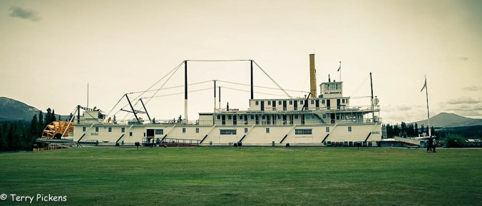
The S.S. Klondike National Historic Site is an old stern-wheeler that once plied the Yukon River carrying passengers, mail and supplies to Dawson City. With only a four and half month shipping season the boats were hauled out of the water on skids in the Whitehorse Ship Yards for the winter months of a frozen Yukon River. This interesting attraction lets you board the ship and on a self guided tour to explore the many areas of its interior at your pace.

Built in 1929 this boat was the largest on the Yukon. Sternwheelers were less vulnerable to paddle damage than the side-wheelers. Built in 1929 an accident sunk her in 1936. Refitted that winter the Klondike went from an ore hauler to carrying passengers and cargo. She carried 300 tons (270 tonnes) of cargo with a draft of only 40 inches (1 meter) and 32 – 1st class passengers.

The lower deck just above water line was for the crews quarters, the cargo, engine room, boilers and with bunks lashed to the sanctions at the aft sleeping accommodations for 2nd class passengers. The next deck held the 1st class cabins, Dining Room for the passengers and a separate one for the crew, Kitchen, Observation Lounge at the front of the ship and the Sun Deck at the stern. Above that was the Boat Deck housing the Officers Cabins. Finally at the very top was the Wheelhouse or “Monkey Island”. Situated well forward and high it gave an unobstructed view for the Master and Pilot to navigate the ship though the dangerous waters.

Next up it was a drive to the outskirts of town to visit Miles Canyon. The canyon is a cross section of volcanic rocks where the Yukon River cuts through a succession of flows south of  Whitehorse. The White Horse Rapids in Miles Canyon provided a significant challenge to the prospectors heading to theDawson City and the gold rush providing the upstream terminus of the Paddle wheelers. The rapids are now tamed by dams along the river.

Finally it was off the Yukon Beringia Interpretive Center that explains the Yukon’s history during the Ice Age. Being largely ice-free during this timea local cave provided the oldest evidence of human habitation in North America has been found.

Getting a late start the following attractions were missed but sound fun and interesting making for another visit an enjoyable adventure.

The MacBride Museum houses artifacts and stories of the events and people who settled and built the Yukon.

Waterfront Walkway provides a walking path along the Yukon River connecting several parks along its path.

Yukon transportation Museum is home to the world’s largest weathervane, an old DC-3 and provides exhibits on the transportation used in the far north.

Old Log Church Museum is one of the oldest buildings in the city completed in 1900 and hides stories of the older pioneers of the region.

Yukon’s oldest brewery north of the 60th parallel, the Yukon Brewing Company.

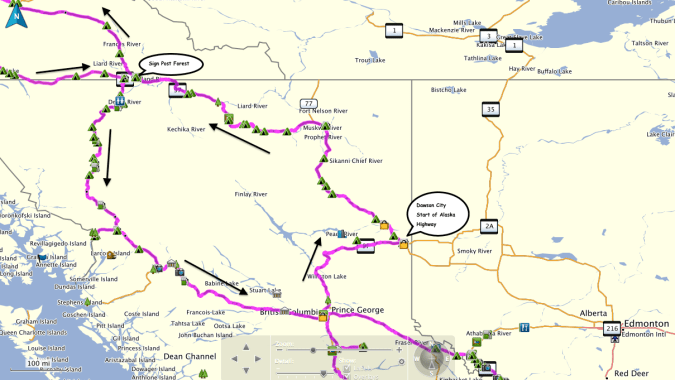
Leaving Whitehorse late in the afternoon the route turned south on the South Klondike Highway to its terminus in Skagway, Alaska. This relatively short 2.5 hour drive of 105 miles (169 k) was a breathtaking day of travel. This 2-lane road of spectacular scenery had many turnouts for viewing vast landscapes and intimate waterfalls. Before the highest point of the road at 3,292 feet (1,003 m) at Whitehorse Pass there is an 11. 5 mile (18.5 k) 11 percent grade of roadway.

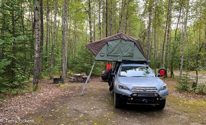
Turning west right before entering Skagway along the Dyea Road, Dyea Campsite was the location for the next 3 nights of the journey for 2 full days to explore Skagway, Old Town Dyea and the Chilkoot Trail.

8-2-18

The Northern Adventure – Journey to the Yukon

Having already started the first post of this adventure HERE although I should explain what this Journey is about and where in shall go. 

But First:

ADVENTURE – An exciting, daring, bold, risky or very unusual experience or undertaking fraught with physical, financial or psychological risks.

Lets go on an Adventure

What does this mean? It can be different for everyone; skydiving, mountain climbing, scuba diving, river rafting, caving (spelunking) traveling, exploring…… anything that is outside the ordinary for that individual is an adventure. Many make their adventures a way of life and never stop. For some it is just a day, weekend or short trip. Does it need to involve speed, height, a high level of physical exertion or highly specialized gear, some would say yes. I do not think that at all, it is up to the individual the extent of the adventure to be accomplished.

The Individuals:

The explores will consist of 2 individuals who are basically strangers, we came together on social media in our interests for the outside and vehicle exploration. Communicating through the computer is all we done as we live in different states. The team consists of Heather’s 2015 Subaru Outback (#heidi_roo), and myself in a 2017 Subaru Outback (#sled_rider).


The Journey:

It will involve a drive from Vancouver, WA to Dawson City, Yukon Territories, Canada, up the Dawson highway to the Arctic Ocean at Tuktoyaktuk, YT, Canada and back. It is something I have never done and it has always been on my bucket list. I have taken 2 cruises to Alaska and have loved the experiences. I now want to experience the lands of Canada and Alaska from the ground driving through the countryside.

Map 1Map 2Map 3Map 4

  • Will it be an adventure? …..yes as this will go far north as you can drive in Canada.
  • Will it be exhilarating? …..Yes.
  • Will it be fun and exciting? …..Definitely.
  • Is this outside the box for travels…..Definitely.
  • Am I excited to plan and start this adventure? …..OH YES.
  • Has this route been carved in stone…..NO, it will change even as we travel I’m sure.

The trip will leave Vancouver, WA and head up Interstate 5 to the Canadian Border. Crossing into British Columbia, Canada the journey continues north to Prince George, BC and to the start of the Alaskan Highway in Dawson Creek, B.C., Canada. British Columbia has a population of approximately 4,751, 600 in 364,764 sq. miles (944,735 sq. km) making it the 3rd largest province in Canada.

Heading north from Dawson Creek we will go along The Alaskan Highway, Canada Highway 97, passing through Fort Nelson and entering the Yukon Territories, Canada just before Watson Lake to visit the Sign Forest. The Yukon has the smallest population of any Province/Territory of Canada at approximately 37,858 with a land area of 186,661 sq. miles (483,450 sq. km).

What is the difference between a Province and Territory? Territories are administrated differently than Provinces. Provincial government powers are laid out in the Constitution, whereas the territories are given powers from the federal government, thus the territories control less of their own affairs.

Heading north on The Campbell Highway, Canada 4 we will stop in the old mining town of Mayo / Keno then will then make our way up the Dempster Highway, Canada 5, crossing the Arctic Circle, Inuvik, Northwest Territories, Canada and then continue the final 130 km on the new all season road to Tuktoyaktuk, Northwest Territories, Canada and the Arctic Ocean. The Northwest Territories has an approximate population of 44,469 that live in an area of 452,480 sq. miles (1,171,918 sq. km), this province has about the one sixth of the land area of Canada making it the second largest and most populous territory of Canada.

I mention the population and sizes of these Territories as they are still sparsely populated; a majority of Canadians live very close to the border with the United States. The population for the state of California is estimated to be 39,497,000 in 2017 with an area of 163,696 sq. miles (423,970 sq. km). The state of Washington has approximately a population of 7,535,591 and a land area of 71,362 sq. mi (184,827 sq. km). When you look at these numbers California has 241 people per sq. mile (93 people per sq. km), Washington has 106 people per sq. mile (40 people per sq. km), while The Yukon with 6.5 people per sq. mile (1 per sq. km) and The Northwest Territories having 1 person per sq. mile (about 1 person per 2 sq. km). So as you can see the farther north we head the less people, cities and urbanization will be encounter.

SOUNDS LIKE A GOOD PLAN.

After dipping our feet into the Arctic Ocean and exploring the area it will be time to return to Dawson City, Yukon Territories, Canada to explore the old mining district and town. The journey will then cross the Yukon River on a ferry as we head west to Chicken, Alaska along Top of the World Highway. Continuing on the Taylor Highway to the junction with the Alaskan Highway, we turn south for Haines, AK along the beautiful Haines Highway.

Backtracking to the Alaska Highway the route passes through the Capitol of the Yukon Territories, Whitehorse, the only city in the Yukon Territory. Leaving Whitehorse we will head toward the Cassiar Highway, Canada 37, and back to Prince George. From Prince George it is east to Jasper, Alberta, Canada to visit Jasper National Park and Banff National Park along the Icefields Parkway to Banff, Alberta, Canada.

From Banff we will enter back in to the continental United States and journey along the Going-to-the Sun Highway in Glacier National Park. After a short stay in Glacier NP it is time for all to return to our home bases.

·      Adventure? …..I think so.

·      Something out of my ordinary routine? …..DEFINITELY for me.

So what does this involve? A lot of investigation on the Internet, reviewing maps and with the help from individuals who kindly share their knowledge of the areas that are being visited. I will be camping along the way when possible and staying at motels, hotels or lodges only as needed to freshen up.

·      Will schedules change?

·      Will additional sites present themselves?

·      Will destinations be revised?

All a YES to me, it is still being planned so anything is all possible.

Since we will be camping most of the nights along the journey. Some of the camping equipment in my vehicle will include Roof Top Tent, sleeping bag, stove, pots, fry pan, plates, cooking and eating utensils, camp chair and table, mosquito repellant and head netting, camp lights and batteries, propane, lighter and matches, trash bags, cleaning bucket, 5 gallon drinking water container, a refrigerated cooler and food storage containers, a hand held GPS, first aid kit, whistle, cordage (para-cord), knife, bear spray, maps, compass and Garmin In-Reach Satellite Emergency System . Communication between vehicles will be with HAM, GSMR and Citizen Band (CB) radios. We will have at least one complete set of tools and vehicle recovery gear for any unforeseen issues with mine having a winch permanently installed.

This should be a great Journey.

Canada PLANNING PART 2 – Onward to Jasper and Dawson, Yukon, Canada

Lets go on an Adventure

ADVENTURE – An exciting, daring, bold, risky or very unusual experience or undertaking fraught with physical, financial or psychological risks.

Any ideas of what to visit in the areas I am traveling would be appreciated, not all sites are noted somewhere, secret spots abound. And if you share these secret spots with me to enjoy I will not post where they are but will relish in the beauty around me and be grateful you trust me with this shared this information.

Continue reading