I heard of this climb in a magazine promoting hiking trails surrounding Vancouver, WA. I decided to climb the up the short 1.8 mile (2.9 k) round trip to the top of this rock when the weather got better. At only 700 foot (213 m) elevation gain this may seem like an easy hike, but don’t fool yourself it’s a 700 foot (213 m) climb in only 0.9 mile (1.45 k) involving many switchbacks, steep grades, and stairs the entire distance. Who needs a gym with a stair master when you can go out here.
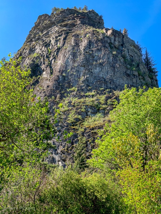
A prominent and distinctive geological feature along the Columbia River Gorge, this 848-foot (258.5 m) high landmark was the core of a volcano 57,000 years ago. The rock that remains is the lava core that was not washed away by the massive force of ice-age flooding. During the last Ice Age an ice dam formed in Idaho creating an enormous lake behind a 1/2 mile (804.5 m) thick block of ice.
This ice dam failed numerous times sending an enormous amount of water down through the Columbia River Gorge flowing at 60 mph (96.5 k/hr) up to 600 feet (182.9 m) deep. The city of Portland, OR could have been 400 feet (121.9 m) under water during these floods. This amount of water caused erosion created the hanging valleys and waterfalls that are prevalent along the river right now.
The trail built by Henry Biddle between 1915 and 1918 is one of the oldest trails in the area. At the time Biddle built the trail with handrails and bridges to the top for people to visit. His family later donated the land to the Washington State Parks in 1935.
An important landmark along the Columbia River this rock served as a landmark to local tribes denoting the last of the rapids of the great river. Originally named “Beaten Rock” by Lewis & Clark in their journals on the Voyage of Discovery in 1805, it was renamed on the return journey “Beacon Rock” for unknown reasons.
“The entire trail is a near-continuous series of switchbacks, many of them less than 20 feet long and the trail loops over itself at least twice. I counted 52 switchbacks, while one of my sons counted 54 and the other came up with 49. That says less bad about our educational system than it does good about the distracting views. The trail is completely lined by handrails and is safe for all but the tiniest walkers.
Most of the trail is up the open, west side of the rock, providing views down the river of Angel’s Rest and Cape Horn. With little shade or water, this part of the trail can be really hot in the summertime. Beacon Rock actually has two summits and the trail works around the south one and proceeds up the east side toward the higher, north summit. The trail is forested here, but the terrain is still rocky enough to provide great views of Hamilton Mountain and the river toward Bonneville Dam. At the summit, a few quite large stairs lead to the summit pinnacle. Here, trees block a bit of the view, but it’s certainly worth seeing.
The wind is usually howling on one side of the rock and dead calm on the other side, creating a dramatic difference in the perceived temperature. You’ll need a jacket most days, but you’ll carry it a lot.” – OregonHikers.org

such wonderful terrain…looks like spring winds like here…sending you joy and all good things…have more fun Terry ☺️🤗
LikeLiked by 1 person
Thanks for sharing
LikeLiked by 1 person
Great views!
LikeLiked by 1 person
Very informative! It’s a beautiful location too.
LikeLiked by 1 person