Traveling south to the Mendocino Coast – Days 6, 7 and 8

The final day of my stay at the tiny house was spent with a walk along the coast south. After a quick breakfast I headed out for the 3.9 mile walk I would take today on this sunny but very blustery day. The wind was blowing from the ocean sending the spray of the waves up the bluff face onto the highlands where I was walking.

This rough coastline causes my mind to wander back to the days of the small wooden sailing ships plying the coast. The sailors relying on only the rough crude maps, compasses and shear luck fighting fog, harsh weather, winds, and the powerful ocean currents exploring the coasts for suitable anchorages and calm protected harbors.

Through the day my walk consisted of a changing weather from sunny, windy and cold to overcast, windy and colder temperatures. Late into my walk the overcast gave way to intermittent showers as I walked back to my tiny house.

Packing up my belongings I was to leave in the morning for a 2 day excursion along the coasts of California and Oregon. I was sad to leave this wonderful room and area. I will be back for additional stays here to explore more of the area, north and south of Point Arena.

Leaving early in the morning I experienced rain on and off all morning until I left the Coast Road to head inland to Highway 101. A pleasant drive for the rest of the afternoon I arrived at my first stop for the night in Coos Bay, Oregon and enjoyed a cozy night in an Air B&B named the Itty Bitty Inn.

This wonderful old Roadside Inn was built in 1950 and consisted of only 5 rooms, each with it’s own signature decoration. I loved the room I was in, a very comfy old style design named the Folk Americana Room. Other rooms are themed as The Star Trek – Enterprise Room, The Tiki Cha Cha Room, The Tiki Lounge Room and finally That ’70’s Room. This is a very kitzy place and a place I will stay again if it is available. Friendly people run this outstanding Roadside Inn and are trying to preserve this American treasure, I so support that.

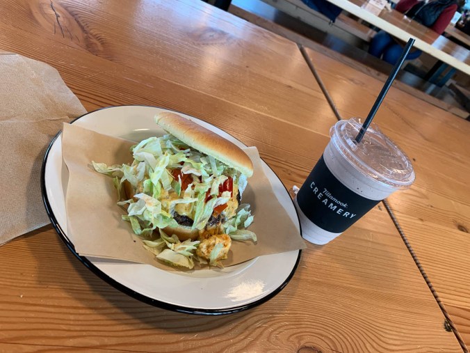
The next day I awoke and left to continue north and my lunch stop at Tillamook Creamery. Visit the Viewing Deck, take the tour, explore the farm exhibit, eat at the Dining Hall and shop for food and gifts in the gift store. This is a Co-Op that has been providing dairy products for 110 years that is owned by the farmers. I enjoy their cheeses and ice cream so for lunch I had the Tillamook Cheeseburger. Consisting of a 6 oz beef patty, house made pimento cheese (Tillamook Monterey Jack, Smoked Cheddar, Pepper Jack, and Cream Cheese), shaved iceberg lettuce, Mama Lil’s Peppers, and special burger sauce on a brioche bun along with a chocolate milk shake.

20-1-17-1

Oh my, I was very filled and happy for the rest of my drive north to Astoria, Oregon and along the Columbia River back home later that afternoon.

Traveling south to the Mendocino Coast – Day 4

Well the rain stopped early in the morning while I was still sleeping although heavy rain is expected to start by mid afternoon today. I revise my plans for today to walk the area right around my Tiny House in the Point Arena – Stornetta Unit of the California Coastal National Monument.

Access for day use only this BLM land is situated along a rugged coastline adjacent to the town of Point Arena, offering spectacular views of coastal bluffs, sea arches, the  Garcia River Estuary and sandy beaches and dunes with 8 miles (12.8 km) of marked paths along the Point Arena Lighthouse Trail. I am going to concentrate on the northern section of the trail that leads to the Point Arena Lighthouse. This path will take me on a 6 mile (9.6 km) walk this morning.

It is a beautiful cold blustery sunny morning walking along the coastal bluffs observing the power of the ocean crash against the cliffs below my feet. This is a pretty level easy walk but the mud and water puddles from the last few days of rain has made some of the stream crossings an interesting jump to keep my feet dry.


At the halfway point of my walk stands an iconic figure in the landscape, the Point Arena Lighthouse. I have seen it grow in the distance as I have walk toward it. Prominently standing on a jut of land overlooking the Pacific Ocean on a barren windswept promontory surrounded on 3-sides with water. Officially established on September 30, 1869 the Point Arena Light Station #496 was first lit on May 1, 1870. As it is getting late in the morning I have a snack before entering the museum in the Caretakers cottage to view the exhibits on the history lighthouse and the rescues made in the surrounding waters. Enjoy the museum and take the walk up into the lighthouse itself to view the horizon from the top you won’t regret it.


As it is close to noon I decide to walk the 2.2 miles (3.5 km) on the paved road back to the room. With sky’s darkening in the distance the dirt path might be a quagmire at the low sections and stream crossings during the return journey if it starts to rain. A pleasant walk without many vehicles on the road I make it back to my Tiny House and proceed to fix a warm late lunch in my kitchen. It was a nice way to warm my body after the chilly walk this morning. Sitting with my book and hot chocolate next to the fire, the rain starts to come down in buckets for the next few hours. What a restful way to spend a vacation, a nice walk in the morning and sitting by a cozy fire warming my chilled bones into the evening.


Traveling south to the Mendocino Coast – Day 3

After a restful night listening to the rain all night it starts to calm down as I make my breakfast before heading back north again to the little town of Mendocino, CA. This quaint Victorian town is a very picturesque community on a cliff overlooking the Pacific Ocean. A high end town it is full of places to stay, eat and shop.

I park on Main Street in front a park to walk the Point Mendocino Trail along the highlands over looking Mendocino Bay and the ocean. A lovely walk on this blustery wet day but well worth the effort. You will overlook a sink hole cave made from erosion from the wave action and Point Mendocino Cave. Again the tide was high and waves were erratic so I stayed on the highlands away from the powerful surf hitting the area that day.


I arrive at the north end of this part of the trail and make my way back into town.

20-1-12-4

My first stop is Mendocino Jams and Preserves to investigate the items for sale. I find a nice spicy Mango Habenero Jelly I will take home to my sons family and a very good tasting homemade “Robert’s Mendocino Catsup”, made by the owner, I will enjoy myself. I pass many artist shops, tourist trinket shops and restaurants on my way to my lunch destination, Frankie’s. This family-run pizzeria serves specialty pies, salads & organic falafel, plus ice cream & beer. I had the baked Falafel and it was very filling. Although I must say the pizzas I noticed being served to other patrons look delicious also.

Leaving Franki’s I noticed another Mendocino Chocolate Company shop.  I wanted to take a “Pacific Fire” home for my son and have several of the “Surf’s Up Peanut Butter” and “Pacific Fire”chocolates to have for myself during the week. Yes I am a Chocoholic, I love my chocolates.

It was getting late in the day so I returned to my car to proceed back to my place when I stopped to talk with a gentleman that was living out of his Volkswagen Westfalia Vanogon with his wife and 2 dogs. I spent about 45 minutes enjoying my conversation with him as the rain started up again. Saying my good bye I drove the 40 minutes back to the Tiny House for a light dinner and again resting and reading in front of the fire as the rain continued on the rest of the night.

Traveling south to the Mendocino Coast – Day 1

It’s been awhile since my past post although many things happened during the first part of the year with numerous day trips that I really didn’t take photos of, just deciding to enjoy the moment. Now it’s off for more adventures.

First trip this year was a trip south to the Mendocino Coast of Northern California for a week of relaxing, well sort of.

After a quick jaunt down Interstate 5 and then west along Highway 199 I arrived at the coast at Crescent City, CA. Turning south along Highway 101 I reached my first stop for the night in Eureka,CA staying the night at an Air BnB where I had previously stayed, the Colorful Corner. A small quaint private room with a wonderful host who met me at the door and we proceeded to gab away like old friends for about an hour. I had visited this town before and it has some wonderful Victorian Architecture scattered through it.


I asked her about a place to eat that I noticed was close to her house and she said it was a great place to eat. Good food and atmosphere. It was a very small place that you should have reservations for but it was still early and I sat at the bar to eat so I got right in.

The Brick and Fire Bistro has an outstanding rustic and cozy vibe. Sitting at the bar I saw directly into the kitchen and was right in front of the wood fire oven. I had a wonderful meal talking to the friendly staff and seeing how the food was prepared was a great benefit for a seat at the bar. I decided on the chicken, brie & asparagus pizza that is served on a classic Italian white crust with pine-nut sage brown butter pesto, roasted chicken, shaved asparagus, red onion, brie & parmesan cheeses which was baked perfectly in the wood fired oven. DELICIOUS.


After filling my belly it’s back to the room to sleep. As I was leaving in the morning my host opened her front door and we again talked for about an hour before leaving to continue my southbound journey. What a delightful host and the room is beautiful, well stocked and very clean. I will be back many times here if the room is available when I pass through.

A short dive took me to the town of Ferndale, CA. The town is off the main Highway by a few miles but worth the detour. This small Victorian town is vintage America with an historic Main Street to browse and enjoy a meal. First settled in 1852 it is at the northern gateway to the Humboldt Redwood National and State Parks.


Once in the Parks I got off of Highway 101 and proceeded on a parallel road named Avenue of the Giants. This scenic highway is the former alignment of U.S. Route 101 that continues to be maintained as a state highway (State Route 254). A drive among the redwoods that is lined by gigantic trees along it’s 31-mile length providing a much slower more scenic route through the redwoods with many stops for hiking and day use activities. Stopping at the Drury-Chaney grove I took the two and half mile loop from the parking lot wandering along it’s path under the majestic canopy of these large Coastal Redwoods.


Back on Highway 101 after that invigorating walk, I continue my route turning on Highway 1 (Shoreline Highway) to my room for the night at Lighthouse Point Resort near Point Arena, CA. The resort is made up of small cottages (tiny houses actually) in a wonderful setting set back from the ocean by about a mile in a grove of trees. There are no entertainment facilities of any kind nearby and limited cell service and no or very expensive WiFi, although there is cable TV provided. But that’s what I so enjoyed about this location, secluded and very quiet where you could unplug from the modern world in a comfortable setting.


Alabama Hills, Lone Pine, CA

I had just an evening and a few hours the next morning to explore the Alabama Hills. I got in after dark and it was very windy and cold Halloween night so I didn’t want to spend too much time outside. I shall return with more time to explore the Movie Road and Movie Flats to find the locations of the arches and television / movie shooting locations. The Museum of Western Film History in Lone Pine will provide a history and has information and self-guided tours of the area.

Alabama-Hills-Movie-Location-Map

Map of several of the Alabama Hills movie sites

These hills, arches and rock formations on the eastern slope of the Sierra Nevada are in the shadow of Mount Whitney just west of the California town of Lone Pine. Located right off the road to Whitney Portal, the starting point for climbing the 11th highest peak in the United States and the tallest in California, this BLM land is open for exploring, hiking, astronomy, camping and exploring. The formations are part of the same geological formation although geographically separate from the Sierra Nevada Mountains just adjacent to the east

Mines in the area were named after the Confederate Civil War ship the CSS Alabama by sympathetic confederate miners of the time and then it became the name of the entire area. When the Alabama was finally sunk by the USS Kearsarge in 1864 the mining district, a mountain pass and peak and a town were named Kearsarge by sympathetic union miners.

Used by television and movie productions for filming, especially Westerns. Since the 1920’s this rugged environment has been shown in approximately 150 movies and a dozen television shows. A few of the early television shows have been Tom Mix, Hopalong Cassidy, The Gene Audrey Show, The Lone Ranger, and Bonanza. While Gunga Din, The Walking Hills, Yellow Sky, Springfield Rifle, The Violent Men, Bad Day at Black Rock and How the West was Won are some of the Movie Classics. Current Films have included Gladiator, Django Unchained, Iron Man, Man of Steel, Firefly and Tremors.

Nighttime is just as impressive as the landscape during the day as the Alabama Hills is a Bortle Class 2 “average dark sky” site. On a clear moonless night many star formations and the Milky Way appear brightly in the night sky.

My visit to Lassen Volcanic National Park on a trip south to visit family.

Lassen_Volcanic_National_Park_map

I left Vancouver for southern California and my first overnight stop was Lassen Volcanic National Park in northern California. As the name implies it’s major features are volcanic in origin. Being the southern most volcano of the Cascade Range the prominent features of the park are the largest plug volcano in the world, Lassen Peak and it’s sulfur – thermal hot springs.

7-2


Originally two separate National Monuments dedicated in 1907 by Theodore Roosevelt, Cinder Cone and Lassen Peak National Monuments were declared Lassen Volcanic National Park in 1916.

0-0

I arrived late in the afternoon after an 8 1/2 hour drive and set up camp at Manzanita Lake Campground located in the northern section of the park. Then I proceeded to walk the loop trail around Manzanita Lake, ate dinner and enjoyed a nice campfire before retiring to my tent to read and fall asleep.


Accessible by five vehicle entrances the majority of visitors enter either from the north or south along State Route 89, named the Volcanic Legacy Scenic Byway or Lassen Volcanic National Park Highway, off State route 44 in the north and 89 from the south. Three unpaved roads enter the park but do not connect with the main road through the park, Highway 89.

The north-south 29-mile (46.6k) road, Highway 89, was constructed between 1925 and 1931. The road summit is the highest in the Cascades topping at 8,512 feet (2,594 m). This road is closed in the winter months due to snow, which can reach 40 feet (12.2m) deep.

0-4

Early morning along the Lassen Volcanic National Park Highway


I got up early, had a quick breakfast and packed up to head south along Route 89 to visit the sites of the park. It was very interesting stopping at the many informative signs along the road to read the history of the park.


The last minor to major eruption started in 1914 and lasted until 1921 creating a new crater on Lassen Peak. Releasing ash and lava it fortunately did not kill anyone. This eruption covered many miles of forestlands with landslides and the new growth forest today stands many feet above the old forest floor. These landslides also created Manzanita Lake as it damned Manzanita Creek.

The first blast was on May 19, 1915 and was said to be a night to remember with it’s steam explosion and subsequent mudflows. Had it not been for Elmer Sorahan many people might have died but he ran 3 miles (4.8k) to warn others after escaping the explosion.


Three days later on May 22, 1915 another explosion on Lassen Peak threw ash, pumice, rock and gas into the air that was more devastating to the area than the first. The pressure in the mountain built up like a lid on a boiling pot of water and finally blew. You can now explore this area on a ½ mile (0.8k) loop trail or take the strenuous 2,000 foot (609.6m) 5 mile (8k) round trip hike to the top of 10,457 foot (3,187m) Lassen Peak. Many other hiking opportunities exist in the park along with backpacking, auto-touring, bird watching, camping skiing, skiing, snow play, and snowshoeing.

There are 5 hydrothermal areas to explore within the park. Sulphur Works, Bumpass Hell, Devils Kitchen, Boiling Springs Lake and Thermal Geyser. I am limiting myself to 2 for this trip.

4-4

My first hydrothermal area would have been the hike out to Bumpass Hell Hydrothermal Area, a moderate 3 mile (4.8k) round trip hike. This is the largest hydrothermal area of the park with temperatures of up to 322 degrees F (161 degrees C). I had done this hike with my kids back in the early 1990’s although I found the trail closed this season for maintenance of the trail and boardwalk through the 2018 season.

My next stop was Sulphur Works, a formation of mudpots, steam vents and boiling springs located right off the main road. This hydrothermal area in near the center of a massive composite volcano that collapsed many thousands of years ago. Mount Tehama or Brokeoff Mountain was estimated to be 1,000 feet (304m) higher than Lassen Peak. Active 400,000 to 600,000 years ago it is estimated to be nearly 11 miles (17.7k) across and had towered to 11,500 feet (3,505k).


My final stop was the Kohm Yah-mah-nee Visitor Center at the south entry of the park to visit the small museum learning the history of the park, peoples and area and had a nice talk with the Rangers.

Now for the long 8 hour drive down the east side of the Sierra Nevada Mountains along State highway 395 to the BLM area of Alabama Hills outside of Lone Pine, CA.