

I had just an evening and a few hours the next morning to explore the Alabama Hills. I got in after dark and it was very windy and cold Halloween night so I didn’t want to spend too much time outside. I shall return with more time to explore the Movie Road and Movie Flats to find the locations of the arches and television / movie shooting locations. The Museum of Western Film History in Lone Pine will provide a history and has information and self-guided tours of the area.
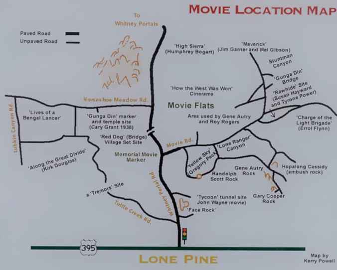
Map of several of the Alabama Hills movie sites
These hills, arches and rock formations on the eastern slope of the Sierra Nevada are in the shadow of Mount Whitney just west of the California town of Lone Pine. Located right off the road to Whitney Portal, the starting point for climbing the 11th highest peak in the United States and the tallest in California, this BLM land is open for exploring, hiking, astronomy, camping and exploring. The formations are part of the same geological formation although geographically separate from the Sierra Nevada Mountains just adjacent to the east


Mines in the area were named after the Confederate Civil War ship the CSS Alabama by sympathetic confederate miners of the time and then it became the name of the entire area. When the Alabama was finally sunk by the USS Kearsarge in 1864 the mining district, a mountain pass and peak and a town were named Kearsarge by sympathetic union miners.
Used by television and movie productions for filming, especially Westerns. Since the 1920’s this rugged environment has been shown in approximately 150 movies and a dozen television shows. A few of the early television shows have been Tom Mix, Hopalong Cassidy, The Gene Audrey Show, The Lone Ranger, and Bonanza. While Gunga Din, The Walking Hills, Yellow Sky, Springfield Rifle, The Violent Men, Bad Day at Black Rock and How the West was Won are some of the Movie Classics. Current Films have included Gladiator, Django Unchained, Iron Man, Man of Steel, Firefly and Tremors.
Nighttime is just as impressive as the landscape during the day as the Alabama Hills is a Bortle Class 2 “average dark sky” site. On a clear moonless night many star formations and the Milky Way appear brightly in the night sky.

Such an interesting sounding place to visit because of all the memories it would bring back from watching the old movies.
LikeLiked by 1 person
It really was and thank you
LikeLike
I’ve been there. Lone Pine is losing a lot of businesses and going downhill, unfortunately, and I don’t think it will improve unless LA lets go of the water and lets the lake refill, ending the dust caused silicosis that kills the locals every year. A fabulous place, though. 395 is an amazing road, and when I was a kid I remember some of the farms still being there, before the water rights were lost entirely. It was pretty. When cars were slower, people stopped more along the way, and all those little towns got visitors, overnight stays, dining options, bait and tackle. There were more fish in the river and lakes. More managed campgrounds, too, so they were family safe and well maintained. They didn’t stink. It was an amazing place, 395, and worth stopping anywhere. So much has changed in four decades.
LikeLike
So very true, 395 is now just a conduit for travelers getting from LA to Mammoth or Tahoe for vacations. Been traveling the road since 1971 and it has changed drastically. From a 2 lane road to mostly 4 now..
Going through Lone Pine on Halloween night I was impressed with Main Street (395) being packed with people and kids as the stores were all open giving away treats for Halloween. People need to slow down and investigate these smaller towns as they still have a lot to offer. Even the old abandoned buildings are interesting. As the old saying goes “Stop and smell the roses”, you’ll still find interesting finds along 395 in these towns.
LikeLike
I went through there last August for a relative’s funeral in LA. It was sad, to see it so run down, so many shops closed. It used to be really vibrant. Its got a great location and views. I’m surprised more people don’t retire there, and the other towns up 395. It gets a steady stream of Snowbirds in RVs and trailers, of course, but while Mammoth is 10x bigger, most of the little towns are gutted by people rushing past, hurrying north or south.
LikeLiked by 1 person
It is so sad that this is happening in smaller towns across our country. People flock to the bigger cities, Tourist destinations.
LikeLike
I agree. I think that water is the crucial problem. Decades ago there was more water along 395, and the towns were more like gardens, and there was better fishing. The last four decades have resulted in poor fishing, abandoned campgrounds, closed restaurants, overpriced resorts and noisy motels, and the small town hominess was lost, replaced by bitter grumps and closed shops. Stuff has changed. I used to enjoy a breakfast at the biggest restaurant in Big Pine, now closed. It ran for a century, and it was cheap. Eggs and toast with burnt hashbrowns for $1.75. The campground there used to have a manager, and the other campgrounds along the route were nice too, with water that worked, cleaner pit toilets, even showers in the best ones. All that is gone because the governor hates small towns, hates the outdoors, and LA doesn’t care to see them funded either. Small towns are dying, and saving the only places worth living requires a lot of expensive modernization, and getting that funding without ruining them with taxes seems beyond their ability. Its a shame. I think until taxes change, and we get a governor who loves wild places, we won’t get these places fixed.
LikeLiked by 1 person