I had just an evening and a few hours the next morning to explore the Alabama Hills. I got in after dark and it was very windy and cold Halloween night so I didn’t want to spend too much time outside. I shall return with more time to explore the Movie Road and Movie Flats to find the locations of the arches and television / movie shooting locations. The Museum of Western Film History in Lone Pine will provide a history and has information and self-guided tours of the area.
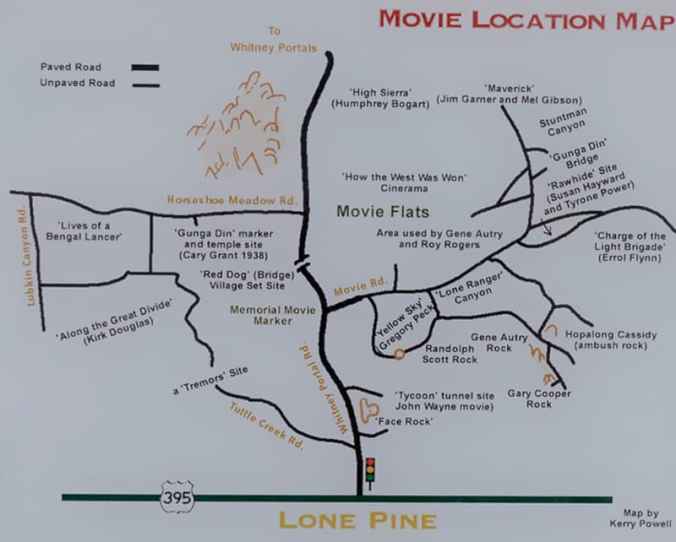
Map of several of the Alabama Hills movie sites
These hills, arches and rock formations on the eastern slope of the Sierra Nevada are in the shadow of Mount Whitney just west of the California town of Lone Pine. Located right off the road to Whitney Portal, the starting point for climbing the 11th highest peak in the United States and the tallest in California, this BLM land is open for exploring, hiking, astronomy, camping and exploring. The formations are part of the same geological formation although geographically separate from the Sierra Nevada Mountains just adjacent to the east
Morning in the desert of Alabama Hills
Morning in the desert of Alabama Hills
Morning in the desert of Alabama Hills
Mines in the area were named after the Confederate Civil War ship the CSS Alabama by sympathetic confederate miners of the time and then it became the name of the entire area. When the Alabama was finally sunk by the USS Kearsarge in 1864 the mining district, a mountain pass and peak and a town were named Kearsarge by sympathetic union miners.
Used by television and movie productions for filming, especially Westerns. Since the 1920’s this rugged environment has been shown in approximately 150 movies and a dozen television shows. A few of the early television shows have been Tom Mix, Hopalong Cassidy, The Gene Audrey Show, The Lone Ranger, and Bonanza. While Gunga Din, The Walking Hills, Yellow Sky, Springfield Rifle, The Violent Men, Bad Day at Black Rock and How the West was Won are some of the Movie Classics. Current Films have included Gladiator, Django Unchained, Iron Man, Man of Steel, Firefly and Tremors.
Nighttime is just as impressive as the landscape during the day as the Alabama Hills is a Bortle Class 2 “average dark sky” site. On a clear moonless night many star formations and the Milky Way appear brightly in the night sky.
I left Vancouver for southern California and my first overnight stop was Lassen Volcanic National Park in northern California. As the name implies it’s major features are volcanic in origin. Being the southern most volcano of the Cascade Range the prominent features of the park are the largest plug volcano in the world, Lassen Peak and it’s sulfur – thermal hot springs.
Originally two separate National Monuments dedicated in 1907 by Theodore Roosevelt, Cinder Cone and Lassen Peak National Monuments were declared Lassen Volcanic National Park in 1916.
I arrived late in the afternoon after an 8 1/2 hour drive and set up camp at Manzanita Lake Campground located in the northern section of the park. Then I proceeded to walk the loop trail around Manzanita Lake, ate dinner and enjoyed a nice campfire before retiring to my tent to read and fall asleep.
Campsite at Manzanita Lake
Manzanita Lake
Manzanita Lake
Manzanita Lake
Evening at the campsite
Accessible by five vehicle entrances the majority of visitors enter either from the north or south along State Route 89, named the Volcanic Legacy Scenic Byway or Lassen Volcanic National Park Highway, off State route 44 in the north and 89 from the south. Three unpaved roads enter the park but do not connect with the main road through the park, Highway 89.
The north-south 29-mile (46.6k) road, Highway 89, was constructed between 1925 and 1931. The road summit is the highest in the Cascades topping at 8,512 feet (2,594 m). This road is closed in the winter months due to snow, which can reach 40 feet (12.2m) deep.
Early morning along the Lassen Volcanic National Park Highway
I got up early, had a quick breakfast and packed up to head south along Route 89 to visit the sites of the park. It was very interesting stopping at the many informative signs along the road to read the history of the park.
The last minor to major eruption started in 1914 and lasted until 1921 creating a new crater on Lassen Peak. Releasing ash and lava it fortunately did not kill anyone. This eruption covered many miles of forestlands with landslides and the new growth forest today stands many feet above the old forest floor. These landslides also created Manzanita Lake as it damned Manzanita Creek.
The first blast was on May 19, 1915 and was said to be a night to remember with it’s steam explosion and subsequent mudflows. Had it not been for Elmer Sorahan many people might have died but he ran 3 miles (4.8k) to warn others after escaping the explosion.
Hot Rock today
Three days later on May 22, 1915 another explosion on Lassen Peak threw ash, pumice, rock and gas into the air that was more devastating to the area than the first. The pressure in the mountain built up like a lid on a boiling pot of water and finally blew. You can now explore this area on a ½ mile (0.8k) loop trail or take the strenuous 2,000 foot (609.6m) 5 mile (8k) round trip hike to the top of 10,457 foot (3,187m) Lassen Peak. Many other hiking opportunities exist in the park along with backpacking, auto-touring, bird watching, camping skiing, skiing, snow play, and snowshoeing.
There are 5 hydrothermal areas to explore within the park. Sulphur Works, Bumpass Hell, Devils Kitchen, Boiling Springs Lake and Thermal Geyser. I am limiting myself to 2 for this trip.
My first hydrothermal area would have been the hike out to Bumpass Hell Hydrothermal Area, a moderate 3 mile (4.8k) round trip hike. This is the largest hydrothermal area of the park with temperatures of up to 322 degrees F (161 degrees C). I had done this hike with my kids back in the early 1990’s although I found the trail closed this season for maintenance of the trail and boardwalk through the 2018 season.
My next stop was Sulphur Works, a formation of mudpots, steam vents and boiling springs located right off the main road. This hydrothermal area in near the center of a massive composite volcano that collapsed many thousands of years ago. Mount Tehama or Brokeoff Mountain was estimated to be 1,000 feet (304m) higher than Lassen Peak. Active 400,000 to 600,000 years ago it is estimated to be nearly 11 miles (17.7k) across and had towered to 11,500 feet (3,505k).
Sulphur Works
Mudpot at Sulphur Works
Brokeoff Mountain from Suphur Works parking lot
My final stop was the Kohm Yah-mah-nee Visitor Center at the south entry of the park to visit the small museum learning the history of the park, peoples and area and had a nice talk with the Rangers.
Now for the long 8 hour drive down the east side of the Sierra Nevada Mountains along State highway 395 to the BLM area of Alabama Hills outside of Lone Pine, CA.
After a restful nights sleep I make a small breakfast, pack up and head out for the short 1-hour drive across the Columbia River into Oregon for a visit to Fort Stevens State Park. Located in the far northwest tip of the state this park is bordered on 1 side by the mouth of the Columbia River and on second side by the Graveyard of the Pacific This 4,300 acre (17.4 sq km) park has much to offer to its visitors; walk or drive along the beach, hike coastal and forested paths, bicycle along bike trails, camp, beachcomb, birdwatch, visit a shipwreck, explore an abandoned military installation used during the Civil War and World War II. Or just relax and enjoy the area.
My first stop was to see one of the shipwrecks along this stretch of the Graveyard of the Pacific. Along with approximately 2,000 other ships since 1792, the remains of the Peter Iredale now rests on the sandy beach. Only a portion of this 275 foot (83.8 m) long steel ship remains, grounded where she came to rest in 1906 from a navigation error in dense fog by its Captain due to the areas treacherous weather and storms. It has become an attraction since the day it grounded on the sandbar.
Graveyard of the Pacific
Peter Iredale shipwreck. Coe photo.
Peter Iredale Shipwreck
Peter Iredale Shipwreck
Peter Iredale Shipwreck
Peter Iredale Shipwreck
Peter Iredale Shipwreck
Next stop was Fort Stevens. First built in 1863-64 during the Civil War it was in use up until the end of World War II, it was part of a 3-fort system at the mouth of the Columbia River to defend this waterway and ports from attack by sea. The other 2 forts were located in the state of Washington; Fort Canby at Cape Disappointment and Fort Columbia a few miles up river from Fort Canby. (For my visit to Fort Canby and Cape Disappointment see LINK)
View of Steam Plant, West Battery and Battery Pratt (from left to right)
Steam Plant Building
West Battery Command Station
View from West Battery Command Station
Replica gun of Battery 245
West Battery from Command Station
Top of West Battery
West Battery
West Battery
Battery Pratt
Replica gun on Battery Pratt
Lower Level of Battery Pratt
Ammunition Hoist inside Battery Pratt
Ammunition storage room inside Battery Pratt
Hoist Mechanism for Battery Pratt
Replica of 200 pound Parrot Rifle
Civil War era Battlemants
10 inch Rodman, smooth bore cannon
Protecting the waterway to the ports of Portland and Vancouver
Protecting the waterway from attack
Battery Smur
View from interior of range Finder Booth
Battery Clark
Inside of Battery Clark
Inside of Battery Clark
Artillery Engineers Room
During World War II a Japanese submarine fired upon Fort Stevens in June of 1942, making this fort notable as being the only military base on the Continental United States to be fired upon by an enemy since the War of 1812. 17 rounds were fired at the fort with no real damage being done.
After a full morning of exploring the buildings and small Fort Stevens Visitors Center – Museum I enjoyed a late picnic lunch and continued my journey south on Highway 101 to visit Ecola State Park. This 9 mile (14.5 k) long stretch of beach lets you enjoy hiking, picnicking, tidepooling, surfing and scenic coastal vistas. Located just north of Cannon Beach, OR I leave Highway 101 and travel the13 miles (21 k) of twisty narrow roadway into the north area of the park to see Indian Beach Day Use Area. This secluded beach is a spot frequented by surfers, beachcombers, and tidepool explorers and is reached along a short path down the hillside to the beach. Extending north is a network of trails that will provide a 2 ½ mile (4 k) loop trail to the top of Bald Mountain or continue north to Tillamook Head trailhead which is part of the Oregon Coast Trail. The loop trail is part of the Lewis and Clark National Historic Tail, walked by Lewis Clark and a band of men from the Corps of Discovery to search for a beached whale in 1806. They were hoping to return to Fort Clatsop with whale blubber as they fought hunger from their time there. They sadly return empty handed.
View from above Indian Beach, Ecola State Park
View from above Indian Beach, Ecola State Park
View from Above Indian Beach, Ecola State Park
Peaceful Indian Beach, Ecola State Park
Indian Beach, Ecola State Park
Indian Beach, Ecola State Park
Indian Beach, Ecola State Park
After this beautiful day of exploring I returned to my car and drove the 2 hours back to my home to plan the next trip in a few weeks, south to visit my family and friends at the home I just moved from.
Named by Captain John Meares’ 1778 disappointing sailing to find the mouth of the Columbia River for trading. Being turned away by a severe storm, he named this place Cape Disappointment. While in complete contrast Lewis and Clark’ s Corps of Discovery cheered as they completed their journey with their first sight of the Pacific Ocean on a bluff on Cape Disappointment.
Cape Disappointment State Park is far from being a disappointment. Steeped in Northwest history, it is a place to explore U.S. military and maritime installations, learn more of Lewis & Clark’s Corps of Discovery Expedition and their effects on native tribes of the area. Camp, fish, hike old-growth forests, roam around freshwater lakes, saltwater marshes and ocean tidelands. Marvel at the breathtaking views from the highlands above the sea and wander the beaches that are enjoyed by kite-fliers, beachcombers, sandcastle builders and those who just love to walk. Hike to 2 lighthouses that guided the mariners to the mouth of the river and kept them from becoming victims of the Grave Yard of the Pacific.
I began my day at the Lewis and Clark Interpretive Center and one of the Battery’s of Fort Canby that defended the entrance to the Columbia River from the mid 1900’s to the end of World War II. The Interpretive center is a museum providing a history lesson of The Corps of Discovery’s journey from settled America along the Mississippi River to the Pacific Ocean. Walk along the history path in its interactive exhibits that will entertain all ages. Sitting right above Battery Harvey Allen of Fort Canby to the inland side and overlooking the Pacific Ocean from its cliff side perch it is a wonderful place to start your visit to the park.
Battery Harvey Allen
Battery Harvey Allen
Battery Harvey Allen
Battery Harvey Allen
Battery Harvey Allen
Battery Harvey Allen
Battery Harvey Allen
Off to the south from the ocean-viewing platform of the Interpretive Center you see Cape Disappointment Lighthouse. Start the hike to the lighthouse in the Interpretive Center’s parking lot. You’ll walk through dense forest glimpsing ocean and river views as you make your way to the oldest operating lighthouse in the Pacific Northwest. Built in 1856 to warn the ships of the treacherous currents and obstacles of the river bar at the mouth of the river.
Cape Disappointment Lighthouse
On the walk to Cape Disappointment Lighthouse
On the walk to Cape Disappointment Lighthouse
Cape Disappointment Lighthouse
View of the mouth of the Columbia River from Cape Disappointment Lighthouse
Continuing on driving I thought I made a very wrong turn as I saw a sign for Waikiki Beach. It is a short ¼ mile (0.4 k) walk to the beach. It was still overcast when I visited although I suspect it would be a nice place for a picnic lunch and to watch the waters and vessels of the Columbia River float past.
Continuing my exploration of the park I stopped a short time later at the trailhead to Battery 247 that is perch on a hill in a strategic location overlooking both the Pacific Ocean and the Columbia River. Very deteriorated and overgrown it is an interesting structure to wander through. Although being small I recommend bringing some type of flashlight or headlamp to go deeper into the underground ammunition building. This is also the area where Lewis and Clarks Corps of Discovery first laid eyes on the Pacific Ocean.
Battery 247
Battery 247
Battery 247
Following the road a little further leads me to the campground. I wish to see if I wanted to spend the night here. I found it to be a nice place right along the ocean and went back to the entry station to reserve a site for the night. I wanted a quiet spot to relax for the night so selected site #157. My site is not right along the beach, although a few are, but only 200 yards (183 m) away. In this group of 9 campsites there were only 2 other sites being occupied.
Campsite for the night at Cape Disappointment Campground
Having settled my accommodations for the night I drove up to North Head Lighthouse to walk the pathway to the base of the lighthouse. This second lighthouse was built as the Cape Disappointment Lighthouse left a section of coast unprotected from a mariner’s point of view. Built 190 feet (60 m) above sea level in 1898 this 65’ (19.8 m) tall lighthouse is still functioning and maintained by the U.S. Coast Guard. This is located on one of the windiest places along the west coast with recorded winds of up to 120 MPH (321.9 km/h).
North Head Lighthouse
North Head Lighthouse
Finished for the day I returned to set up camp and have a snack before I took a walk along the beach outside my temporary front door. The beach was an easy walk although exploring higher up the high tide line finds many logs that have been deposited along the beach during the severe storms coming in off the Pacific. Many small windbreak structures have been built by visitors add to the cozy feel of the beach.
Storm tossed logs at Cape Disappointment Campground Beach
Storm tossed logs at Cape Disappointment Campground Beach
Storm tossed logs at Cape Disappointment Campground Beach
Visitor made wind breaks at Cape Disappointment Campground Beach
Cape Disappointment Campground Beach
Deciding to go back and grab my camera tripod, I return to the beach to watch the sun setting in the west. After a wonderful rest and watching a beautiful sunset I proceed back to my camp, fix a small dinner and climb into the tent early to do a little reading then to fall asleep listening to the waves crashing into the shore.
Sunset from Cape Disappointment Campground Beach
Sunset from Cape Disappointment Campground Beach
I will return here again to continue exploration of the trails in the area. The 1.5 mile (2.4 k) Coastal Forest Loop trail, Bell’s View Trail, the 1.5 mile (2.4 k) long North Head Trail and the south portion of the coastal Discovery Trail will be on the short list of walks.
I continue my journey in the morning crossing back into Oregon to visit Fort Stevens then head a little further south to see another fantastic beach.
This National Historic Site has a long history on the north bank of the Columbia River, starting as a Hudson Bay fur trading post. The Park is a collection of 4 distinct sites, Old Fort Vancouver, The Village, Pearson Air Field and Vancouver Barracks, each having a history of transition, settlement, manufacturing and conflict.
“Old Fort Vancouver”, visited before (LINK) which I will discussed more in a future post, was established around 1825 by the Hudson Bay Company. Serving as the main headquarters of the Company’s interior fur trade from Russian Alaska to Mexican California and everything west of the Rocky Mountains.
Reconstructed Old Fort Vancouver
“The Village” provided the area for housing the workers and their families who supported Fort Vancouver. Established in 1829 it had a population exceeding 600 and was one of the largest settlements in the west at that time.
The Village of old Fort Vancouver
Reconstructed homes of the Village of old Fort Vancouver
Reconstructed homes of the Village of old Fort Vancouver
“Pearson Air Field” first used the Polo Field of the Vancouver Barracks as a site for aviation enthusiasts to gather and show off their aerobatic skills in the early years of the 20th century. During World War I a Spruce Production Mill was built on the Polo Field to supply aviation grade lumber in the manufacturing of war planes. After the war the Spruce Mill was removed and “Vancouver Barracks Aerodrome” was built, in 1925 it was christened “Pearson Air Field,” after Lt. Alexander Pearson. I will go into more detail of this part of the Park in a future post.
Well plans have totally changed, during the last part of July right before I was to leave on my Northern Adventure. My daughter, my grandson, 13 and granddaughter, 10 were going to move out of the house so I decided to sell my home of 27 years and move north. She really wanted and loved the family home so it was agreed she would buy the home and the transaction was a go without the house ever going on the market.
That changed my plans drastically.
I reviewed my future and decided to move up the relocation to the Pacific Northwest to be by my son, daughter-in-law, 3 YO grandson and the new addition that was due in a couple of weeks. Well, going on this travel adventure and relocating 1,000 miles (1,610 k) away within a couple of months was too much for me to handle. So the Adventure would have to wait a year.
Leaving the beginning of August I traveled north to stay with my son and family while waiting on the new little one to be born. I started looking for homes and exploring the area the day after I arrived.
My daughter-in-laws family wanted to go out with kayaks on Lacamas Lake the next day, so off we went. It was a wonderful morning paddling around on this 3-mile (4.8k) long lake.
Kayaking Lacamas Lake, WA
Kayaking Lacamas Lake, WA
Kayaking Lacamas Lake, WA
Kayaking Lacamas Lake, WA
Next up was a loop walk down to the Columbia River then exploring Fort Vancouver National Historic Site. I will cover this walk in my next post as it deserves it’s own post.
BarraParade Grounds, Fort Vancouver National Historic Site
Later in the week I went for a pleasant morning 4-mile (6.4k) walk around Round Lake, a wonderful area with many hiking trails, trees, waterfalls and streams. I went home to relax and in the afternoon started looking at homes in the area.
Walking around Round Lake, WA
Round Lake, WA
Dam machinery at Round Lake, WA
One day out of the blue we visited this wonderful home located in a pocket of pines, I really loved this place and it reminded me of a cabin that I had once owned in Lake Arrowhead, CA. My son and daughter-in-law basically said I should put an offer in right away or they might buy it, LOL. The next day I put my offer in and after a little negotiating it was to be mine.
A few days later a beautiful baby boy was born.
New addition
Three generations
What an exciting and unexpected time I had in those few weeks. Instead of heading into the great white north after the birth of my grandson, the plans suddenly changed with the selling my home, exploring some beautiful areas, buying a new home and being there for my forth grandchild’s birth.
Well now to make the drive back south and start packing up for the move. That’s going to be a massive amount of work.
All right my trip is getting closer and I’m in the final stages of preparation. Vehicle is ready just needs final fluid changes before leaving. Camping gear is waiting. GPS route is set and just the final tweaks and additions are being done.
Will be leaving Southern California on July 9th heading to Vancouver, WA along Highway 395 for the birth of my 4th grandchild. Leaving Vancouver I will head to Glacier National Park, Banff and Jasper National Parks in Canada then start the northern push to Dawson Creek, B.C. and start the drive there at Mile-marker Zero on the Alaskan Highway (Al-Can to us older folks) to Watson Lake, Yukon.
Turning off the Alaskan Highway at Watson Lake I’ll be on Canadian 4, a gravel road, to make my swing to Dawson, Yukon and the Arctic ocean at Tuktoyaktuk, Northwest Territories. At this, my furthest point north, I start my swing back to Dawson and turn west to continue along the Top of the World Highway to Tok, Alaska.
Leaving Tok I will go south on the Alaskan Highway to Haines Junction and continue to Haines, Alaska along the Haines Highway to ferry across to Skagway and head back to the Alaskan Highway along the South Klondike Highway. I will leave the Alaskan Highway just before Watson Lake and turn south onto Canadian 37, The Cassier Highway, to Prince George, BC. From there I will continue south along Canadian 97 making my way back to the border and return to Vancouver, WA to visit my new grandchild before returning home south along Highway 101.
I have found during research a great resource for the area called, “The Milepost”. this details the Alaskan Highway and side-routes in Alaska, British Columbia, the Yukona nd Northwest Territories. I also picked up a camping guide named “Traveler’s Guide to Alaskan Camping” that includes all the Alaskan Highway and the same side-routes in it’s pages. Although this book was written for RV’s in mind it is good source for me, tent camping, to hit some campgrounds with services such as WIFI, showers, and laundry facilities along the way. It ranges from private, to Provincial Parks, to free camping areas along the roads.
Well I am heading back out to Bickel Camp, Burro Schmidt Tunnel and a ranger led hike into Nightmare Gulch in Red Rock Canyon State Park for a fundraiser to help offset expenses on the upkeep of Bickel Camp.
Bickel Camp is full of mining equipment on display at this historic 1930’s era mining camp. The camp is still there to be visited by the adventurist explorer. Luckily this has remained on the “Adopt-A-Cabin” program and there is a caretaker on site to help explain and protect the remaining historic artifacts. Donations to help preserve and maintain the site are appreciated. 2 of Walter Bickel’s granddaughters were there walking us around the camp and telling of the fun they had out here when they visited. They told us one story of Bickel finding a stranded motorist in the desert and helped him get unstuck, turned out it was Jimmy Durante. Another interesting fact was that both Bickel and Schmidt were in the service during WWII, living within sight of one another they had a strong friendship and even rigged up automobile headlights so they could send messages back and forth in Morris Code. And yes the light at Bickel Camp is still standing.
For a full history on this wonderful place to visit follow this LINK.
Bickel Camp
Bickel Camp
Listening to the tales of Bickel Camp
Bickel Camp Equipment
Bickel Camp Equipment
Bickel Camp Equipment
Bickel Camp Equipment
Bickel Camp Equipment, tractor radiator
Bickel Camp Equipment
Bickel Camp Equipment
Bickel Camp Equipment
Bickel Camp Equipment
Bickel Camp Equipment, nice old Datsun 1600
Bickel Camp Equipment
Bickel Camp Equipment, old refrigerator anyone
Bickel Camp Equipment, homemade table saw
Bickel Camp Equipment has been here a long time
Bickel Camp Equipment
After wandering around the camp and being entertained by first hand stories from the granddaughters we all head the few miles down the trial to Burro Schmidt’s Tunnel to explore the hand-drilled tunnel nearly a half-mile long that was dug with a single 4-pound jackhammer, and dynamite.
For additional information see my previous post LINKED HERE.
Walking through Burro Schmidt’s Tunnel
Exiting Burro Schmidt Tunnel on the south side
Next up it was to find our way back to asphalt and turn south into Red Rock Canyon State Parkand the hike into Nightmare Gulch. We all meet-up for a short lunch stop at a park rest area before heading out the dirt road to the trail head. Although we did not do the loop we drove as far as we could to the official trail head and took a 5-mile total out and back hike into the canyon. Led by 3 Bureau of Land Management rangers we were given lessons in history, geology and ecology of this area. It was a great hike and took most of the afternoon.
Trail to Nightmare Gulch
Nightmare Gulch
Trail to Nightmare Gulch
Nightmare Gulch
Ranger led hike at Nightmare Gulch
Ranger led hike at Nightmare Gulch
Nightmare Gulch
Nightmare Gulch
Nightmare Gulch
Nightmare Gulch
Nightmare Gulch
Nightmare Gulch
Nightmare Gulch
Nightmare Gulch
Nightmare Gulch
Nightmare Gulch
Nightmare Gulch
Nightmare Gulch Pano
Leaving the trail head at about 4:30PM I still had a 3 hour drive home. Arriving home at 7:50 PM I was exhausted as I got up at 3AM to get there and meet someone at the turnoff to the Camp. This adventure was wonderful as I met new adventurers and discovered this magnificent canyon that I will return to to follow the entire loop trail.
Well we plan another easy day as it’s getting late in the trip and I think we are all tired from all the visiting and traveling that has been done. Today it was decided to go to a nature reserve for a short drive and walk, as the weather is finally getting rainy. Imagine that, rainy weather in the Pacific Northwest during winter.
This 5,150-acre (2,084 ha) area of marshes, grasslands and woodlands, named the Ridgefield National Wildlife Reserve is just north of Vancouver, WA and is one of 4 reserves located along the Columbia River in the greater Vancouver area. Established in 1965 to protect waterfowl, it was established with the 3 other refuges in the Willamette Valley for wintering birds migrating and nesting from Alaska.
The area includes a 2-mile (3.2 k) self-guided walking trail that’s objective is to showcase the Columbia River Watershed, the 4.2-mile (6.75 k) auto tour route and a seasonal 1.2-mile (1.9 k) hiking trail.
Managed by the U.S. Fish and Wildlife Service it protects sandhill cranes, various shorebirds, and a large variety of songbirds, mallards, great blue herons, and red-tailed hawks. Mammals calling the reserve home include deer, coyote, raccoon, skunk, beaver, river otter, and brush rabbits.
Ridgefield National Wildlife Reserve
Ridgefield National Wildlife Reserve
Ridgefield National Wildlife Refuge
Great Egret
Canadian Geese
Hawk
White Tail Deer
River Otter
The refuge consists of five sections, each unique in habitat supporting the wildlife that reside there. Two of these sections are open to public visitation and enjoyment, while the remaining three are kept as sanctuary for wildlife to rest, nest and escape human disturbance. This maintains an important balance for those species less tolerant to human presence to thrive in an increasingly urban area. The visitors then get the chance to view and experience wildlife and habitat, receiving the many benefits of being out in nature.
The Columbia River has long sustained human population and dates back long before Euro-American arrived. There have been large Native American settlements found on the reserve. The refuge also preserves the most intact archaeological site on the lower Columbia River with evidence of at least 2,300 years of continuous human occupation. That history and culture is interpreted through the Cathlapotle Plankhouse built in 2005 and open to visitors on the weekends in the spring and summer. The plankhouse was built to represent the buildings Lewis and Clark might have found here at their Wapato Portage village.
Since we are visiting in January we are not to leave the car due to the large flocks of geese and ducks nesting in the area between October 1st and April 30th. The cars become your movable animal blind as the birds are accustomed to the vehicles presence. There is an observation blind halfway along the route you can park and take the short hike out to it.
On the walk to the blind
On the walk to the blind
On the walk to the blind
From the blind of the Ridgefield National Wildlife Reserve
From the blind of the National Wildlife Reserve
There are 14 interpretive markers and signs along the way along the one-way road. It was a fun drive as we were one of the few vehicles in the reserve on this weekday morning. We saw many birds, mammals and 2 deer along our route. When we left the car to hike to the blind my grandson had an old cell phone that he uses to take photos and he was just shooting away at all the details on the forest floor trying be like his Dad, it was so cute.
It has been a tiring week of visiting family, meeting new people and seeing new sights so we leave at lunchtime to head home for a late lunch as I need to pack and rest for my drive home.
We take a day to rest, clean and organize our things from the adventure at Tillamook State Forest then decide to head north from Vancouver, WA for a day trip to Battleground Lake to enjoy the nature surrounding it. Being winter it is raining off-and-on today, so we go down to the lakeshore so my grandson can have some fun trying to fill the lake with rocks he finds on the shoreline. This is something he really enjoys, he has thrown rocks at Mt Adams, into the Snake River in Grand Teton National Park and now here. Kids are so funny how they entertain themselves. We discussed hiking the trail that goes around the lake but decided that with the rain it would just be a slick mess.
Cedar Creek Grist MIll and Cedar Creek
Cedar Creek Grist Mill and bi-pass overflow falls.
After our short stay at the lake we head to The Cedar Creek Grist Milljust outside Etna south of the Lewis River along scenic Cedar Creek. A gristmill grinds grain into flour using nature’s forces, usually water being run by a water wheel. The first water-powered mill was reported around 71 BC in Asia Minor. Grain mills in England were counted in the 1086 Domesday Survey In England, which stated there were 5,624, or about one for every 300 inhabitants that year, peaking to 17,000 by 1300.
Cedar Creek Grist Mill is a working museum allowing visitors inside to observe the workings of the mill built in 1876. Samples are given to visitors after the tour of the facility. This is a totally nature driven mill using the water flowing through a plumb to a Leffel turbine installed with its flume (water canal) around 1888. Pulleys, and belts turn the milling stone producing flour, corn meal and sometimes apple cider.
Flume and Cedar Creek
Flume and Cedar Creek
Flume and Cedar Creek
Flume and Cedar Creek
Flume and Cedar Creek
Leffel turbine
Leffel turbine
Resting on a steep and rocky slope in the narrow gorge of Cedar Creek, it is the only gristmill in Washington that still maintains its original structure, mills with stones, and is water powered, this is also the oldest building in Washington State still producing its original product.
Debri along the creek
some of the lush ferns along the creek
Tossing rocks into Cedar Creek
The last owner died in the late 1950’s and the property was bought by The State Fisheries Department in 1961 that removed the old dam and built a fish ladder. The Fort Vancouver Historical Society leased the mill in 1961 and had it registered as a National Historical Place.
Time, weather and vandals took its toll by 1980. “The Friends of the Cedar Creek Grist Mill”, a non-profit corporation, was formed to save the old mill. Using period tools consisting of axes and adzes they replaced the damaged posts and beams. Due to a dam removal in 1961 they had to now get water into the mill, extending the flume 650 feet where the water from the creek could flow into the intake without the dam.
Next to the mill is a covered bridge across Cedar Creek. There is no history on the first bridge although it was completely replaced by a truss bridge in 1935. The 1935 bridge could not support heavy loads, so in 1994 a new covered bridge spanning Cedar Creek was built.
1994 covered truss bridge
Standing on the covered bridge
Sadly it was closed on this weekday right after the holiday but peeking in the windows demands a return visit when it is open.


You must be logged in to post a comment.