On a little adventure to Wyoming: National Historic Trails Interpretive Center; Casper, Wyoming

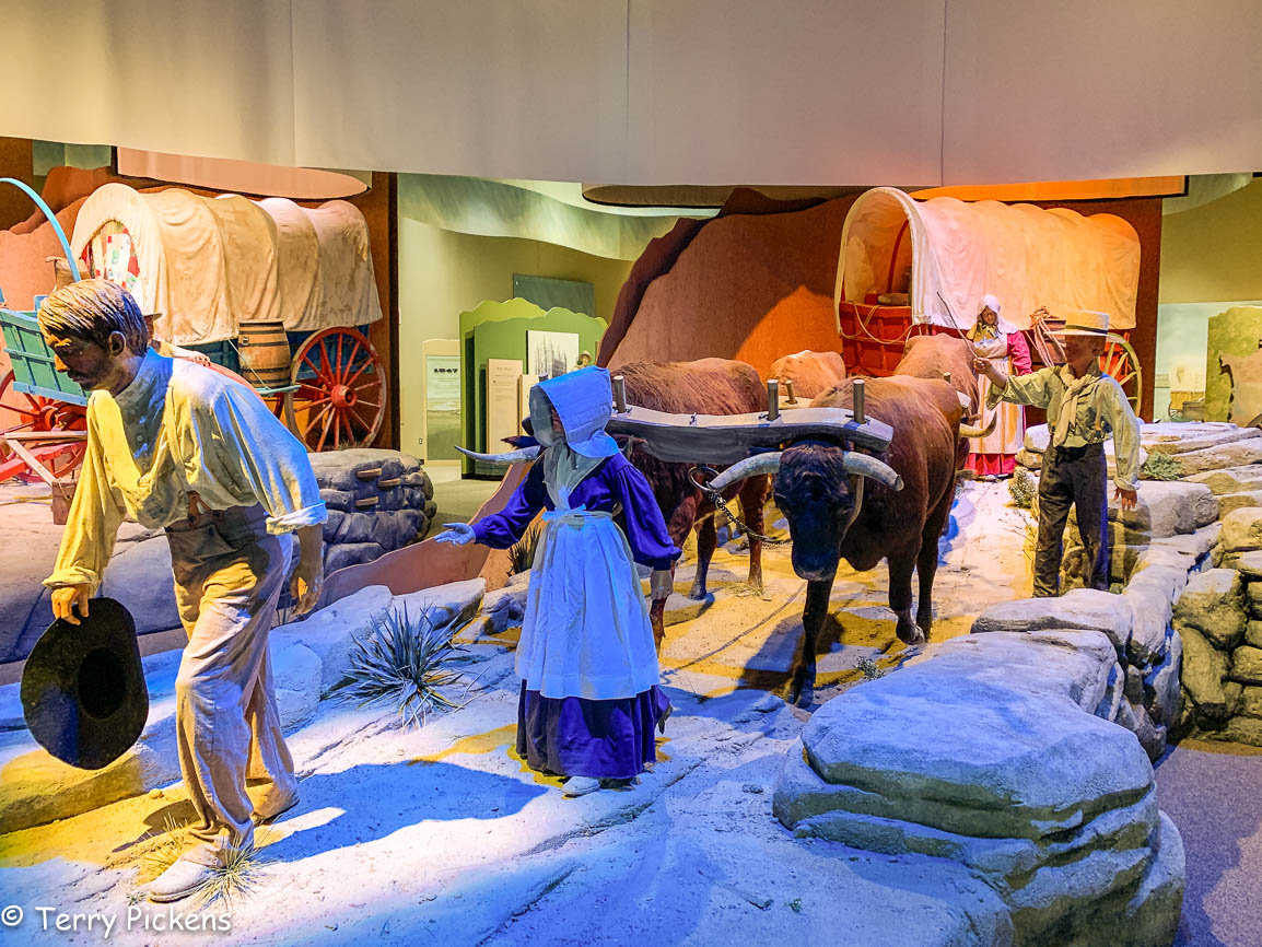
“Some men walked with whips to drive the team of animals puilling the wagon or to herd the stock. Many emigrants brought with them sheep, pigs, and cows to provide fresh meat and milk during the long journey.”

We hear of the Tiny House movement now but never think how the pioneers had to weed out all the unnecessary items of their former life for a life of hardship on the 2,170-mile (3,490 km) journey that lasted approximately 4 to 6 months and if started in the wrong season, longer. These men, women and children not only carried their personal belongings in their wagon or cart but also food and wagon parts. There were not many stores or trading posts along the perilous route. Most had no room in the wagons to sleep so they slept on the ground under the wagons or in tents.

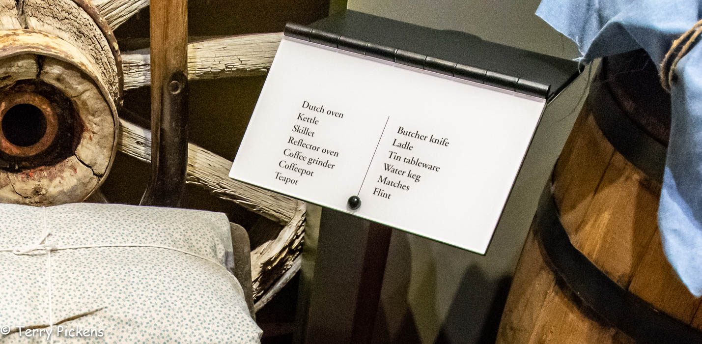
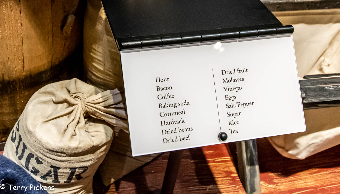
According to the 1863 handbook “The Prairie Traveler” by Captain Randolph B. Marcy they should carry: Wrought Iron camp kettle, large enough for boiling meat and making soup; a coffee pot and cups of heavy tin, with the handles riveted on; tin plates; frying and bake pans of wrought iron, the latter for baking bread and roasting coffee; a pan of heavy tin or wrought iron for mixing bread and other culinary purposes; knives, forks and spoons; an extra camp kettle; tin or gutta percha (gum tree) bucket for water – wood being liable to shrink and fail to pieces is not deemed suitable; an axe; hatchet; a spade, mallet and matches; extra parts for the wagons such as covered tar buckets for tar, resin and grease; two bows, six “S”-hooks; a king bolt and wagon other supplies.

“When you start over these wide plains, let no one leave dependent on his friend for anything; for if you do, you will certainly have a blow-out before you get far.” – John Shively, 1846

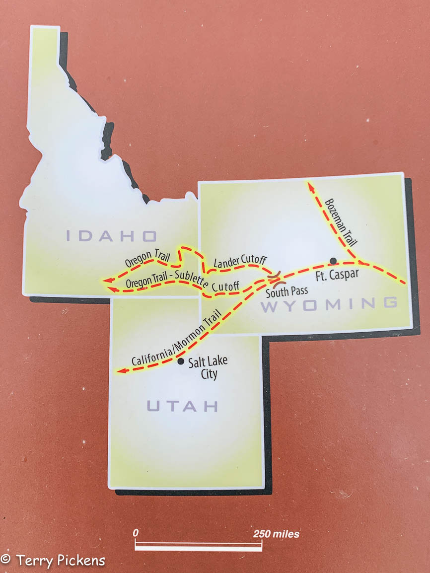
The Westward Pioneer Trails in the north consisted of the Oregon, Mormon, California and Pony Express Routes which passed through Casper, Wyoming on their way west. Casper had in place a military presence at a garrison , a trading post and some settlers. At this point settlers heading to California and Oregon had only completed one third of their journey, while the Mormons bound for Salt Lake City, Utah had completed half of theirs. But crossing the Platt River at this location they faced a perilous crossing either by fording the river and possibly losing their wagon and animals or by paying as much as $5 per wagon to cross by ferry or bridge, a fortune back in the mid 1800’s.

Visiting this 11,000 S.F. (1,000 m2) Museum you will be able to discover what life was like on the Oregon, California, Mormon and Pony Express Trails that brought settlers to the west coast in covered wagons and hand pulled carts. With 8 galleries, temporary exhibits and an 18-minute multimedia film, “Footsteps to the West” that explains the trials and tribulations of life along the trail in the theater. 

Allow 1-2 hours to understand what hardships these pioneers faced. The museum contains hands on exhibits for all ages:

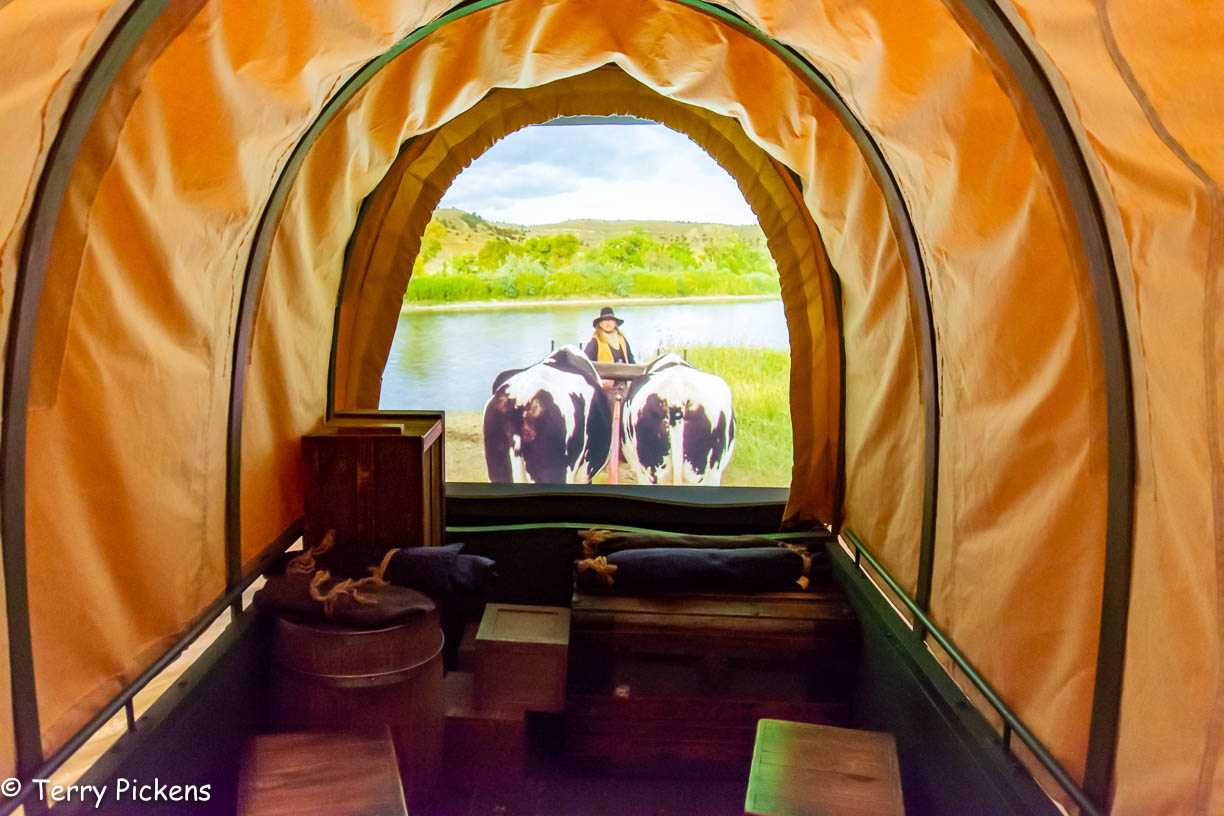
you can sit in a covered wagon as it bounces across a river; 

pull a loaded Mormon Cart to see how difficult it was; 

Mormon Handcart

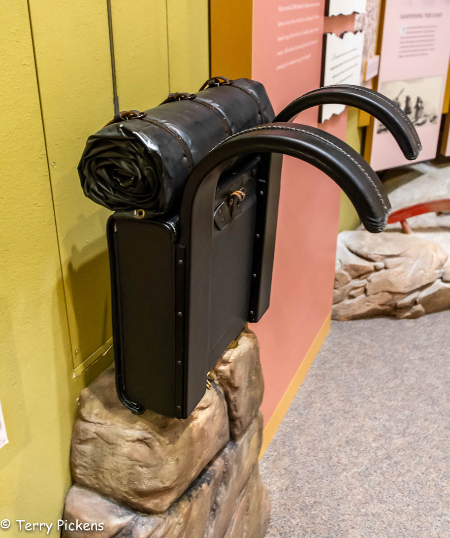
sit in a replica stagecoach; feel how heavy a backpack loaded with supplies that the pioneers carried as they walked across the plains on foot;

determine what is needed for the journey west;

see how they calculated miles;

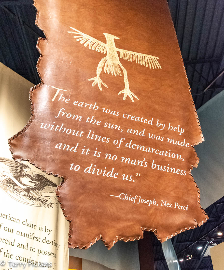
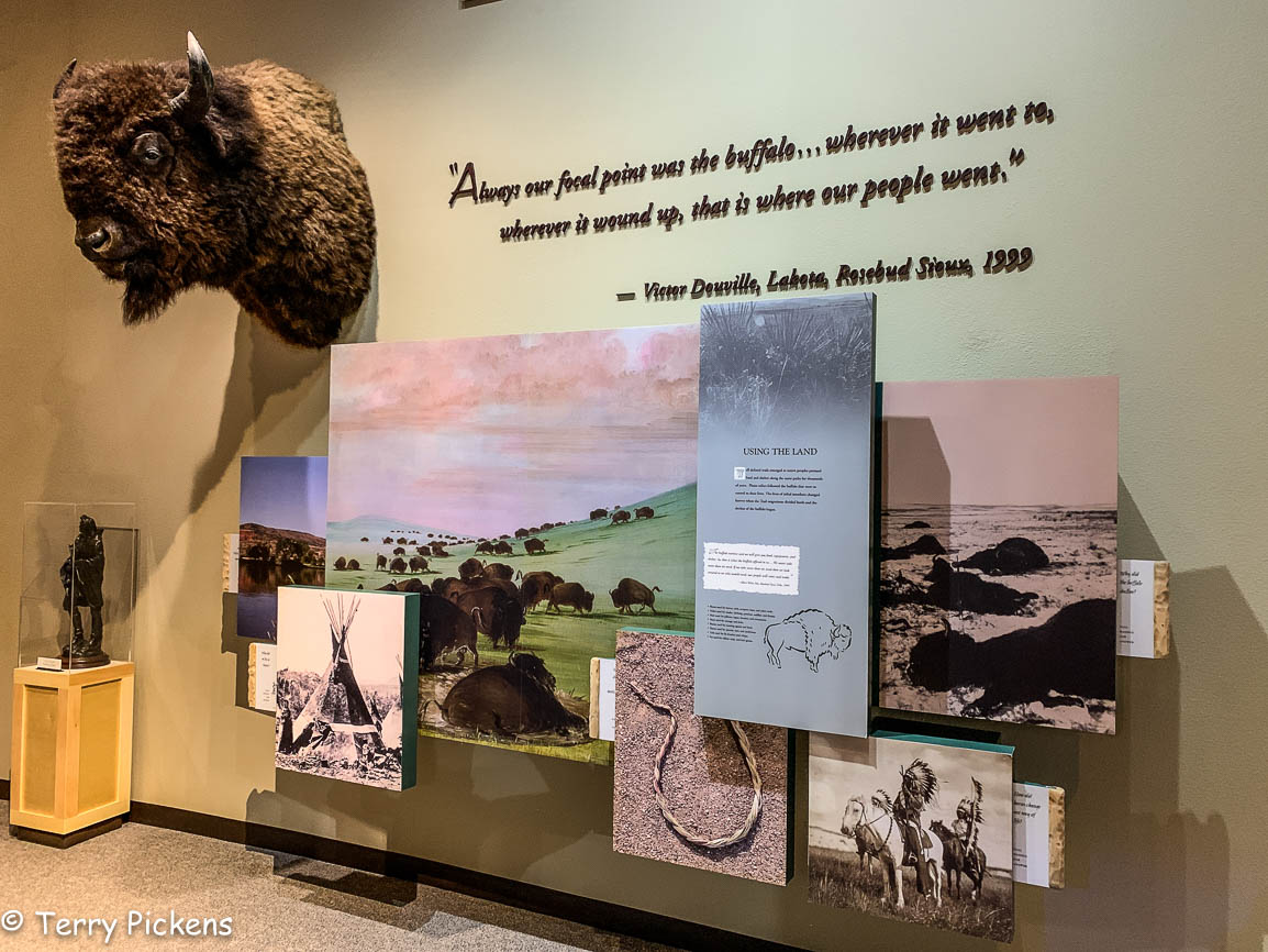
Learn a bit of the native cultures and their way of life on the prairie;

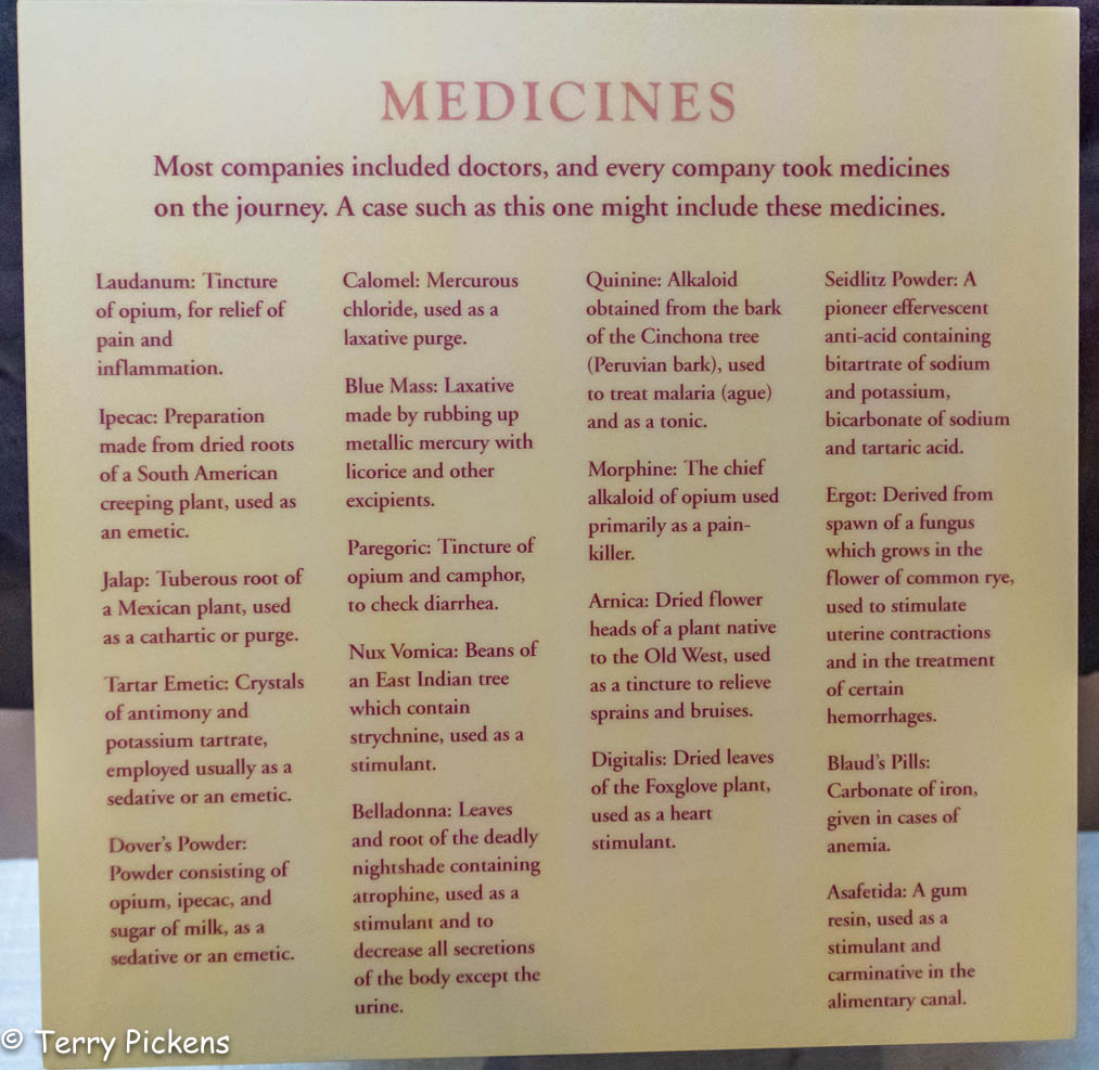
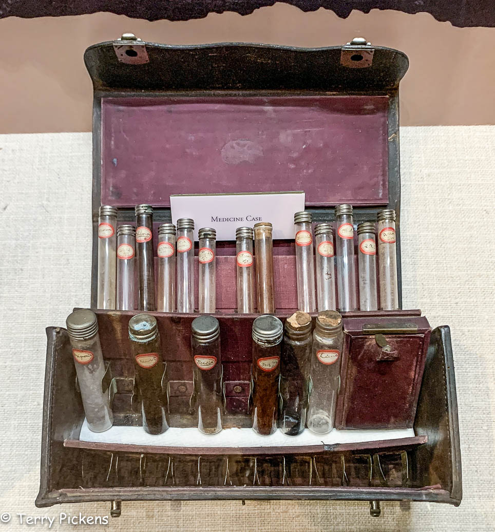
 See the medicines that were taken on the trail;

And many more hands-on displays that capture the real-life adventure of over 400,000 settlers between 1841 and 1868.

Opening August 9, 2002 and operated by the Bureau of Land Management it was a joint private and public partnership with the BLM, the National Historic Trails Foundation and the City of Casper, Wyoming commemorating Native American History, early explorers and the Trails corridors.

This is a free museum to enter but I highly recommend if you enjoy your visit please leave a donation at the entry to help offset the cost of maintenance and for future upgrades. I found staff and volunteers were all helpful and friendly on the day of my visit. Take the time to talk to them, they have knowledge of the area and local events. If you are interested in local and early American History this is a nice place to visit.

Day 1 – The first push from Vancouver, WA

Planning this adventure has been a 2 year ambition of mine. Last year life got in the way of the trip so this year it was a go. I got some interest from a few people that would like to tag along and one did show up at my house the day before departure.

Leaving early to get through the Sunday morning Seattle traffic the first stop will be the border crossing into Canada. After an easy crossing at the border we headed toward Abbotsford, British Columbia  going north on BC 11 to Canadian Hwy 1.

The first section of the journey follows Canada Hwy 1 and the Frasier River. A 20-mile section of this road also includes 7 tunnels you must pass through.

Stopping at Hells Gate we elect to walk the 35 minutes down into the canyon instead of taking the Aerial Tram (Gondola). This abrupt narrowing of the river is located just downstream of Boston Bar. The rock walls of the river plunge toward each other forcing the waters through a passage only 35 meters (115 ft) wide.

The narrow passage has been a fishing ground for Local Native communities in the area for centuries. European settlers began to congregate there in the summer months to fish. This canyon became a route used by fortune seekers of Gold Rush miners accessing the upper Fraser gold-bearing bars and the upper country beyond. It was a dangerous passage where canoes didn’t dare its rapids. Ladders and shelf roads were constructed to get around its treacherous waters. Only one Sternwheeler successfully manuvered through this section of the canyon.

Continuing on Canadian 1 for a short time we decided to stop at Goldpan Provincial Park for the night. Finding a campsite along the river makes for an ideal location for the nights camp. After eating dinner it’s a short walk to the water to sit on the back with feet in the cool water and watch the sun set behind the mountain.

And this is what was heard in the tents all night long, what a sweet background noise to lull you into slumber.

Alabama Hills, Lone Pine, CA

I had just an evening and a few hours the next morning to explore the Alabama Hills. I got in after dark and it was very windy and cold Halloween night so I didn’t want to spend too much time outside. I shall return with more time to explore the Movie Road and Movie Flats to find the locations of the arches and television / movie shooting locations. The Museum of Western Film History in Lone Pine will provide a history and has information and self-guided tours of the area.

Alabama-Hills-Movie-Location-Map

Map of several of the Alabama Hills movie sites

These hills, arches and rock formations on the eastern slope of the Sierra Nevada are in the shadow of Mount Whitney just west of the California town of Lone Pine. Located right off the road to Whitney Portal, the starting point for climbing the 11th highest peak in the United States and the tallest in California, this BLM land is open for exploring, hiking, astronomy, camping and exploring. The formations are part of the same geological formation although geographically separate from the Sierra Nevada Mountains just adjacent to the east

Mines in the area were named after the Confederate Civil War ship the CSS Alabama by sympathetic confederate miners of the time and then it became the name of the entire area. When the Alabama was finally sunk by the USS Kearsarge in 1864 the mining district, a mountain pass and peak and a town were named Kearsarge by sympathetic union miners.

Used by television and movie productions for filming, especially Westerns. Since the 1920’s this rugged environment has been shown in approximately 150 movies and a dozen television shows. A few of the early television shows have been Tom Mix, Hopalong Cassidy, The Gene Audrey Show, The Lone Ranger, and Bonanza. While Gunga Din, The Walking Hills, Yellow Sky, Springfield Rifle, The Violent Men, Bad Day at Black Rock and How the West was Won are some of the Movie Classics. Current Films have included Gladiator, Django Unchained, Iron Man, Man of Steel, Firefly and Tremors.

Nighttime is just as impressive as the landscape during the day as the Alabama Hills is a Bortle Class 2 “average dark sky” site. On a clear moonless night many star formations and the Milky Way appear brightly in the night sky.

My visit to Lassen Volcanic National Park on a trip south to visit family.

Lassen_Volcanic_National_Park_map

I left Vancouver for southern California and my first overnight stop was Lassen Volcanic National Park in northern California. As the name implies it’s major features are volcanic in origin. Being the southern most volcano of the Cascade Range the prominent features of the park are the largest plug volcano in the world, Lassen Peak and it’s sulfur – thermal hot springs.

7-2


Originally two separate National Monuments dedicated in 1907 by Theodore Roosevelt, Cinder Cone and Lassen Peak National Monuments were declared Lassen Volcanic National Park in 1916.

0-0

I arrived late in the afternoon after an 8 1/2 hour drive and set up camp at Manzanita Lake Campground located in the northern section of the park. Then I proceeded to walk the loop trail around Manzanita Lake, ate dinner and enjoyed a nice campfire before retiring to my tent to read and fall asleep.


Accessible by five vehicle entrances the majority of visitors enter either from the north or south along State Route 89, named the Volcanic Legacy Scenic Byway or Lassen Volcanic National Park Highway, off State route 44 in the north and 89 from the south. Three unpaved roads enter the park but do not connect with the main road through the park, Highway 89.

The north-south 29-mile (46.6k) road, Highway 89, was constructed between 1925 and 1931. The road summit is the highest in the Cascades topping at 8,512 feet (2,594 m). This road is closed in the winter months due to snow, which can reach 40 feet (12.2m) deep.

0-4

Early morning along the Lassen Volcanic National Park Highway


I got up early, had a quick breakfast and packed up to head south along Route 89 to visit the sites of the park. It was very interesting stopping at the many informative signs along the road to read the history of the park.


The last minor to major eruption started in 1914 and lasted until 1921 creating a new crater on Lassen Peak. Releasing ash and lava it fortunately did not kill anyone. This eruption covered many miles of forestlands with landslides and the new growth forest today stands many feet above the old forest floor. These landslides also created Manzanita Lake as it damned Manzanita Creek.

The first blast was on May 19, 1915 and was said to be a night to remember with it’s steam explosion and subsequent mudflows. Had it not been for Elmer Sorahan many people might have died but he ran 3 miles (4.8k) to warn others after escaping the explosion.


Three days later on May 22, 1915 another explosion on Lassen Peak threw ash, pumice, rock and gas into the air that was more devastating to the area than the first. The pressure in the mountain built up like a lid on a boiling pot of water and finally blew. You can now explore this area on a ½ mile (0.8k) loop trail or take the strenuous 2,000 foot (609.6m) 5 mile (8k) round trip hike to the top of 10,457 foot (3,187m) Lassen Peak. Many other hiking opportunities exist in the park along with backpacking, auto-touring, bird watching, camping skiing, skiing, snow play, and snowshoeing.

There are 5 hydrothermal areas to explore within the park. Sulphur Works, Bumpass Hell, Devils Kitchen, Boiling Springs Lake and Thermal Geyser. I am limiting myself to 2 for this trip.

4-4

My first hydrothermal area would have been the hike out to Bumpass Hell Hydrothermal Area, a moderate 3 mile (4.8k) round trip hike. This is the largest hydrothermal area of the park with temperatures of up to 322 degrees F (161 degrees C). I had done this hike with my kids back in the early 1990’s although I found the trail closed this season for maintenance of the trail and boardwalk through the 2018 season.

My next stop was Sulphur Works, a formation of mudpots, steam vents and boiling springs located right off the main road. This hydrothermal area in near the center of a massive composite volcano that collapsed many thousands of years ago. Mount Tehama or Brokeoff Mountain was estimated to be 1,000 feet (304m) higher than Lassen Peak. Active 400,000 to 600,000 years ago it is estimated to be nearly 11 miles (17.7k) across and had towered to 11,500 feet (3,505k).


My final stop was the Kohm Yah-mah-nee Visitor Center at the south entry of the park to visit the small museum learning the history of the park, peoples and area and had a nice talk with the Rangers.

Now for the long 8 hour drive down the east side of the Sierra Nevada Mountains along State highway 395 to the BLM area of Alabama Hills outside of Lone Pine, CA.

Fort Stevens and Ecola State Parks, Oregon

After a restful nights sleep I make a small breakfast, pack up and head out for the short 1-hour drive across the Columbia River into Oregon for a visit to Fort Stevens State Park. Located in the far northwest tip of the state this park is bordered on 1 side by the mouth of the Columbia River and on  second side by the Graveyard of the Pacific This 4,300 acre (17.4 sq km) park has much to offer to its visitors; walk or drive along the beach, hike coastal and forested paths, bicycle along bike trails, camp, beachcomb, birdwatch, visit a shipwreck, explore an abandoned military installation used during the Civil War and World War II. Or just relax and enjoy the area.

Fort Stevens Park Map

My first stop was to see one of the shipwrecks along this stretch of the Graveyard of the Pacific. Along with approximately 2,000 other ships since 1792, the remains of the Peter Iredale now rests on the sandy beach. Only a portion of this 275 foot (83.8 m) long steel ship remains, grounded where she came to rest in 1906 from a navigation error in dense fog by its Captain due to the areas treacherous weather and storms. It has become an attraction since the day it grounded on the sandbar.


Next stop was Fort Stevens. First built in 1863-64 during the Civil War it was in use up until the end of World War II, it was part of a 3-fort system at the mouth of the Columbia River to defend this waterway and ports from attack by sea. The other 2 forts were located in the state of Washington; Fort Canby at Cape Disappointment and Fort Columbia a few miles up river from Fort Canby. (For my visit to Fort Canby and Cape Disappointment see LINK)

Day 2-26

Fort Stevens installation map


During World War II a Japanese submarine fired upon Fort Stevens in June of 1942, making this fort notable as being the only military base on the Continental United States to be fired upon by an enemy since the War of 1812. 17 rounds were fired at the fort with no real damage being done.

After a full morning of exploring the buildings and small Fort Stevens Visitors Center – Museum I enjoyed a late picnic lunch and continued my journey south on Highway 101 to visit Ecola State Park. This 9 mile (14.5 k) long stretch of beach lets you enjoy hiking, picnicking, tidepooling, surfing and scenic coastal vistas. Located just north of Cannon Beach, OR I leave Highway 101 and travel the13 miles (21 k) of twisty narrow roadway into the north area of the park to see Indian Beach Day Use Area. This secluded beach is a spot frequented by surfers, beachcombers, and tidepool explorers and is reached along a short path down the hillside to the beach. Extending north is a network of trails that will provide a 2 ½ mile (4 k) loop trail to the top of Bald Mountain or continue north to Tillamook Head trailhead which is part of the Oregon Coast Trail. The loop trail is part of the Lewis and Clark National Historic Tail, walked by Lewis Clark and a band of men from the Corps of Discovery to search for a beached whale in 1806. They were hoping to return to Fort Clatsop with whale blubber as they fought hunger from their time there. They sadly return empty handed.

Day 2 Ecola State Park Map


After this beautiful day of exploring I returned to my car and drove the 2 hours back to my home to plan the next trip in a few weeks, south to visit my family and friends at the home I just moved from.

January 27,2018 Bickel Camp Fundraiser


IMG_3425

Good Morning, 6:30 AM 28F degrees

Well I am heading back out to Bickel Camp, Burro Schmidt Tunnel and a ranger led hike into Nightmare Gulch in Red Rock Canyon State Park for a fundraiser to help offset expenses on the upkeep of Bickel Camp.

Bickel Camp is full of mining equipment on display at this historic 1930’s era mining camp. The camp is still there to be visited by the adventurist explorer. Luckily this has remained on the “Adopt-A-Cabin” program and there is a caretaker on site to help explain and protect the remaining historic artifacts. Donations to help preserve and maintain the site are appreciated. 2 of Walter Bickel’s granddaughters were there walking us around the camp and telling of the fun they had out here when they visited. They told us one story of Bickel finding a stranded motorist in the desert and helped him get unstuck, turned out it was Jimmy Durante. Another interesting fact was that both Bickel and Schmidt were in the service during WWII, living within sight of one another they had a strong friendship and even rigged up automobile headlights so they could send messages back and forth in Morris Code. And yes the light at Bickel Camp is still standing.

For a full history on this wonderful place to visit follow this LINK.


After wandering around the camp and being entertained by first hand stories from the granddaughters we all head the few miles down the trial to Burro Schmidt’s Tunnel to explore the hand-drilled tunnel nearly a half-mile long that was dug with a single 4-pound jackhammer, and dynamite.

For additional information see my previous post LINKED HERE.


Next up it was to find our way back to asphalt and turn south into Red Rock Canyon State Park and the hike into Nightmare Gulch. We all meet-up for a short lunch stop at a park rest area before heading out the dirt road to the trail head. Although we did not do the loop we drove as far as we could to the official trail head and took a 5-mile total out and back hike into the canyon. Led by 3 Bureau of Land Management rangers we were given lessons in history, geology and ecology of this area. It was a great hike and took most of the afternoon.


Leaving the trail head at about 4:30PM I still had a 3 hour drive home. Arriving home at 7:50 PM I was exhausted as I got up at 3AM to get there and meet someone at the turnoff to the Camp. This adventure was wonderful as I met new adventurers and discovered this magnificent canyon that I will return to to follow the entire loop trail.

New Years trip to Washington – Part 6

Well we plan another easy day as it’s getting late in the trip and I think we are all tired from all the visiting and traveling that has been done. Today it was decided to go to a nature reserve for a short drive and walk, as the weather is finally getting rainy. Imagine that, rainy weather in the Pacific Northwest during winter.

This 5,150-acre (2,084 ha) area of marshes, grasslands and woodlands, named the Ridgefield National Wildlife Reserve is just north of Vancouver, WA and is one of 4 reserves located along the Columbia River in the greater Vancouver area. Established in 1965 to protect waterfowl, it was established with the 3 other refuges in the Willamette Valley for wintering birds migrating and nesting from Alaska.

The area includes a 2-mile (3.2 k) self-guided walking trail that’s objective is to showcase the Columbia River Watershed, the 4.2-mile (6.75 k) auto tour route and a seasonal 1.2-mile (1.9 k) hiking trail.

Managed by the U.S. Fish and Wildlife Service it protects sandhill cranes, various shorebirds, and a large variety of songbirds, mallards, great blue herons, and red-tailed hawks. Mammals calling the reserve home include deer, coyote, raccoon, skunk, beaver, river otter, and brush rabbits.

The refuge consists of five sections, each unique in habitat supporting the wildlife that reside there. Two of these sections are open to public visitation and enjoyment, while the remaining three are kept as sanctuary for wildlife to rest, nest and escape human disturbance. This maintains an important balance for those species less tolerant to human presence to thrive in an increasingly urban area.  The visitors then get the chance to view and experience wildlife and habitat, receiving the many benefits of being out in nature.

The Columbia River has long sustained human population and dates back long before Euro-American arrived. There have been large Native American settlements found on the reserve. The refuge also preserves the most intact archaeological site on the lower Columbia River with evidence of at least 2,300 years of continuous human occupation. That history and culture is interpreted through the Cathlapotle Plankhouse built in 2005 and open to visitors on the weekends in the spring and summer. The plankhouse was built to represent the buildings Lewis and Clark might have found here at their Wapato Portage village.

Since we are visiting in January we are not to leave the car due to the large flocks of geese and ducks nesting in the area between October 1st and April 30th. The cars become your movable animal blind as the birds are accustomed to the vehicles presence. There is an observation blind halfway along the route you can park and take the short hike out to it.

There are 14 interpretive markers and signs along the way along the one-way road. It was a fun drive as we were one of the few vehicles in the reserve on this weekday morning. We saw many birds, mammals and 2 deer along our route. When we left the car to hike to the blind my grandson had an old cell phone that he uses to take photos and he was just shooting away at all the details on the forest floor trying be like his Dad, it was so cute.

It has been a tiring week of visiting family, meeting new people and seeing new sights so we leave at lunchtime to head home for a late lunch as I need to pack and rest for my drive home.

New Years trip to Washington – Part 3

I wake up starving and head down to breakfast provided by the Quality Inn in their small dining area. Starting off with cereal, I consume that and there is still a large hole in my belly so back to the buffet line I go for a second helping of something more substantial. AH HA, I spot bacon, sausage, a waffle maker, biscuit, muffins, bagels, English muffins, white gravy, donuts and more. I decide biscuits with gravy, a couple of sausages, a bagel and some orange juice will fill the hole very nicely. Finishing all this my stomach is finally quite happy.

Back to the room to clean up, pack and get on the road for the day, it is still dark outside at 7AM as I pull out of the parking lot.

Heading south for 14 miles (22.5 k) I follow a small dead-end road to Cape Arago State Park looking for the Cape Arago Lighthouse. I reach a turn around at the end of the road and get out to investigate this picnic/hiking area still searching for the lighthouse. The sun is just coming up and it is cold and windy, I almost loose my hat in the gusts of wind. This would be a lovely place to visit in good weather. Continuing back along the same route I notice a sign for a botanical garden that would make another interesting stop but still being too early it is closed. Further on I spot the lighthouse. Wondering how I get to it I find a road that is signed “Lighthouse Road, NO ACCESS TO LIGHTHOUSE”. Disappointed I am glad I stopped to get the photos I did from Sunset Bay pullout when I saw it in the distance.


The first lighthouse was built and illuminated in 1866 due to the amount of shipping that was coming and going in Coos Bay. This tower was only 25-foot (7.6 m) high with an open base. Connected to the keeper’s residence via a 1,300-foot (400 m) wooden walkway this tower was soon in need of repair due to its western exposure on the small island. In 1890 a second wooden tower, located higher on the island, stood 100 feet (30 m) tall providing better illumination. Erosion threatened this light and in 1934, the third light was built made from concrete to better withstand the inclement weather of the area. Decommissioned on January 1, 2006 the third light remains, all other accessory buildings have been demolished.


Continuing back to Highway 101 I head north for my next stop at Umpqua Lighthouse, 34 miles (54.7 k) north. A Coast Guard survey during the summer of 1849 determined the best locations for lighthouses along the coast. The mouth of the Umpqua River was selected as one of only six sites in the Oregon Territory, which included the modern day states of Oregon and Washington. In the fall of 1856, the officer in charge of lighthouses approved the erection of the lighthouse at Umpqua. In Oregon Territory, local tribes used the Umpqua River as prime hunting and fishing grounds and did not want the lighthouse built. But rather than attacking the Lighthouse the local tribes sabotaged the construction by stealing critical tools and supplies. Lit in October 1857 this was the first light along the Oregon Coast. The structure of the original lighthouse was compromised due to a sandy soil and river flooding not considered by the builders. The light was being removed in 1861 when the workers ran for their lives and watched the tower come crashing down just after they removed it’s light.


The lighthouse was replaced with a buoy and a decision that a new light at Cape Arago, twenty-five miles to the south would better serve seafarers. Eventually in 1888 it was petitioned that a new lighthouse be built at Umpqua so that a ship at sea would pass from one light to the next with out loosing sight of a light on land. Building the lighthouse further inland on a headland above the mouth of the river this is the farthest distance from a river or ocean of all the lighthouses along the Oregon Coast.

The new lighthouse keepers were housed in a duplex home, for the two assistants, a barn, cisterns, and two oil houses that were completed on January 1893. All that remained to be done now was to install the lens in the tower and the light was finally established on December 31, 1894. This new lighthouse stood 165 feet (50.3 m) above sea level and was constructed of brick with a plaster overlay. Decommissioned April 28, 2009 it was  “no longer a critical component for safe navigation”.

3 to WA-6

Highway 101 in Oregon

I head north 40 miles (64.4 k) on Highway 101 to Heceta Head Lighthouse in Devils Elbow State Park.

Just a few headlands over from the Sea Lion Caves lies one of the most photographed lighthouses in Oregon, the Heceta Head Lighthouse. Surrounded by a state campground and park, the lighthouse can be seen from Highway 101, or visited if you are willing to take a short uphill hike.


Parking at the Heceta Head Lighthouse State Park there is a lot for day-trippers to experience the surrounding area. The Scenic Viewpoint on 101 is a great way to see a number of different attractions although parking below the historic Cape Creek Bridge will let you walk out onto the beach, bird watch the birds on the large rocks in the small bay, hikes or visit the lighthouse and caretakers cottage.

3 to WA-12

Walk to Heceta Head Lighthouse

Perched 150 feet (45.7 m) above the sea the Lighthouse is one of the most-visited lighthouses in the United States, with thousands of visitors each year enjoying its history, romantic aura, and a beautiful setting.


In 1888 the Lighthouse Board recommended that a first-order lighthouses be constructed here at Heceta Head and at Umpqua River. Looking at the forested site today it is hard to imagine that there was very little vegetation when the lighthouse was constructed. A forest fire swept through the area a few years earlier, wiping everything out. Construction began in 1892 with the contractors completing the dwellings, barn, and oil houses in January 1893. The 56 foot (17 m) tall masonry tower stands fifty-six feet tall has it’s light 205 feet (62.5 m) above sea level. This is the most powerful light on the Oregon coast and can be seen 21 miles (33.7 k) out to sea. With three keepers and their families at Heceta Head, a small, one-room schoolhouse was built at the station to educate the children.


Life became a little more modern and less isolated in the 1930s as the Oregon Coast Highway was being built. In 1934 a power plant/garage was built to electrify the station eliminating the oil vapor lamp. Meanwhile the keeper’s dwellings received lights and an electric washing machine.

Early years Heceta Head Lighthouse

Early years Heceta Head Lighthouse

The station was originally equipped with a separate dwelling for the head keeper and a duplex for the two assistants. The addition of electricity reduced the keeper’s workload and in the end 1930s the position of second assistant keeper was eliminated. Thus the remaining two keepers occupied the duplex, and the single dwelling was removed in 1940.

75 Coastguardsmen were stationed at Heceta Head during World War II as part of a coastal patrol. The commanders lived in half of the duplex, while the enlisted men were housed in barracks erected on the site of the former keeper’s dwelling, they patrolled the coast with roughly 12 dogs 24 hours a day.

After atomization in 1963, the remaining duplex cottage was leased to Lane Community College for extra class space and since 1995 the cottage has served as a Bed and Breakfast. Heceta Head Light and Keepers Quarters were placed on the National Register of Historic Places in 1978.

It was 1:30 PM as I left the lighthouse and still needed to drive 191 miles (307.4 k) to my son’s house in Vancouver, WA. This dive took a little more time due to the Friday evening New Years Weekend traffic in the Portland Metro Area. Arriving at 5:30 PM we all went out for pizza and I fell into bed by 9:30 PM, tired after a very long tiring day.

Canada PLANNING PART 2 – Onward to Jasper and Dawson, Yukon, Canada

Lets go on an Adventure

ADVENTURE – An exciting, daring, bold, risky or very unusual experience or undertaking fraught with physical, financial or psychological risks.

Any ideas of what to visit in the areas I am traveling would be appreciated, not all sites are noted somewhere, secret spots abound. And if you share these secret spots with me to enjoy I will not post where they are but will relish in the beauty around me and be grateful you trust me with this shared this information.

Continue reading

The Canada adventure is in planning

ADVENTURE – An exciting, daring, bold, risky or very unusual experience or undertaking fraught with physical, financial or psychological risks.

Lets go on an Adventure

What does this mean? It can be different for everyone; skydiving, mountain climbing, scuba diving, river rafting, caving (spelunking) traveling, exploring…… anything that is outside the ordinary for that individual is an adventure. Many make their adventures a way of life and never stop. For some it is just a day, weekend or short trip. Does it need to involve speed, height, a high level of physical exertion or highly specialized gear, some would say yes. I do not think that at all, it is up to the individual the extent of the adventure to be accomplished.

Next August my ADVENTURE will involve a 45 drive from Southern California to Dawson, Yukon Territories in Canada, up the Dawson highway to the Arctic Ocean and back in my 2017 Subaru Outback. It is something I have never done and it has always been on my bucket list. I have taken 2 cruises to Alaska and have loved the experiences. I now want to experience the lands of Canada and Alaska from the ground driving through the countryside.

2017-10-31 OverallMap

·      Will it be scary? …..Probably as I will be doing it alone.

·      Will it be exhilarating? …..Yes.

·      Will it be fun and exciting? …..Definitely.

·      Am I excited to plan and start this adventure? …..OH YES.

The trip will leave Southern California and head up east side of the Sierra Nevada Mountains then I will cut over to Vancouver, WA to visit my son and his family for a few days.

2017-10-31 CA2Van

The Adventure really begins after this visit as I head to Glacier National Park, Montana; Waterton Lakes National Park in Canada. Continuing north to Banff and Jasper National Parks, Alberta, Canada. Then going north into the Yukon Territory, the smallest and least populated province in Canada to the small town of Dawson. From Dawson I will head up the Dawson Highway to Inuvik, Northwest Territories, Canada and then continue the final 130 km on the new all season road to Tukoyakuk, Northwest Territories, Canada. Returning to Dawson I will then head east to Chicken, Alaska turning south for Haines to cross on the ferry to Skagway, Alaska. It will then be time to head south after a few days rest in Skagway. Stopping again in Vancouver, WA I will hopefully finish with a camping trip in the Sierras with a group of Overland Bound friends to end this adventure. That is the rough itinerary at this time.

·      Adventure? …..I think so.

·      Something out of my ordinary routine? …..DEFINITELY for me.

So what does this involve? A lot of investigation on the Internet, reviewing maps and with the help from individuals who kindly share their knowledge of the areas I am visiting. I will be camping along the way when possible and staying at motels, hotels or lodges as needed. Road conditions, places to stay, services (food and gas), places to visit all need to be investigated.

·      Will schedules change?

·      Will additional sites present themselves?

·      Will destinations be revised?

All a YES to me, it is still being planned so anything is all possible.

My vehicle is still getting prepared for the adventure with items to makes it’s life and mine more enjoyable. Better suspension, all-terrain tires, roof rack, navigation equipment, full size spare tire, tow strap, tools, tire gauge, tire repair (plug) kit, gloves, fire extinguisher, shovel, axe, extra gas can, repair parts, extra power outlets added for charging all the electronic gear that we all carry now, tint for the rear windows, communications, boost jump starter battery charger and jumper cables, and a portable air compressor for a start.

w: Springs 1

My clothing and toiletries will be my normal travel items (see previous post) modified for the weather. I will possibly be adding a Go Pro video camera to my photographic equipment for additional documentation of the adventure.

Then I must go through the camping gear to pare down to the basics on what I really need to take along. It will include tent, tent ground cloth (footprint), sleeping bag and pad, stove, pots, fry pan, plates, cooking and eating utensils, dishpan, dish soap (Dawn), camp chair and table, tarp, mosquito repellant and head netting, camp lights and batteries, propane, lighter and matches, trash bags, cleaning bucket, 5 gallon drinking water container, a cooler and food storage containers.

Additional gear will include a hand held GPS, first aid kit, whistle, cordage (para-cord), knife, bear spray, maps, compass and possibly a small backpacking hammock.

Now what am I visiting along the way.

Part 1

The real start of my trip will be when I leave Vancouver, WA for Glacier National Park in Montana where I will be overnighting at the Apgar, Sprague Creek or Fish Creek Campgrounds depending on availability in the south end of the park.


From there I will head over “Going to the Sun Highway” to see the sights and stop as needed for the night.

2017-10-31 Glacier

The next day I will enter Canada and stop for a few days to explore the area of and around Waterton Lakes National Park.

After Waterton, I will head to Banff to stay for about 5-6 days in a condo (timeshare exchange) to explore the surrounding area. Along the way to Banff I will stop at the Bar U Ranch National Historic Site to look around.

2017-10-31 Glacier2Jasper

The fist day I will wander around the town of Banff getting current information at the Visitor Center and the Banff Park Museum, visit the Whyte Art Museum of the Canadian Rockies, the Natural History Museum and the Buffalo Nations Museum. Just outside of town I will visit Cave and Basin National Historic Site and the Upper Hot Springs.

In my remaining days in Banff I will explore up Highways 1 and 1A as far as Lake Louise visiting locations and scenic overlooks such as Backswamp, Muleshoe, Sawback, Hillsdale Meadows, Johnson Canyon, Moose Meadows, Silver City, Rock Lake, Castle Cliffs, Storm Mountain, Castle Lookout, Protection Mountain, Baer Creek, Outlet Creek, Corral Creek, Lake Louise and Moraine Lake. Returning at the end of the each days adventure to sleep in a nice bed with kitchen area. If the condo idea falls through I will just head north along those highways stopping at campgrounds along the way to Jasper, Alberta, Canada.

2017-10-31 Banff2LL

Now, how have I found this information? From maps; computer mapping programs; books, searching the specific areas I wish to visit on the Internet (Google is my friend); country, territory and city visitor information sites; and information from other travel bloggers. I have gone to my local bookstore to wander and peruse the shelves looking for interesting travel books of these areas. I will go to my local Automobile Association to find out what information they might have available there. A travel book, map and your time searching are well spent in preparing for a trip. Information gained ahead of the trip will help insure you plan the time to see the sites most important to you.

I will continue with the planning of this adventure in additional posts so please stay tuned.

Any ideas of what to visit in the areas I am traveling would be appreciated, not all sites are noted somewhere, secret spots abound. And if you share these secret spots with me to enjoy I will not post where they are but will relish in the beauty around me and be grateful you trust me with this information.