Hard to believe it is only 52 miles (83 km) from Skagway to the Customs house and a return to the Yukon and Canada and only 65 miles (105 km) from Skagway to the turn at Jakes Corner, to head west for the Alaskan Highway and continue the trek home.
It was a long lovely drive along Highway 2 (The Lower Klondike Highway),
Turning northwest at Carcross, Yukon on Highway 8 takes you to Jakes Corner, then it was a turn west along Highway 1 (The Alaskan Highway),
Reaching Highway 37 (The Stewart / Cassiar Highway) it was a southern turn,
And finally to the campsite for the night at Boya Lake Provincial Park, 361 miles from Skagway. The campsites were very small so we had to find 2 campsites for the night. Luckily there were 2 that shared a driveway and they were located right across the drive from the lake.
It was a peaceful evening to rest for the next push to Stewart, British Columbia, Canada / Hyder, Alaska in the morning.
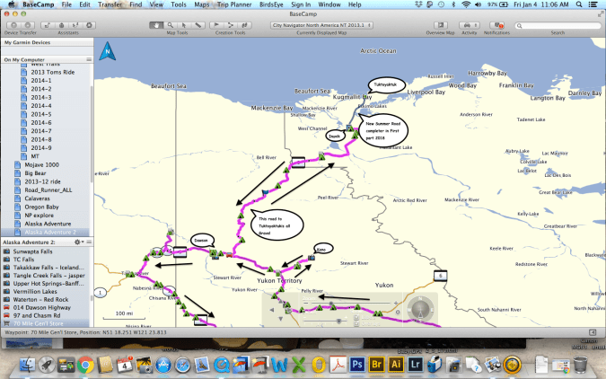
It was agreed that we should again reroute due to incoming harsh weather and the ferry strike going on The Marine Highway. The original route was to go across the ferry at Dawson City and follow the Top of the World Highway and the Taylor Highway to Tok, Alaska. Go south along the Alaska Highway along the Haines Highway to Haines, Alaska and take the ferry to Skagway. With the ferry strike it was decided to go south to Whitehorse, Yukon, Canada and directly to Skagway, Alaska via the South Klondike Highway.
Waking up early we drove into town and ate breakfast at Belinda’s Restaurant for some good ole pancakes and eggs.
After breakfast we parked along Front Street and walked to the ferry crossing of the Yukon River and crossed to walk to the Sternwheeler Graveyard located past the campground on the west side of the river. Tucked into the trees you will find the wooden remains of seven paddlewheelers. Once the primary mode of transportation in the region, these were abandoned when other transportation options became more popular.
Scuttled off the side of the river this graveyard hulking remains of wooden paddlewheel ships are broken and damage hulks that looks as though they were crashed onto shore. Most of the wrecks have collapsed but a few of the ships are still intact enough to explore, and many of the paddlewheels remain thanks to their metal skeletons.
After this interesting exploration of the ships it was time to walk back and head south toward Whitehorse. An interesting trip we are now doing in reverse from a few days ago on the way to The Dempster Highway.
Arriving back in Carmaks it was time to stop for gas and pickup a few things at the adjacent store. After shopping it was time for a quick lunch in the parking lot before continuing on to the destination for the night, Lake Leberge.
Lake Laberge is a widening of the Yukon River north of Whitrehorse. At 31 miles (50 k) long and from 1.25 to 3 miles (2 to 5 k) wide its water is always very cold, and its weather often harsh and variable. Its English name comes from 1870 commemorating the first French-Canadian to explore the Yukon in 1866, Michel LaBerge. During the late 19th and early 20th centuries winter sternwheelers carrying goods early in the shipping season on Lake Laberge regarded the lake as trouble, as it was one of the last areas of the river to thaw of ice.
Entering the campground it was signed as full but we continued around to see if there might be an empty campsite and to see the lake. Luckily a husband and wife were packing up to leave and asked if we wanted the campsite. We said thank you yes and waited 20 minutes as they packed up. What a wonderful camping spot, very close to the lake with a beautiful view from the site. Now for a nice dinner and to sit by the lakeshore and enjoy the scenery with peace and quiet.
View from the campsite
Sa far this trip has just been outstanding and I suspected it would continue on this way.
Close to 100,000 prospectors set off over the Chilkoot Trail in Dyea/Skagway, Alaska on foot then sailed up the Yukon River to find their wealth in the gold fields surrounding Dawson City, Yukon. With a population of only about 1,900 residents this National Historic Site and UNESCO nominated town has many restored buildings and sites to explore. A few of the places to explore and enjoy a trip back in time are a walking Tour of town, the Palace Grand Theater, the Jack London Museum, Diamond Tooth Gertie’s to join the Sourtoe Cocktail Club by having a shot with an actual toe in it at the Sourdough Saloon in the Downtown Hotel (the toe must touch your lips), see the SS Keno the last steamer to run the Yukon River, discover the areas history at the Dawson City Museum and just outside of town explore the grand old Dredge #4, Discovery Claim National Historic Site and the steamship graveyard.
First up for a bit of vehicle maintenance, the vehicles needed a complete cleaning with all the mud buildup from the drive yesterday. It took about 30 minutes each to get most of the dirt removed from the outside.
After the cleanup it was over to Dredge #4 to investigate. A guided tour is available to explore the inside of the dredge. An interesting informative tour is provided but it is not inexpensive, although I felt well worth the cost.
Dredge No. 4 mined gold from 1913 to 1959. This wooden-hulled bucketline sluce dredge is now located along Bonanza Creek Road about 8 miles (13 k) south of Dawson City along Upper Bonanza Creek road. This the largest wooden-hulled dredge in North America was designated a National Historic Site on 22 September 1997.
Designed by the Marion Steam Shovel Company it was hauled in pieces to Dawson City at a cost of $134,800 for shipping which was then built by the Canadian Klondike Mining Company on site at Claim 112 near Ogilvie Bridge, the current location of the bridge over the river along the Klondike Highway to Dawson City. It moved to its current location along Bonanza Creek by digging a path and filling in the area behind itself in its own pond.
Excavating gravel at 22 buckets per minute with 72 large buckets that processed 18,000 cubic yards (14,000 m3) of material per day. In use from late April or early May until late November each year, and sometimes throughout winter, it captured nine tons of gold during its operation.
Continuing along the dirt road we made a stop at the Discovery Claim National Historic Site where gold was first discovered in the area for a short walk around the displays explaining the mining operations of the area.
Stopping by a small tourist stop with a souvenir shop, old buildings and quite a lot of old mining equipment I explored the old buildings and equipment having a fun time with my camera.
Back in town I dropped the car off at the hotel and wandered the rest of the afternoon and evening around the streets, shops and museums of Dawson City. First up was the Dawson City Visitors Center to look around the exhibits and get an idea for a much needed very late lunch. Leaving there with several ideas I strolled across the street to the NWT Dempster Highway Visitor Center to see what was missed during the previous few days. This would be a good stop if you are going up the Highway after your visit here in Dawson City.
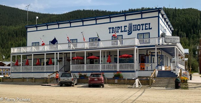
After talking to the very nice informative person working there I continue my wandering to the Triple J Hotel and restaurant for my late lunch. I had the tasty Wild Salmon Burger with a caper aioli and an iced tea. Sitting on the outside porch I enjoyed my meal watching the activity happening on the street it was a very good relaxing meal.
I sat on the porch on the left for lunch. What a wonderful place to have lunch.
After lunch I continue on to the Dawson City Museum where I explore the exhibits on 2 floors of the old Territorial Administration Building discovering the natural history of the Klondike Gold Fields through exhibits, displays, dioramas and informative shows. You explore the history of Yukon’s First Peoples and early explorers. Experience the Gold Rush through the stampeders and entrepreneurs, and the visionaries. I was fortunate enough to see a live demonstration of a sluce shaker box in action and how gold was recovered from the river and stream beds.
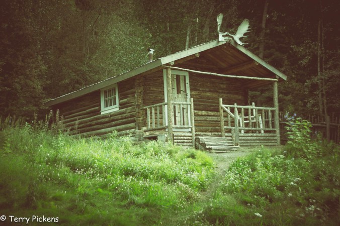
Walking to the outskirts of town I visit the Robert Service Cabin. Service was a British born poet referred to as the “the Bard of the Yukon”. He was one of the most successful poets of the Twentieth Century. who arrived in the Yukon as a bank clerk turning vivid tales, told to him by veterans of the great gold rush, into classic poems. Robert Service arrived in Dawson City in 1908 continuing to write about his northern adventures until his departure from Dawson, and the Yukon, in 1912. Sadly the cabin was closed for the day so I couldn’t get a glimpse inside to see how this gentleman lived.
Just down the street was Jack London Museum and Cabin. This museum and cabin shows the time Jack London spent a year in the Klondike. Trying his hand at mining he still spent most of his time writing stories that would make him a well known author. It again was closed due to the late time I had passed there.
Just west is a pedestrian-bicycle trail along the Klondike and Yukon rivers that I followed back to my tent cabin for the evening. Stopping at the store for a few items I continue to the cabin to shower, due some laundry and relax for the evening. Another travel day in the morning so must rest up.
It was amazing that just before the grocery store I noticed a large European based adventure RV turning into a parking lot. I had to get a closer look and hopefully talk to its drivers. I met a wonderful couple, he from Luxembourg, a small European country surrounded by Belgium, France and Germany and his wife from France. I talked with them for about an hour listening to their adventure so far and where they are going on their long trip.
As a side note, they stopped by my house when I returned from the adventure for dinner and the stayed the night on their trek to Mexico and Central America. I wish them well on their journey.
Returning south along the Dempster it is decided to continue all the way from Inuvik to Dawson City in one day. The weather has turned bad this day and under a constant sometimes heavy rain it was decided to push on.
Reaching Eagle Plains for the required fuel stop we head over to the small restaurant to pick up a quick bite to eat. A group of travelers from Australia are enjoying their meal and we talk to the for about a half hour before leaving them as they head north.
The closer we got to the Klondike Hwy the weather was changing for the better. We continued on as it was not that far to Dawson City at that point.
Upon reaching the Klondike Hwy, Canada 2, it is time to head west for Dawson City, Yukon Territories.
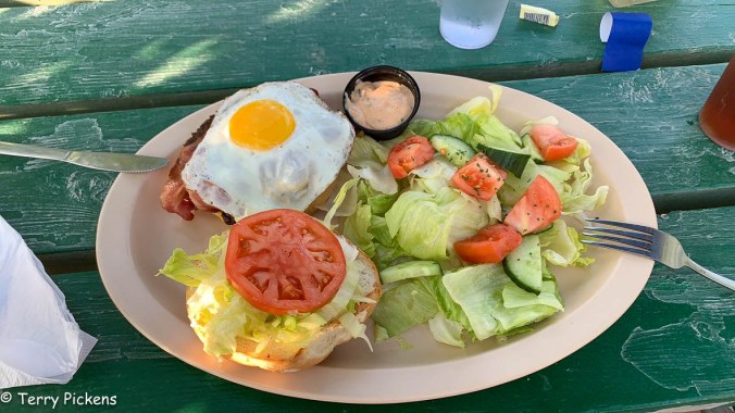
It was 7:30 by the time we arrived in Dawson City and being very hungry, stopped at Sourdough Joe’s for a bite to eat. I had a burger with bacon, cheese, chili, an egg and a small salad. DELICIOUS.
Sourdough Joes Burger
We start the search for a place to spend 2 nights here and decide to splurge on a room. All the places we checked were fully booked but luckily one manager called around to other locations for available rooms. It was discovered an establishment named The White House had 2 tent cabins available for the 2 nights we planned on staying. Driving the short 1/2 mile there we look at the rooms and decide this is the perfect place to wind down after the adventure north we just had. Renting the 2 tent cabins with mine having a queen bed, a single bed, lounge sofa, small dining table and kitchen utensils for heating water for tea/coffee.. This was no ordinary canvas tent accommodation, it was provided with a wooden floor and door, covered porch and a hard translucent roof covering, shared bathroom and shower and a small outdoor kitchen/dining area to prepare food, this was a perfect place to enjoy 2 nights of glamping comfort.
White House Tent Cabin
White House Tent Cabin Interior
White House Tent Cabin Interior
White House Tent Cabin View from Porch
White House Tent Cabin Restroom and Shower area
White House Tent Cabin Kitchen area
White House Tent Cabin View to Picnic Table and Rooms.
Named the Inuvik-Tuktoyaktuk Highway (ITH) the road begins at the end of the Dempster Highwayin Inuvik, Northwest Territories and continues for 138 kilometres (86 mi) north towards Tuktoyaktuk, a coastal community on the Arctic Ocean. With its eight bridges this two-lane gravel road was opened on April 29, 2017. The Inuvik to Tuktoyaktuk ice road closed for the last time and now all vehicle traffic is via the new all-weather road.
The idea of an all-season highway from Inuvik to Tuktoyaktuk was first brought up in the 1960s. In 1974 the Public Works of Canada completed a survey and technical study of a 140 km (87 mi) route between the towns. The local First Nations people completed their environmental review of the highway in January 2013 and granted their approval. In March 2013 the territorial legislature approved funds for construction of the all-weather highway.
Construction began in January 2014, and was completed with one crew working from Inuvik and a second working from Tuktoyaktuk. The highway opened on November 15, 2017 and includes eight bridges and 359 culverts.
Tuktoyaktuk is a hamlet of about 898 people settled in 1928. This natural harbor has been used for centuries by the Inuvialuit as a place to harvest caribou and beluga whales. There are not many tourist facilities in Tuktoyaktuk, a few rooms, a small camping area, grocery store, gas station, visitor center, and food establishments. There are numerous individuals giving tours and lectures on the local culture and landscape. Still finding it’s own with the new influx of visitors due to the new all season highway it is a remote outpost that is a destination you should not miss.
Such a magnificent Highway. The views are stunning that go on forever.
This slideshow requires JavaScript.
Video by H. Berge
Entering the town of Tuktoyaktuk it was such a small hamlet.
Finally I dip my feet into the Arctic Ocean, the furthest point north I have been in my life. A life long goal of mine has been to dip my feet into the Arctic Ocean. A goal finally achieved.
An example of the native building is available for viewing and has scheduled tours available from the visitor center. There are 2 structures at the site, one a house without its finish showing how it was constructed and the other a finished structure. To get into the finished structure you must take a scheduled tour.
Tuktoyaktuk is a special place for it has one of the highest concentrations of pingos, with some 1,350 examples.
What is a Pingo? it is a mound of earth covered ice located only in Arctic regions formed by hydrostatic pressure in a permafrost environment.
After eating a great lunch at Grandma’s Kitchen we started our way back to Inuvik and our campsite for the night.
Not in a hurry to leave as it was only a 3 1/2 hour drive to our next destination, Inuvik, it was time for a nice breakfast and to visit with 2 other travelers on the road north. Leaving about 10:30 we passed through Fort McPherson again and marveled at the natural beauty surrounding this road.
In a short 41 miles (66 k) you arrive at the ferry crossing of the Mackenzie River (Tsiigehnjik,. a river named a Canadian Heritage River in 1993. This ferry actually has 3 stops on its sailing, the southern route of the Dempster, northern route of the Dempster and the small town of Tsiigehnjik. This town has no roads built to it due to the river and permafrost conditions of the area.
By Heather Berge
Stopping 23 miles before Inuvik we visit Titheqehchii Vitail Lookout trail head for a short 10 minute walk to a beautiful over look of Cambell Lake.
Arriving in the town of Inuvik (The Place of Man) the entire town is constructed on permafrost. Population is at 3,243 as of 2016 this small planned village has unique utildor corridors carry all the water, sewage and heating systems between the buildings. This is also the first Canadian town built north of the Arctic Circle that provides normal city services to its residents. Inuvik has 2 gas stations, repair shops, lodgings, campgrounds, restaurants, fast food, groceries, and clothing stores. This was the farthest north a year round road reached until the current road to Tuktoyaktuk was built and opened last year, all access to Tuktoyaktuk was by plane or the Winter Road.
Setting up camping at Happy Valley Territorial Park right in town was within walking distance was a wonderful place to eat, the grocery store and the Visitor Center. The campground has toilets, showers (free) and laundry facilities (at an extra cost) available. The tent platforms were welcomed.
Walking across the street it was time for a late lunch, early dinner at Alestine’s, a converted bus that filled the tummy.
Continuing the walk it was to the grocery store to see what was available, this store is not just a grocery store but an outdoor equipment shop as well. Then off for the visitor center across town, we were disappointed to learn it was closed for a couple of hours for lunch. Heading back to the grocery store to pick a few items up it was back to camp for laundry, showers and relaxing before our day trip tomorrow to Tuktoyaktuk and the Arctic Ocean, 86 miles (138 k) north along Highway 10 The Inuvik-Tuk Highway (ITH).
From the junction of the Klondike and Dempster Highways, it’s 456 miles (734 km) to Inuvik, North West Territories and then an additional 86 miles (138 km) north to Tuktoyaktuk, North West Territories beside the Arctic Ocean.
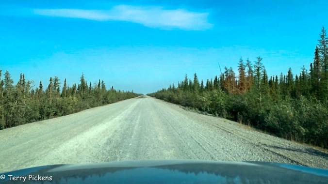
The Dempster Highway is only paved for the first 5 miles (8 km) from the Klondike Highway and the last 6 miles (10 km) into Inuvik. The road is open year round but it is a hard road on vehicles and tires, its gravel surface has sudden changes, potholes, becomes boggy and slick in wet weather and is made of crushed shale, which is very damaging to tires. You will need to use 2 free ferries on your drive to Inuvik. Calcium Chloride is used to stabilize the road during wet conditions so it’s advisable to clean the vehicle as soon as you can after traversing this road.
Woke up the next morning and there was a light rain falling. It lasted for a few hours in the morning then cleared up.
Making our way up the Dempster we pass Engineer Creek Yukon Government Campground at mile 120 (193.8 k) where it was decided a short break was needed. We drive around the loop of campsites to explore the possibility of this being a stop on the way south. It was fortunate that we went through as I noticed a gentleman’s vehicle I knew from Instagram that was also making the trip north. He had already been to Tuktoyaktuk and was making his way south. Stopped for about 30 minutes exchanging tales of our adventures so far. The campground is full and very quiet although quite soggy from the rain and has many mosquitoes swarming about, no doubt from the rain. This was an area with he most mosquitoes experienced on the trip.
You must go all the way to Eagle Plains for gas, food, and lodging. This small outpost is located 229 miles (369 k) form the the gas station at the intersection with the Klondike Highway. Remember to fill up with gas when available along the Dempster, there might be long distances between services.
At 252 miles (405.5 km) from the Junction with the Klondike Highway you arrive at the Arctic Circle.
At 289 miles (465 km) you pass into the Northwest Territories. This Territory has approximately 519,734 sq mi (1,346,106 km2 ) with a population of only 44,420 residents (estimate for 2019).
Just a short distance takes you to the first ferry crossing at the Peel River. We are the only vehicles on this northern crossing of the ferry.
Video by H. Berge
Video by H. Berge
One mile past the ferry crossing we arrive at our camp for the night, Nitainlai Interpretive Center and Territorial Park Campground. The center has very nice exhibits and displays of the Gwich’in culture. The adjacent campground has water, firewood, toilets and wonderful warm showers. It is a nice respite after a days driving.
Before settling down for the evening gasoline is required in the vehicles and as tomorrow is Sunday the stations won’t be open till about noon. It is a short drive north into Fort McPherson, a town of a population of approximately 791 people with a Café, 2 grocery stores, 2 gas/diesel stations and an 8-room hotel 342 miles (465 k) along the highway.
After an easy breakfast we left camp about 8:30 to continue along Canada Highway 4, The Campbell Highway following old fur trade routes. This 362-mile (5983 km) paved but mostly gravel road will lead to Highway 2, the Klondike Highway, for the adventure to the far reaches of the Northwest Territories and the Arctic Ocean along the Dempster Highway.
Photo by H. Berge
Photo by H. Berge
Photo by H. Berge
The highway is named after the first white man to explore the Yukon area, John Campbell, this all season road leads from Watson Lake to just north of Carmacks on Klondike Highway (2). This rougher road is shorter in distance than continuing along to the junction of the Alaskan Highway and the Klondike Highway but it is much slower. Services are few and far between along this highway.
Stopping at several overlooks of the Yukon River we noticed several small dots moving along the river. Canoeists were floating and paddling with the current, their boats loaded down with camping gear. Now that looks like a great adventure to make (another bucket list item).
We are now in a landmass named Beringia stretching from eastern Siberia, through Alaska, and to the Yukon. This area was not covered in glaciers at the time of the Ice Age but was an area of dry, dusty, treeless Steppe where you could see Bison, wild ponies, Wooly Mammoths among other animals. During the ice age the water level dropped 425 feet (130 m) creating Beringia, the land bridge between Russia and North America.
Making it to the the Klondike Highway I stopped at a scenic overlook and made lunch. What a delightful place to eat.
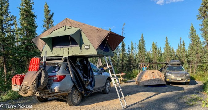
It was decided early that this day would be another drive day to make it to the Dempster Highway quickly as a storm was moving into the area. Wanting good weather in Tuktoyaktuk we pressed on making it to the start of the Dempster at about 4:30 in the afternoon. Filling with gas at the intersection we continued about 70 miles to stop and camp at the end of a emergency airstrip. Pulling far off the end of the runway and completely off the marked airstrip we set up camp at 7:00.
9:08 in the evening
10:18 in the evening, no darkness tonight. sun sets for only about a couple of hours. Twilight all night long. Photo by H. Berge
Leaving the Northern Rockies Lodge we continuing traveling on the Alaska Highway heading toward the Yukon Territory.
Lower Liard Bridge built in 1943 is a 1,143-foot (348 m) long suspension bridge is the last remaining suspension bridge along the Highway.
Liard River Hot Springs Provincial Park is a day use area with some camping. A short hike leads back into the Hot Springs Pool and has been a favorite stop along the highway to soak away those long days of driving. Passing through Liard River Hot Springs there are buffalo all over the road. It was like I was transported to Yellowstone National Park where I was stuck in a Buffalo traffic jamb. The buffalo here stuck to the shoulder of the road not creating a problem for traffic.
The Alaska Highway travels east and west for a portion of the route today so you pass into and back out of the Yukon Territory for a few miles until you enter it for good about the 7.5 miles (12 k) before the town of Watson Lake.
Next stop was Watson Lake, a town 612 miles (980 km) along the Alaska Highway is best known for the few acres of the offbeat at the Sign Post Forest. Designated in 2013 as a Yukon Historic Site, was started by Carl Lindley by adding a sign at this location pointing to his hometown with the mileage. Other G.I.’s added more signs to the post for their hometowns. started this collection of signs and license plates from all over the world during the construction of the AL-CAN. Numbering about over 80,000 signs travelers are still adding to this collection. Right behind is the Alaska Highway Interpretive Center, which has a video on Yukon history with photos and displays of the construction of the AL-CAN. This was town was important during the construction due to the airport and being one of the major refueling stops of the Northwest Staging Route.
Turning north along Canada Highway 4, The Campbell Highway, a 362-mile (5983 km) paved but mostly gravel road will lead to Highway 2.
Named after the first white man to explore the Yukon area, John Campbell, this all season road leads from Watson Lake to just north of Carmacks on Klondike Highway (2). This rougher road is shorter in mileage than continuing along to the junction of the Alaskan Highway and the Klondike Highway but it is much slower. Services are few and far between along this highway.
At Ross River, a supply and communications base for prospectors in the area that is now a jumping off point for hunters and canoeists, it was decided to stopper the evening at Lapie River Campground. Setting ups camp we took the short walk down too the river to enjoy the sounds.
It was a short drive to Dawson Creek, B.C. from the campsite.
Along this section of Highway 97 is the Town of Chetwynd with its chainsaw carving project that began as part of the 50th anniversary of the construction of the Alaska (Alcan) highway. Located along the main roadway and at the Visitor Center these carved chainsaw statues are something to admire and are exquisite as you pass through.
The Alaskan Highway formally starts in Dawson Creek, BC at Mile Marker 0. The 1,422-mile (2,288.5 km) long formal Alaskan Highway ends in Delta Junction, AK while the unofficial end is in Fairbanks, AK, 1,523 miles (2,451 km) from Dawson Creek, BC.
Dawson Creek was incorporated as a city in 1958 and is a principal railhead of the British Columbia Railway and the intersection of 4 major highways in the area. Make sure to get your photo at Milepost 0 Cairn, visit the Pioneer Village, Dawson Creek Art Gallery and the Alaska Highway House to name a few of the sites in town. And if you have time visit the Northern Alberta Railways Park.
We saw the Mile Zero Cairn / Sign Post for a photo op, the Surveyor Statue, visited the Alaska Highway House Museum, walked the couple of blocks to see the Official Zero-mile Post a few blocks away and had a nice lunch at Hug a Mug’s Coffee House and Eatery.
It is sad the original, official mile post mark was a part of countless pranks and kidnappings with this new one replacing it in the 1980’s.
Driving 20 minutes north of town, the stop for the night was at the Kiskatinaw Provincial Park. This campsite is located right next to the curved, wooden Historic Kiskatinaw Bridge. Kiskatinaw means “cutback” in Cree. Constructed in 1942-43 by the US Public Roads Administration it replaced an original 3 span timber trestle. With a 9 degree curve to accommodate the Steep grade change and the need to notch a cliff at the east end. It was one of 133 permanent bridges built to replace the temporary bridges built by the U.S Army. At about 122m (400 foot) long it was the first curved bridge to be constructed in Canada and one of the last in North America to remain.


You must be logged in to post a comment.