Day 9 – The final push north to Tuktoyaktuk, Northwest Territories and the Arctic Ocean.

Named the Inuvik-Tuktoyaktuk Highway (ITH) the road begins at the end of the Dempster Highway in Inuvik, Northwest Territories and continues for 138 kilometres (86 mi) north towards Tuktoyaktuk, a coastal community on the Arctic Ocean. With its eight bridges this two-lane gravel road was opened on April 29, 2017. The Inuvik to Tuktoyaktuk ice road closed for the last time and now all vehicle traffic is via the new all-weather road.

Map 4

The idea of an all-season highway from Inuvik to Tuktoyaktuk was first brought up in the 1960s. In 1974 the Public Works of Canada completed a survey and technical study of a 140 km (87 mi) route between the towns. The local First Nations people completed their environmental review of the highway in January 2013 and granted their approval. In March 2013 the territorial legislature approved funds for construction of the all-weather highway.

Construction began in January 2014, and was completed with one crew working from Inuvik and a second working from Tuktoyaktuk.  The highway opened on November 15, 2017 and includes eight bridges and 359 culverts.

Tuktoyaktuk-A

Tuktoyaktuk is a hamlet of about 898 people settled in 1928. This natural harbor has been used for centuries by the Inuvialuit as a place to harvest caribou and beluga whales. There are not many tourist facilities in Tuktoyaktuk, a few rooms, a small camping area, grocery store, gas station, visitor center, and food establishments. There are numerous individuals giving tours and lectures on the local culture and landscape. Still finding it’s own with the new influx of visitors due to the new all season highway it is a remote outpost that is a destination you should not miss.

Such a magnificent Highway. The views are stunning that go on forever.

This slideshow requires JavaScript.

Video by H. Berge

Entering the town of Tuktoyaktuk it was such a small hamlet.

Finally I dip my feet into the Arctic Ocean, the furthest point north I have been in my life. A life long goal of mine has been to dip my feet into the Arctic Ocean. A goal finally achieved.

An example of the native building is available for viewing and has scheduled tours available from the visitor center. There are 2 structures at the site, one a house without its finish showing how it was constructed and the other a finished structure. To get into the finished structure you must take a scheduled tour.

Tuktoyaktuk is a special place for it has one of the highest concentrations of pingos, with some 1,350 examples.

What is a Pingo? it is a mound of earth covered ice located only in Arctic regions formed by hydrostatic pressure in a permafrost environment.

After eating a great lunch at Grandma’s Kitchen we started our way back to Inuvik and our campsite for the night.


Day 8 – A short drive to Inuvik, Northwest Territories, Canada

Not in a hurry to leave as it was only a 3 1/2 hour drive to our next destination, Inuvik, it was time for a nice breakfast and to visit with 2 other travelers on the road north. Leaving about 10:30 we passed through Fort McPherson again and marveled at the natural beauty surrounding this road.

In a short 41 miles (66 k) you arrive at the ferry crossing of the Mackenzie River (Tsiigehnjik,. a river named a Canadian Heritage River in 1993. This ferry actually has 3 stops on its sailing, the southern route of the Dempster, northern route of the Dempster and the small town of Tsiigehnjik. This town has no roads built to it due to the river and permafrost conditions of the area.

Stopping 23 miles before Inuvik we visit Titheqehchii Vitail Lookout trail head for a short 10 minute walk to a beautiful over look of Cambell Lake.

7-28-18

Arriving in the town of Inuvik (The Place of Man) the entire town is constructed on permafrost. Population is at 3,243 as of 2016 this small planned village has unique utildor corridors carry all the water, sewage and heating systems between the buildings. This is also the first Canadian town built north of the Arctic Circle that provides normal city services to its residents. Inuvik has 2 gas stations, repair shops, lodgings, campgrounds, restaurants, fast food, groceries, and clothing stores. This was the farthest north a year round road reached until the current road to Tuktoyaktuk was built and opened last year, all access to Tuktoyaktuk was by plane or the Winter Road.

Setting up camping at Happy Valley Territorial Park right in town was within walking distance was a wonderful place to eat, the grocery store and the Visitor Center. The campground has toilets, showers (free) and laundry facilities (at an extra cost) available. The tent platforms were welcomed.

Walking across the street it was time for a late lunch, early dinner at Alestine’s, a converted bus that filled the tummy.

Continuing the walk it was to the grocery store to see what was available, this store is not just a grocery store but an outdoor equipment shop as well. Then off for the visitor center across town, we were disappointed to learn it was closed for a couple of hours for lunch. Heading back to the grocery store to pick a few items up it was back to camp for laundry, showers and relaxing before our day trip tomorrow to Tuktoyaktuk and the Arctic Ocean, 86 miles (138 k) north along Highway 10 The Inuvik-Tuk Highway (ITH).

Day 7 – Up the Dempster to the Arctic Ocean and Tuktoyaktuk

From the junction of the Klondike and Dempster Highways, it’s 456 miles (734 km) to Inuvik, North West Territories and then an additional 86 miles (138 km) north to Tuktoyaktuk, North West Territories beside the Arctic Ocean.

The Dempster Highway is only paved for the first 5 miles (8 km) from the Klondike Highway and the last 6 miles (10 km) into Inuvik. The road is open year round but it is a hard road on vehicles and tires, its gravel surface has sudden changes, potholes, becomes boggy and slick in wet weather and is made of crushed shale, which is very damaging to tires. You will need to use 2 free ferries on your drive to Inuvik. Calcium Chloride is used to stabilize the road during wet conditions so it’s advisable to clean the vehicle as soon as you can after traversing this road.

Woke up the next morning and there was a light rain falling. It lasted for a few hours in the morning then cleared up.

Making our way up the Dempster we pass Engineer Creek Yukon Government Campground at mile 120 (193.8 k) where it was decided a short break was needed. We drive around the loop of campsites to explore the possibility of this being a stop on the way south. It was fortunate that we went through as I noticed a gentleman’s vehicle I knew from Instagram that was also making the trip north. He had already been to Tuktoyaktuk and was making his way south. Stopped for about 30 minutes exchanging tales of our adventures so far. The campground is full and very quiet although quite soggy from the rain and has many mosquitoes swarming about, no doubt from the rain. This was an area with he most mosquitoes experienced on the trip.

You must go all the way to Eagle Plains for gas, food, and lodging. This small outpost is located 229 miles (369 k) form the the gas station at the intersection with the Klondike Highway. Remember to fill up with gas when available along the Dempster, there might be long distances between services.

At 252 miles (405.5 km) from the Junction with the Klondike Highway you arrive at the Arctic Circle.

At 289 miles (465 km) you pass into the Northwest Territories. This Territory has approximately 519,734 sq mi (1,346,106 km2 ) with a population of only 44,420 residents (estimate for 2019).

Just a short distance takes you to the first ferry crossing at the Peel River. We are the only vehicles on this northern crossing of the ferry.

Video by H. Berge

Video by H. Berge

One mile past the ferry crossing we arrive at our camp for the night, Nitainlai Interpretive Center and Territorial Park Campground. The center has very nice exhibits and displays of the Gwich’in culture. The adjacent campground has water, firewood, toilets and wonderful warm showers. It is a nice respite after a days driving.

7-27-25

Before settling down for the evening gasoline is required in the vehicles and as tomorrow is Sunday the stations won’t be open till about noon. It is a short drive north into Fort McPherson, a town of a population of approximately 791 people with a Café, 2 grocery stores, 2 gas/diesel stations and an 8-room hotel 342 miles (465 k) along the highway.


Day 5 – Into the Yukon Territories

Leaving the Northern Rockies Lodge we continuing traveling on the Alaska Highway heading toward the Yukon Territory.


Lower Liard Bridge built in 1943 is a 1,143-foot (348 m) long suspension bridge is the last remaining suspension bridge along the Highway.

Liard River Hot Springs Provincial Park is a day use area with some camping. A short hike leads back into the Hot Springs Pool and has been a favorite stop along the highway to soak away those long days of driving. Passing through Liard River Hot Springs there are buffalo all over the road. It was like I was transported to Yellowstone National Park where I was stuck in a Buffalo traffic jamb. The buffalo here stuck to the shoulder of the road not creating a problem for traffic.


The Alaska Highway travels east and west for a portion of the route today so you pass into and back out of the Yukon Territory for a few miles until you enter it for good about the 7.5 miles (12 k) before the town of Watson Lake.


Next stop was Watson Lake, a town 612 miles (980 km) along the Alaska Highway is best known for the few acres of the offbeat at the Sign Post Forest. Designated in 2013 as a Yukon Historic Site, was started by Carl Lindley by adding a sign at this location pointing to his hometown with the mileage. Other G.I.’s added more signs to the post for their hometowns. started this collection of signs and license plates from all over the world during the construction of the AL-CAN. Numbering about over 80,000 signs travelers are still adding to this collection. Right behind is the Alaska Highway Interpretive Center, which has a video on Yukon history with photos and displays of the construction of the AL-CAN. This was town was important during the construction due to the airport and being one of the major refueling stops of the Northwest Staging Route.


Turning north along Canada Highway 4, The Campbell Highway, a 362-mile (5983 km) paved but mostly gravel road will lead to Highway 2.


Named after the first white man to explore the Yukon area, John Campbell, this all season road leads from Watson Lake to just north of Carmacks on Klondike Highway (2). This rougher road is shorter in mileage than continuing along to the junction of the Alaskan Highway and the Klondike Highway but it is much slower. Services are few and far between along this highway.

At Ross River, a supply and communications base for prospectors in the area that is now a jumping off point for hunters and canoeists, it was decided to stopper the evening at Lapie River Campground. Setting ups camp we took the short walk down too the river to enjoy the sounds.


Day 3 – To Dawson Creek

It was a short drive to Dawson Creek, B.C. from the campsite.

Along this section of Highway 97 is the Town of Chetwynd with its chainsaw carving project that began as part of the 50th anniversary of the construction of the Alaska (Alcan) highway. Located along the main roadway and at the Visitor Center these carved chainsaw statues are something to admire and are exquisite as you pass through.

Chetwynd_from Google

The Alaskan Highway formally starts in Dawson Creek, BC at Mile Marker 0. The 1,422-mile (2,288.5 km) long formal Alaskan Highway ends in Delta Junction, AK while the unofficial end is in Fairbanks, AK, 1,523 miles (2,451 km) from Dawson Creek, BC.

Alaska-Highway-Map

Dawson Creek was incorporated as a city in 1958 and is a principal railhead of the British Columbia Railway and the intersection of 4 major highways in the area. Make sure to get your photo at Milepost 0 Cairn, visit the Pioneer Village, Dawson Creek Art Gallery and the Alaska Highway House to name a few of the sites in town. And if you have time visit the Northern Alberta Railways Park.

We saw the Mile Zero Cairn / Sign Post for a photo op, the Surveyor Statue, visited the Alaska Highway House Museum, walked the couple of blocks to see the Official Zero-mile Post a few blocks away and had a nice lunch at Hug a Mug’s Coffee House and Eatery.

It is sad the original, official mile post mark was a part of countless pranks and kidnappings with this new one replacing it in the 1980’s.

ACX-ACP90184 - © - Ron Erwin

Driving 20 minutes north of town, the stop for the night was at the Kiskatinaw Provincial Park. This campsite is located right next to the curved, wooden Historic Kiskatinaw Bridge. Kiskatinaw means “cutback” in Cree. Constructed in 1942-43 by the US Public Roads Administration it replaced an original 3 span timber trestle. With a 9 degree curve to accommodate the Steep grade change and the need to notch a cliff at the east end. It was one of 133 permanent bridges built to replace the temporary bridges built by the U.S Army. At about 122m (400 foot) long it was the first curved bridge to be constructed in Canada and one of the last in North America to remain.


Day 2 – Onward toward Dawson Creek and the Alaskan Highway

After waking up and eating a good breakfast we continue north on Canada Hwy 97 and take a side loop road to Chasm Ecological Reserve. This canyon was carved by a stream 10,000 years ago at the close of the Ice Age. You can see the layers of lava in the walls of the chasm.

Along this section of Highway there are Mile Houses. These were so named because they are located that many miles from Lillooet (Mile 0) of the Cariboo Wagon Road. As the gold rush subsided, ranchers began to settle the surrounding areas and the towns held onto those names.

At the town of 100 Mile House, the worlds largest pair of cross country skis, as stated by the plaque in front, stand in front of the Visitors Center. 100 Mile House’s origins as a settlement go back to when Thomas Miller owned a collection of buildings serving as a resting point for the traffic of gold seekers moving north to the gold fields.  It acquired its name during the Cariboo Gold Rush when a roadhouse was constructed in 1862 at the 100 mile (160 km) mark up the Cariboo Wagon Road from Lillooet.

Giant Skis

And the first revision to the trip, it was decided to not stop at Barkerville and continue north. Barkerville shall be saved for a future adventure.

After passing through the large town of Prince George it was time to visit another site just off the highway, The Huble Homestead Historical Park.

Getting there right before to closing we had about a 1/2 hour to hurriedly walk through the Farmhouse, and Barn before looking around at the farm equipment in the fields surrounding the homestead. The farmhouse is a typical Ontario Farmhouse that took nearly a year to complete. Mr Huble later relocated and connected the old smaller family cabin to the side of the house to be used as summer kitchen. The house consists of a parlor, dining room, an office, a first floor master bedroom, and four upstairs bedrooms.

A barn, equipment shed and several small individual workers cabins surround the homestead.

Al Huble and Edward Seebach partnered to set up a business selling goods to trappers in the area and people passing through. After 10 years the business became so successful they built a false front General Store facing the river, painting it white to draw attention to it. This building, relocated closer to the Homestead Historical Park, served local land owners, travelers on the Fraser River and construction crews for the new Grand Trunk Pacific Railroad.

Homestead 12

Continuing the northward trek, the nights campsite was at Crooked River Provincial Park along side Bear Lake. After setting up camp and having a quick bite to eat it was time for a stroll down along the lake shore to again be witness to a beautiful sunset.

The Northern Adventure – Journey to the Yukon

Having already started the first post of this adventure HERE although I should explain what this Journey is about and where in shall go. 

But First:

ADVENTURE – An exciting, daring, bold, risky or very unusual experience or undertaking fraught with physical, financial or psychological risks.

Lets go on an Adventure

What does this mean? It can be different for everyone; skydiving, mountain climbing, scuba diving, river rafting, caving (spelunking) traveling, exploring…… anything that is outside the ordinary for that individual is an adventure. Many make their adventures a way of life and never stop. For some it is just a day, weekend or short trip. Does it need to involve speed, height, a high level of physical exertion or highly specialized gear, some would say yes. I do not think that at all, it is up to the individual the extent of the adventure to be accomplished.

The Individuals:

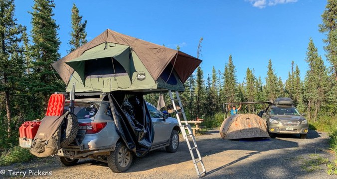
The explores will consist of 2 individuals who are basically strangers, we came together on social media in our interests for the outside and vehicle exploration. Communicating through the computer is all we done as we live in different states. The team consists of Heather’s 2015 Subaru Outback (#heidi_roo), and myself in a 2017 Subaru Outback (#sled_rider).


The Journey:

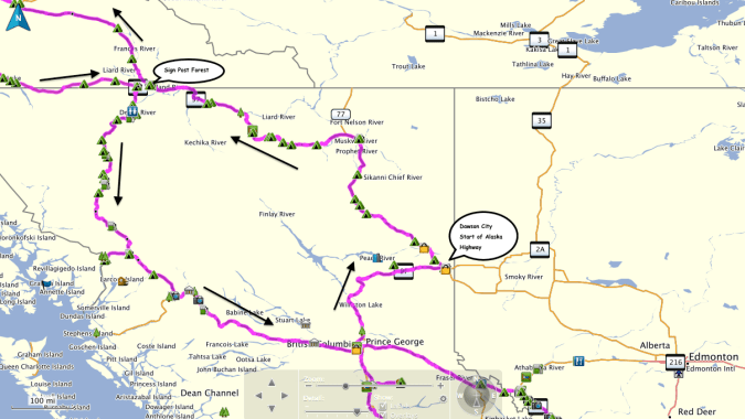
It will involve a drive from Vancouver, WA to Dawson City, Yukon Territories, Canada, up the Dawson highway to the Arctic Ocean at Tuktoyaktuk, YT, Canada and back. It is something I have never done and it has always been on my bucket list. I have taken 2 cruises to Alaska and have loved the experiences. I now want to experience the lands of Canada and Alaska from the ground driving through the countryside.

Map 1Map 2Map 3Map 4

  • Will it be an adventure? …..yes as this will go far north as you can drive in Canada.
  • Will it be exhilarating? …..Yes.
  • Will it be fun and exciting? …..Definitely.
  • Is this outside the box for travels…..Definitely.
  • Am I excited to plan and start this adventure? …..OH YES.
  • Has this route been carved in stone…..NO, it will change even as we travel I’m sure.

The trip will leave Vancouver, WA and head up Interstate 5 to the Canadian Border. Crossing into British Columbia, Canada the journey continues north to Prince George, BC and to the start of the Alaskan Highway in Dawson Creek, B.C., Canada. British Columbia has a population of approximately 4,751, 600 in 364,764 sq. miles (944,735 sq. km) making it the 3rd largest province in Canada.

Heading north from Dawson Creek we will go along The Alaskan Highway, Canada Highway 97, passing through Fort Nelson and entering the Yukon Territories, Canada just before Watson Lake to visit the Sign Forest. The Yukon has the smallest population of any Province/Territory of Canada at approximately 37,858 with a land area of 186,661 sq. miles (483,450 sq. km).

What is the difference between a Province and Territory? Territories are administrated differently than Provinces. Provincial government powers are laid out in the Constitution, whereas the territories are given powers from the federal government, thus the territories control less of their own affairs.

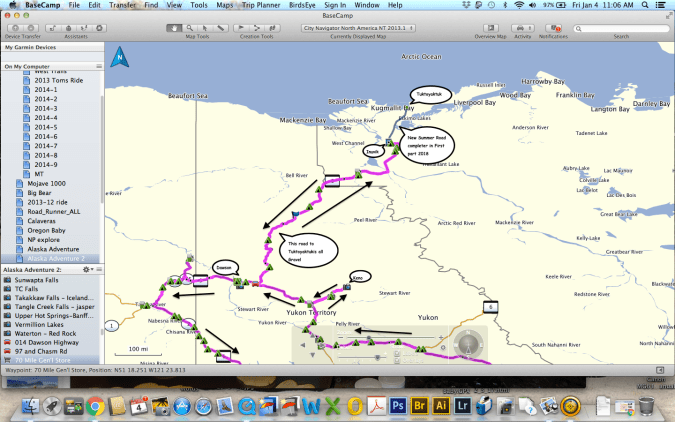
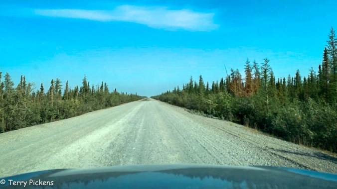
Heading north on The Campbell Highway, Canada 4 we will stop in the old mining town of Mayo / Keno then will then make our way up the Dempster Highway, Canada 5, crossing the Arctic Circle, Inuvik, Northwest Territories, Canada and then continue the final 130 km on the new all season road to Tuktoyaktuk, Northwest Territories, Canada and the Arctic Ocean. The Northwest Territories has an approximate population of 44,469 that live in an area of 452,480 sq. miles (1,171,918 sq. km), this province has about the one sixth of the land area of Canada making it the second largest and most populous territory of Canada.

I mention the population and sizes of these Territories as they are still sparsely populated; a majority of Canadians live very close to the border with the United States. The population for the state of California is estimated to be 39,497,000 in 2017 with an area of 163,696 sq. miles (423,970 sq. km). The state of Washington has approximately a population of 7,535,591 and a land area of 71,362 sq. mi (184,827 sq. km). When you look at these numbers California has 241 people per sq. mile (93 people per sq. km), Washington has 106 people per sq. mile (40 people per sq. km), while The Yukon with 6.5 people per sq. mile (1 per sq. km) and The Northwest Territories having 1 person per sq. mile (about 1 person per 2 sq. km). So as you can see the farther north we head the less people, cities and urbanization will be encounter.

SOUNDS LIKE A GOOD PLAN.

After dipping our feet into the Arctic Ocean and exploring the area it will be time to return to Dawson City, Yukon Territories, Canada to explore the old mining district and town. The journey will then cross the Yukon River on a ferry as we head west to Chicken, Alaska along Top of the World Highway. Continuing on the Taylor Highway to the junction with the Alaskan Highway, we turn south for Haines, AK along the beautiful Haines Highway.

Backtracking to the Alaska Highway the route passes through the Capitol of the Yukon Territories, Whitehorse, the only city in the Yukon Territory. Leaving Whitehorse we will head toward the Cassiar Highway, Canada 37, and back to Prince George. From Prince George it is east to Jasper, Alberta, Canada to visit Jasper National Park and Banff National Park along the Icefields Parkway to Banff, Alberta, Canada.

From Banff we will enter back in to the continental United States and journey along the Going-to-the Sun Highway in Glacier National Park. After a short stay in Glacier NP it is time for all to return to our home bases.

·      Adventure? …..I think so.

·      Something out of my ordinary routine? …..DEFINITELY for me.

So what does this involve? A lot of investigation on the Internet, reviewing maps and with the help from individuals who kindly share their knowledge of the areas that are being visited. I will be camping along the way when possible and staying at motels, hotels or lodges only as needed to freshen up.

·      Will schedules change?

·      Will additional sites present themselves?

·      Will destinations be revised?

All a YES to me, it is still being planned so anything is all possible.

Since we will be camping most of the nights along the journey. Some of the camping equipment in my vehicle will include Roof Top Tent, sleeping bag, stove, pots, fry pan, plates, cooking and eating utensils, camp chair and table, mosquito repellant and head netting, camp lights and batteries, propane, lighter and matches, trash bags, cleaning bucket, 5 gallon drinking water container, a refrigerated cooler and food storage containers, a hand held GPS, first aid kit, whistle, cordage (para-cord), knife, bear spray, maps, compass and Garmin In-Reach Satellite Emergency System . Communication between vehicles will be with HAM, GSMR and Citizen Band (CB) radios. We will have at least one complete set of tools and vehicle recovery gear for any unforeseen issues with mine having a winch permanently installed.

This should be a great Journey.

Day 1 – The first push from Vancouver, WA

Planning this adventure has been a 2 year ambition of mine. Last year life got in the way of the trip so this year it was a go. I got some interest from a few people that would like to tag along and one did show up at my house the day before departure.

Leaving early to get through the Sunday morning Seattle traffic the first stop will be the border crossing into Canada. After an easy crossing at the border we headed toward Abbotsford, British Columbia  going north on BC 11 to Canadian Hwy 1.

The first section of the journey follows Canada Hwy 1 and the Frasier River. A 20-mile section of this road also includes 7 tunnels you must pass through.

Stopping at Hells Gate we elect to walk the 35 minutes down into the canyon instead of taking the Aerial Tram (Gondola). This abrupt narrowing of the river is located just downstream of Boston Bar. The rock walls of the river plunge toward each other forcing the waters through a passage only 35 meters (115 ft) wide.

The narrow passage has been a fishing ground for Local Native communities in the area for centuries. European settlers began to congregate there in the summer months to fish. This canyon became a route used by fortune seekers of Gold Rush miners accessing the upper Fraser gold-bearing bars and the upper country beyond. It was a dangerous passage where canoes didn’t dare its rapids. Ladders and shelf roads were constructed to get around its treacherous waters. Only one Sternwheeler successfully manuvered through this section of the canyon.

Continuing on Canadian 1 for a short time we decided to stop at Goldpan Provincial Park for the night. Finding a campsite along the river makes for an ideal location for the nights camp. After eating dinner it’s a short walk to the water to sit on the back with feet in the cool water and watch the sun set behind the mountain.

And this is what was heard in the tents all night long, what a sweet background noise to lull you into slumber.

Alabama Hills, Lone Pine, CA

I had just an evening and a few hours the next morning to explore the Alabama Hills. I got in after dark and it was very windy and cold Halloween night so I didn’t want to spend too much time outside. I shall return with more time to explore the Movie Road and Movie Flats to find the locations of the arches and television / movie shooting locations. The Museum of Western Film History in Lone Pine will provide a history and has information and self-guided tours of the area.

Alabama-Hills-Movie-Location-Map

Map of several of the Alabama Hills movie sites

These hills, arches and rock formations on the eastern slope of the Sierra Nevada are in the shadow of Mount Whitney just west of the California town of Lone Pine. Located right off the road to Whitney Portal, the starting point for climbing the 11th highest peak in the United States and the tallest in California, this BLM land is open for exploring, hiking, astronomy, camping and exploring. The formations are part of the same geological formation although geographically separate from the Sierra Nevada Mountains just adjacent to the east

Mines in the area were named after the Confederate Civil War ship the CSS Alabama by sympathetic confederate miners of the time and then it became the name of the entire area. When the Alabama was finally sunk by the USS Kearsarge in 1864 the mining district, a mountain pass and peak and a town were named Kearsarge by sympathetic union miners.

Used by television and movie productions for filming, especially Westerns. Since the 1920’s this rugged environment has been shown in approximately 150 movies and a dozen television shows. A few of the early television shows have been Tom Mix, Hopalong Cassidy, The Gene Audrey Show, The Lone Ranger, and Bonanza. While Gunga Din, The Walking Hills, Yellow Sky, Springfield Rifle, The Violent Men, Bad Day at Black Rock and How the West was Won are some of the Movie Classics. Current Films have included Gladiator, Django Unchained, Iron Man, Man of Steel, Firefly and Tremors.

Nighttime is just as impressive as the landscape during the day as the Alabama Hills is a Bortle Class 2 “average dark sky” site. On a clear moonless night many star formations and the Milky Way appear brightly in the night sky.

My visit to Lassen Volcanic National Park on a trip south to visit family.

Lassen_Volcanic_National_Park_map

I left Vancouver for southern California and my first overnight stop was Lassen Volcanic National Park in northern California. As the name implies it’s major features are volcanic in origin. Being the southern most volcano of the Cascade Range the prominent features of the park are the largest plug volcano in the world, Lassen Peak and it’s sulfur – thermal hot springs.

7-2


Originally two separate National Monuments dedicated in 1907 by Theodore Roosevelt, Cinder Cone and Lassen Peak National Monuments were declared Lassen Volcanic National Park in 1916.

0-0

I arrived late in the afternoon after an 8 1/2 hour drive and set up camp at Manzanita Lake Campground located in the northern section of the park. Then I proceeded to walk the loop trail around Manzanita Lake, ate dinner and enjoyed a nice campfire before retiring to my tent to read and fall asleep.


Accessible by five vehicle entrances the majority of visitors enter either from the north or south along State Route 89, named the Volcanic Legacy Scenic Byway or Lassen Volcanic National Park Highway, off State route 44 in the north and 89 from the south. Three unpaved roads enter the park but do not connect with the main road through the park, Highway 89.

The north-south 29-mile (46.6k) road, Highway 89, was constructed between 1925 and 1931. The road summit is the highest in the Cascades topping at 8,512 feet (2,594 m). This road is closed in the winter months due to snow, which can reach 40 feet (12.2m) deep.

0-4

Early morning along the Lassen Volcanic National Park Highway


I got up early, had a quick breakfast and packed up to head south along Route 89 to visit the sites of the park. It was very interesting stopping at the many informative signs along the road to read the history of the park.


The last minor to major eruption started in 1914 and lasted until 1921 creating a new crater on Lassen Peak. Releasing ash and lava it fortunately did not kill anyone. This eruption covered many miles of forestlands with landslides and the new growth forest today stands many feet above the old forest floor. These landslides also created Manzanita Lake as it damned Manzanita Creek.

The first blast was on May 19, 1915 and was said to be a night to remember with it’s steam explosion and subsequent mudflows. Had it not been for Elmer Sorahan many people might have died but he ran 3 miles (4.8k) to warn others after escaping the explosion.


Three days later on May 22, 1915 another explosion on Lassen Peak threw ash, pumice, rock and gas into the air that was more devastating to the area than the first. The pressure in the mountain built up like a lid on a boiling pot of water and finally blew. You can now explore this area on a ½ mile (0.8k) loop trail or take the strenuous 2,000 foot (609.6m) 5 mile (8k) round trip hike to the top of 10,457 foot (3,187m) Lassen Peak. Many other hiking opportunities exist in the park along with backpacking, auto-touring, bird watching, camping skiing, skiing, snow play, and snowshoeing.

There are 5 hydrothermal areas to explore within the park. Sulphur Works, Bumpass Hell, Devils Kitchen, Boiling Springs Lake and Thermal Geyser. I am limiting myself to 2 for this trip.

4-4

My first hydrothermal area would have been the hike out to Bumpass Hell Hydrothermal Area, a moderate 3 mile (4.8k) round trip hike. This is the largest hydrothermal area of the park with temperatures of up to 322 degrees F (161 degrees C). I had done this hike with my kids back in the early 1990’s although I found the trail closed this season for maintenance of the trail and boardwalk through the 2018 season.

My next stop was Sulphur Works, a formation of mudpots, steam vents and boiling springs located right off the main road. This hydrothermal area in near the center of a massive composite volcano that collapsed many thousands of years ago. Mount Tehama or Brokeoff Mountain was estimated to be 1,000 feet (304m) higher than Lassen Peak. Active 400,000 to 600,000 years ago it is estimated to be nearly 11 miles (17.7k) across and had towered to 11,500 feet (3,505k).


My final stop was the Kohm Yah-mah-nee Visitor Center at the south entry of the park to visit the small museum learning the history of the park, peoples and area and had a nice talk with the Rangers.

Now for the long 8 hour drive down the east side of the Sierra Nevada Mountains along State highway 395 to the BLM area of Alabama Hills outside of Lone Pine, CA.