
As a trip I have taken on my motorcycle before I wished to explore the El Paso Mountain area at a slower pace and take my larger camera with me. This happened a few weeks ago and I had such a fun time exploring I will return again as there are so many additional sights that I could not visit in one day.


The trails took me from Red Rock Canyon State Park through the El Paso Mountains finally exiting close to the old gold mining town of Garlock. This west to east trail can be traveled in either direction and has many side trails leading to other areas.
The land is managed by the Bureau of Land Management (BLM) and has the El Paso Mountain Wilderness and the Last Chance Archaeological District within its boundaries’. The Archaeological District is listed on the National Register of Historic Places of the United States. The trails within the open area will lead you to many historic mining areas, beautiful canyons and desert vistas of the Mojave Desert. The majority of the mining activity took place in the early 1890s, one mine named the Manzanillo Mine was operating in 1864 and 1865 by the Yarborough Gold and Silver Mining Company. This area was traversed through to the gold mines of the 1849 California Gold Rush in the western sierras but was overlooked until the depression of the 1890’s, when in 1893 gold was discovered in the Goler Gulch area. That same year the Goler Mining District was established.
The trail I mostly traveled on was the old Bonanza Trail (BLM designation EP-15) which links several old mines thus enabling an off-road or four-wheel-drive vehicle or motorcycle, horse, bicyclist or hiker the opportunity for a self-guided tour. A few of the old cabins along the trail have been preserved under the Bureau of Land Management’s “Adopt-A-Cabin” program enabling volunteers to restore and maintain selected cabins. Visitors can stay in some on a first come first serve basis. There are no facilities of any kind in these cabins and are for shelter only.
NOTICE
Motorized use is permitted only on routes signed “OPEN.” Any route that does not have an “OPEN” sign is not legal for motorized use. Motorized use of any closed route will result in a fine or criminal prosecution. It is at least 30 miles from the nearest services (Jawbone Station or Ridgecrest) and there is no reliable cell phone service. It’s a good idea to have a ham radio if you are licensed and a CB minimally. Bring good paper trail maps and/or topography map loaded on your GPS, plenty of water and extra food.
My Adventure started with a stop at the Visitors Center off Highway 14 at Jawbone Canyon Rd. I wanted to check and see if there was a newer Friends of Jawbone Map available. I had the 6th edition but was surprised they already had an 11th edition for sale. Wanting to know the legal open routes of the area I purchased one ($3) and went outside to have breakfast in the parking lot, to look at the map and use the facilities before I left.
Heading north on Highway 14 I passed beside Red Rock Canyon State park with some amazing displays of folded and inclined rock layer formations from the nearby fault zone that are visible from the highway.

Red Rock Canyon State Park
Arriving at EP-15, Hart Road, I turned east on the dirt road and headed out into the desert. First stop was to be a mine located off EP-15 called The Old Dutch Cleanser Mine.
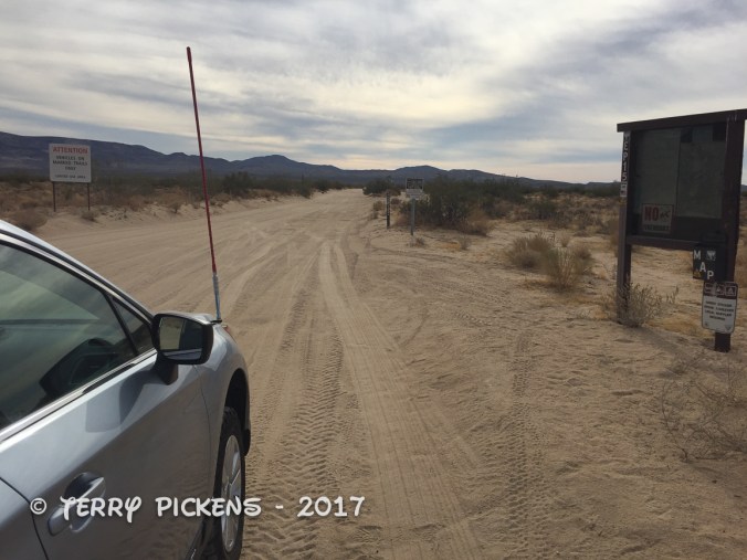
Hart Road
The naturally occurring scouring powder used in Old Dutch Cleanser which is a household cleaner known throughout the U.S. This mine produced about 120,000 tons of the white pumice from 1923 – 1947. The wide drifts (mine tunnels) are up to 21 feet in height. The side-by-side tunnels are still completely intact. In 1947 the manufacturers started obtaining pumicite from other sources thus ending production at this location. The mine is open to exploration but be careful, the tunnels are at steep angels and the ground still has a very fine powdery surface layer. This was a fun place to explore but as I was alone I did not venture too deep into the mine. You cannot see the ends as they are very dark but I understand there are some several hundred feet long.


After my visit was completed I backtracked to Hart Rd and continued east to explore another talc mine.

This location had a water trough, stone remains of a building (?), some mining equipment and several short large tunnels in the hillside. In one tunnel I notice a large Dining Room size rock had fallen from the ceiling. I do not know when this large piece of ceiling fell in, but this is why you need to be very careful in these long deserted mines.

Talc MIne


Further along EP-15 I turned off Hart Rd and was now on the Bonanza Trail. This was the path the gold seekers used to the mines in the sierras then upon returning tried find their fortunes here. The area was so populated that a post office was established in the 1930’s to serve the miners in the area.


The Bonanza Trail turns south just after the Post Office into Bonanza Gulch. At this turn you can head north to find some additional mining operations not far from this intersection.
In Bonanza Gulch you pass 2 of the old cabins that are available on a first come first serve basis. I did not know of this program at the time and saw the cabins looked in good condition so I stayed away thinking these might be private property, so check first on locations of these adopted cabins to make sure you do not roll up to someone’s residence and an unexpected surprise.
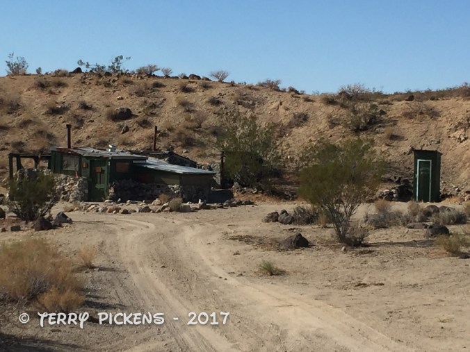
Adopt a Cabin

Which way to go?
It was a fun drive through the gulch and I turned to stop at Bickel Camp, a short side trip off EP-15, to see the mining equipment on display there. Bickel Camp and its cabin is a historic 1930’s era mining camp. Sadly it was closed on this midweek visit so I just enjoyed the view from the fence line.


Early miners were attracted by gold-bearing river channels that contained exposed surface gold. Walt Bickel prospected, and came to stay in the early 1930s. 1986 saw the BLM embarked on an effort to remove “squatters” and remove all “potential drug lab” cabins from public land. Public opinion was effective in having Walt’s cabin and artifacts kept onsite at the time, but not before Walt suffered a mild stroke and had to be hospitalized and in a rest home up to his death in 1996. The camp was watched over starting in the mid-1960’s by Walt’s son-in-law, Larry O’Neil. Larry helped keep the mining claim active and was effective in watching over the camp and its contents up to June of 2004, when he moved to his family in Hesperia.
The camp is still there to be visited by the adventurist explorer. Luckily this has remained on the “Adopt-A-Cabin” program and there is a caretaker on site to help explain and protect the remaining historic artifacts. Donations to help preserve and maintain the site are appreciated.
Vandalism has happened at the site, but Bickel Camp has not suffered the same fate as Burro Schmidt’s cabin. Since not having a caretaker from 2004 the cabin has been stripped bare of articles and is now fenced off. The visitor at Bickel camp sees plenty of history in a unique setting; mixing geology, nature and an individual’s creative technology. Please be respectful of this site and hopefully we can help sustain this for future generations to enjoy.
High atop a mountain above Last Chance Canyon, is a place to see one man’s determination. Named Burro Schmidt’s Tunnel, WIlliam Henry “Burro” Schmidt hand-drilled a tunnel nearly a half-mile long with a single 4-pound jackhammer, and dynamite.


Schmidt didn’t stop to explore any of the veins of minerals he encountered, he continued his mission, to provide easy transportation to the railroad for his ore as no roads to the other side of the valley and railroad existed at the time. He was 36 years old when he started his tunnel, and 68 when he finished. He took out 20 tons of ore averaging $60 a ton in gold, silver, copper, iron, molybdenum and tungsten. The digging and hauling was completely by hand, filling and pushing the ore cart by himself. His track leveling method was only a bowl of water placed on the track, and the tunnel is dug dead straight for two thousand feet, with a only turn at the end before the exiting the other side of the mountain.

Burro Schmidt Cabin
Living in a small one-room cabin with newspaper and magazine clippings on the walls for insulation he cooked his meals on a small wood fired stove which also warmed the cabin in winter. Schmidt was entered into “Ripley’s Believe it or Not” as the “human mole” and the tunnel is listed on the list of Historic Sites and is a popular attraction in the area. Huell Howser even did a segment on this man and his tunnel in 1994.
Leaving Burro Schmidt’s Tunnel I continued east on EP-15 to the intersection with EP-100.

Heading out down Mesquite Canyon
Turning south I exited the El Paso Mountains down Mesquite Canyon to the paved Randsburg Red Rock Road to stop at the small, still populated, mining community of Randsburg then continue on US Highway 395 south toward home.
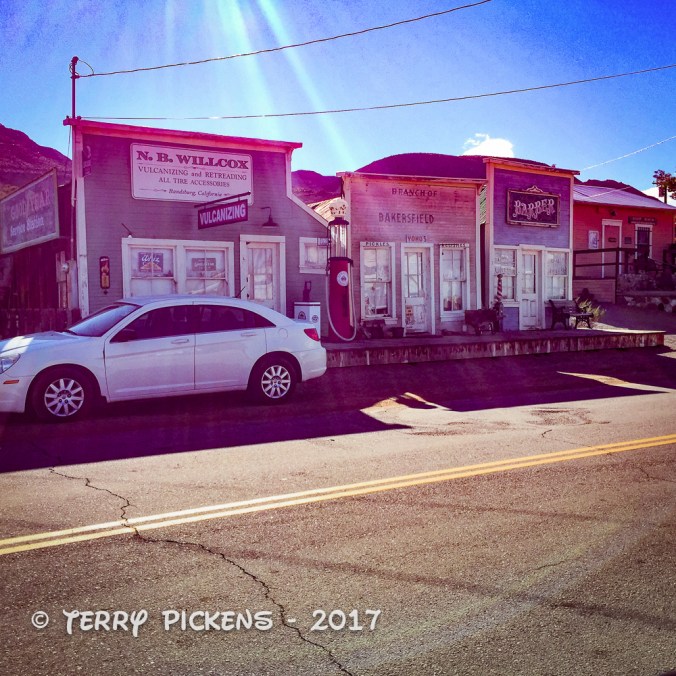
Randsburg, CA

Pingback: January 27,2018 Bickel Camp Fundraiser | TVP Journeys
Love the call out to the rock formations and fault zone alongside the highway.
LikeLiked by 1 person
I can’t believe that fellow Schmidt dug the tunnel all by himself – an amazing feat!
LikeLiked by 1 person
He was quite a determined individual.
LikeLike
Oops *are*
LikeLiked by 1 person
There amazing spaces I’ve never seen them before Terry and yes this is an educative post 🤓 you had fun creating it I’d say 😀 fun!
LikeLiked by 1 person
Yes I did Hedy, had fun out there and writing this post. Just wish I had investigated some of this before the adventure, would have looked at things with a totally different mind set.
LikeLike
Very nice post! Sounds like fun. I love the history and videos you included! ❤
LikeLiked by 1 person
Thank you so much Samantha
LikeLike