Day 4 – Onward to Fort Nelson and Beyond

Waking up the next morning there was a light rain dropping on the tent. Packing up quickly and having a quick breakfast we cross the Kiskatinaw Bridge and link back up with the Alaska Highway a little further north from where we left it last night.

Here are some sights that are located along the drive today. Medium to heavy rain meant we continued on praying that it would stop for the evening camping.

H. Maclean Rotary RV Park at Charlie Lake has a memorial for 12 soldiers that drowned in May of 1942 when their pontoon boat sank transporting equipment to the job site on the opposite bank of the river.

The treacherous Suicide Hill was a grade that welcomed travelers with a signpost reading “PREPARE TO MEET THY MAKER”. Guess you had to have a sense of humor if you were traveling up here in the early years. The Highway now bypasses this hill.

330ed5e06ffb22bde3e0e74dc0f2d42b--us-army-soldier-alaska-highway

Suicide Hill

Sikanni Chief River Bridge was the first permanent structure completed along the highway. Built by African American army engineers it was destroyed by an arson fire in 1992. Only the original pilings are remaining.

The southern end of the Trutch Mountain Bypass is at Historic Milepost 191. This section of the Highway was bypassed in 1987 with a new road eliminating a steep mountainous winding drive. The original roadbed is a gravel road still in use by gas and oil patch crews.

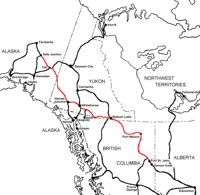
Fort Nelson 283 miles (454.3 km) north of Dawson Creek is another town offering lodging, services, campgrounds and a few attractions. Originally based on the fur trade, the town was built in 1865 along the Fort Nelson River’s west bank after the second town was destroyed by fire after the local aboriginals killed the 8 inhabitants in 1813. A upward growing population in the 1940’s and 1950’s got the town recognized as an Improvement District in 1957 and finally a village status in 1987. Mile zero to clearing crews of the AL-CAN, this town is where the first clearing crews started work along the AL-CAN as a winter road already existed between Dawson Creek and Fort Nelson.

Arriving in Fort Nelson it was still raining pretty good so went into the Visitor Center for a break from the drive and to discuss the plans for the night. This is a very nice Visitor Center with a great information desk, a souvenir shop, visitor information brochures, a short movie on the area and a large sitting area for resting. Going onto WiFi it was shown by weather apps that the rain will not subside anytime soon and is scheduled to be pretty heavy at times.

Searching the road ahead it was determined to try and get a place to stay along Muncho Lake at The Northern Rockies Lodge. This is a nice lodge but a little expensive. Oh well, this might be the last time for a room and shower for awhile and the rain was coming down pretty good.

Asking the information desk on a nice place to have a late lunch it was recommended to try a restaurant just down the street. The Gourmet Girl is a small establishment that serves very good food in a quaint atmosphere.

Veering west for 200 miles (322 km) the Highway enters a dense forested area with distant wilderness vistas of 100 miles (161 km) or more.

Gardner Creek is named for local trapper Archie Gardner who helped recon this part of the AL-CAN. He is remembered in Earl Browns book “Alcan Trailblazers” by Harry Spiegal as “An old trapper….who has lived up here all his life, is the wrangler and is in charge of the string. He wears homemade moose-hide beaded moccasins; Kentucky-jean pants [and] a big beaten slouch hat. A hank of grey hair protrudes from his old hat and half covers his eyes. He sports a half growth of stubby grey whiskers and smokes a crooked, big bowl, sweet smelling pipe…..Archie is 62 years old and even though quite thin and weather beaten, he is as straight as a spruce tree and as nimble as a boy in his teens…..Archie knows this country like a book and I’m sure his knowledge of this terrain is going to be very helpful for our work.”

A required stop along the Highway is Testa River Lodge, Services and Campground for some world famous cinnamon buns. This is a very nice location with small souvenir shop, campground with showers and laundry, and a nice outside covered sitting area to rest.

At Historic Milepost 392 is the highest pass on the highway at 4,250-feet (1,295 m).

Another reroute of the original Highway is at Muncho Lake. The original highway is far above the lake on the mountaintop and required considerable excavation by the crews. It was relocated to a benched terrace right above the lake; hikers and mountain bikers now use the original road.

7-24 Rainy Day-1

Arriving at the nights destination, Northern Rockies Lodge, it is a lovely place. This historic highway lodge is open year round providing accommodations, a full service restaurant, gas, seasonal camping and a flying service.

ALASKAN HIGHWAY (THE AL-CAN)

800px-Alaska_Highway1

A road that was proposed for years became a military necessity due to the attack on Pearl Harbor. It is a road that has been dubbed “a significant feat of time critical engineering and construction” by The American Society of Civil Engineers. In 1995 it was awarded the Historic Civil Engineering Landmark Status” and is a 20th century engineering achievement.

Viewed with by congress as an urgent matte,  it was February 11, 1942 that a Special Committee and President Roosevelt authorized the construction of a joint United States/Canadian effort to build the road north. During it’s construction the Japanese also invaded Attu and Kiska Islands in the Pacific adding to the urgency to protect this state of America and the Pacific shipping lanes.

Even though it was only a dirt/gravel path through the wilderness during the war this historic road was needed as a vital military route to provide supplies, troops and equipment safely to Alaska. An engineering feat to get this 1,390 mile (2,237 km) road completed in such a short amount of time, not just because of it’s length but also for the terrain and environmental restrictions placed by the regions it traversed; then finally that Canada was deeded the access road after the war to gain access into it’s remote northwestern region that was difficult to access at the time.

Construction of the AL/CAN (Alaska-Canadian Highway) officially began on March 9, 1942 with a mobilization of men from the United States. Work along the route was to be provided by American troops and individuals. The Canadian Government provided the right of way through Canada, waived import duties, sales tax, income tax, immigration and provided construction materials along the route. After the war the portion of the highway in Canada was to be turned over to the Canadian Government. America would provide all the manpower and equipment to build this road through the wilderness.

During construction there were numerous rivers to cross. At the time of original construction there were a total of 133 bridges along its route, 64 were more than 100 feet (30.5 m) in length. Pontoon bridges were first constructed to continue work on the road while a timber truss or timber trestle bridge was being constructed. These timber bridges were no match for the winters and the water flows of these untamed waters, so 99 of the 133 bridges were replaced with steel truss bridges, steel I-beam bridges, plate girder bridges, suspension bridges, and reinforced concrete bridges.

More than 10,000 American troops poured into Canada to locate, survey and construct this path north. No formal roads existed north of Dawson Creek, B.C. so the army was instructed to push north from that railhead.

Following winter roads, summer pack trails and winter trap lines a route was surveyed by using local information about the makeup of the topography. With skimpy rations and harsh conditions these individuals completed the road on October 25, 1942 just 8 months and 12 days after the start of construction. Finally opened to the public in 1948 it is one of the iconic adventure road trips for many people.


Day 3 – To Dawson Creek

It was a short drive to Dawson Creek, B.C. from the campsite.

Along this section of Highway 97 is the Town of Chetwynd with its chainsaw carving project that began as part of the 50th anniversary of the construction of the Alaska (Alcan) highway. Located along the main roadway and at the Visitor Center these carved chainsaw statues are something to admire and are exquisite as you pass through.

Chetwynd_from Google

The Alaskan Highway formally starts in Dawson Creek, BC at Mile Marker 0. The 1,422-mile (2,288.5 km) long formal Alaskan Highway ends in Delta Junction, AK while the unofficial end is in Fairbanks, AK, 1,523 miles (2,451 km) from Dawson Creek, BC.

Alaska-Highway-Map

Dawson Creek was incorporated as a city in 1958 and is a principal railhead of the British Columbia Railway and the intersection of 4 major highways in the area. Make sure to get your photo at Milepost 0 Cairn, visit the Pioneer Village, Dawson Creek Art Gallery and the Alaska Highway House to name a few of the sites in town. And if you have time visit the Northern Alberta Railways Park.

We saw the Mile Zero Cairn / Sign Post for a photo op, the Surveyor Statue, visited the Alaska Highway House Museum, walked the couple of blocks to see the Official Zero-mile Post a few blocks away and had a nice lunch at Hug a Mug’s Coffee House and Eatery.

It is sad the original, official mile post mark was a part of countless pranks and kidnappings with this new one replacing it in the 1980’s.

ACX-ACP90184 - © - Ron Erwin

Driving 20 minutes north of town, the stop for the night was at the Kiskatinaw Provincial Park. This campsite is located right next to the curved, wooden Historic Kiskatinaw Bridge. Kiskatinaw means “cutback” in Cree. Constructed in 1942-43 by the US Public Roads Administration it replaced an original 3 span timber trestle. With a 9 degree curve to accommodate the Steep grade change and the need to notch a cliff at the east end. It was one of 133 permanent bridges built to replace the temporary bridges built by the U.S Army. At about 122m (400 foot) long it was the first curved bridge to be constructed in Canada and one of the last in North America to remain.


Day 2 – Onward toward Dawson Creek and the Alaskan Highway

After waking up and eating a good breakfast we continue north on Canada Hwy 97 and take a side loop road to Chasm Ecological Reserve. This canyon was carved by a stream 10,000 years ago at the close of the Ice Age. You can see the layers of lava in the walls of the chasm.

Along this section of Highway there are Mile Houses. These were so named because they are located that many miles from Lillooet (Mile 0) of the Cariboo Wagon Road. As the gold rush subsided, ranchers began to settle the surrounding areas and the towns held onto those names.

At the town of 100 Mile House, the worlds largest pair of cross country skis, as stated by the plaque in front, stand in front of the Visitors Center. 100 Mile House’s origins as a settlement go back to when Thomas Miller owned a collection of buildings serving as a resting point for the traffic of gold seekers moving north to the gold fields.  It acquired its name during the Cariboo Gold Rush when a roadhouse was constructed in 1862 at the 100 mile (160 km) mark up the Cariboo Wagon Road from Lillooet.

Giant Skis

And the first revision to the trip, it was decided to not stop at Barkerville and continue north. Barkerville shall be saved for a future adventure.

After passing through the large town of Prince George it was time to visit another site just off the highway, The Huble Homestead Historical Park.

Getting there right before to closing we had about a 1/2 hour to hurriedly walk through the Farmhouse, and Barn before looking around at the farm equipment in the fields surrounding the homestead. The farmhouse is a typical Ontario Farmhouse that took nearly a year to complete. Mr Huble later relocated and connected the old smaller family cabin to the side of the house to be used as summer kitchen. The house consists of a parlor, dining room, an office, a first floor master bedroom, and four upstairs bedrooms.

A barn, equipment shed and several small individual workers cabins surround the homestead.

Al Huble and Edward Seebach partnered to set up a business selling goods to trappers in the area and people passing through. After 10 years the business became so successful they built a false front General Store facing the river, painting it white to draw attention to it. This building, relocated closer to the Homestead Historical Park, served local land owners, travelers on the Fraser River and construction crews for the new Grand Trunk Pacific Railroad.

Homestead 12

Continuing the northward trek, the nights campsite was at Crooked River Provincial Park along side Bear Lake. After setting up camp and having a quick bite to eat it was time for a stroll down along the lake shore to again be witness to a beautiful sunset.

Day 1 – The first push from Vancouver, WA

Planning this adventure has been a 2 year ambition of mine. Last year life got in the way of the trip so this year it was a go. I got some interest from a few people that would like to tag along and one did show up at my house the day before departure.

Leaving early to get through the Sunday morning Seattle traffic the first stop will be the border crossing into Canada. After an easy crossing at the border we headed toward Abbotsford, British Columbia  going north on BC 11 to Canadian Hwy 1.

The first section of the journey follows Canada Hwy 1 and the Frasier River. A 20-mile section of this road also includes 7 tunnels you must pass through.

Stopping at Hells Gate we elect to walk the 35 minutes down into the canyon instead of taking the Aerial Tram (Gondola). This abrupt narrowing of the river is located just downstream of Boston Bar. The rock walls of the river plunge toward each other forcing the waters through a passage only 35 meters (115 ft) wide.

The narrow passage has been a fishing ground for Local Native communities in the area for centuries. European settlers began to congregate there in the summer months to fish. This canyon became a route used by fortune seekers of Gold Rush miners accessing the upper Fraser gold-bearing bars and the upper country beyond. It was a dangerous passage where canoes didn’t dare its rapids. Ladders and shelf roads were constructed to get around its treacherous waters. Only one Sternwheeler successfully manuvered through this section of the canyon.

Continuing on Canadian 1 for a short time we decided to stop at Goldpan Provincial Park for the night. Finding a campsite along the river makes for an ideal location for the nights camp. After eating dinner it’s a short walk to the water to sit on the back with feet in the cool water and watch the sun set behind the mountain.

And this is what was heard in the tents all night long, what a sweet background noise to lull you into slumber.

Beacon Rock along the Columbia River

I heard of this climb in a magazine promoting hiking trails surrounding Vancouver, WA. I decided to climb the up the short 1.8 mile (2.9 k) round trip to the top of this rock when the weather got better. At only 700 foot (213 m) elevation gain this may seem like an easy hike, but don’t fool yourself it’s a 700 foot (213 m) climb in only 0.9 mile (1.45 k) involving many switchbacks, steep grades, and stairs the entire distance. Who needs a gym with a stair master when you can go out here.

IMG_0506

A prominent and distinctive geological feature along the Columbia River Gorge, this 848-foot (258.5 m) high landmark was the core of a volcano 57,000 years ago. The rock that remains is the lava core that was not washed away by the massive force of ice-age flooding. During the last Ice Age an ice dam formed in Idaho creating an enormous lake behind a 1/2 mile (804.5 m) thick block of ice.

This ice dam failed numerous times sending an enormous amount of water down through the Columbia River Gorge flowing at 60 mph (96.5 k/hr) up to 600 feet (182.9 m) deep. The city of Portland, OR could have been 400 feet (121.9 m) under water during these floods. This amount of water caused erosion created the hanging valleys and waterfalls that are prevalent along the river right now.

The trail built by Henry Biddle between 1915 and 1918 is one of the oldest trails in the area. At the time Biddle built the trail with handrails and bridges to the top for people to visit. His family later donated the land to the Washington State Parks in 1935.

An important landmark along the Columbia River this rock served as a landmark to local tribes denoting the last of the rapids of the great river. Originally named “Beaten Rock” by Lewis & Clark in their journals on the Voyage of Discovery in 1805, it was renamed on the  return journey “Beacon Rock” for unknown reasons.

This slideshow requires JavaScript.

“The entire trail is a near-continuous series of switchbacks, many of them less than 20 feet long and the trail loops over itself at least twice. I counted 52 switchbacks, while one of my sons counted 54 and the other came up with 49. That says less bad about our educational system than it does good about the distracting views. The trail is completely lined by handrails and is safe for all but the tiniest walkers.

Most of the trail is up the open, west side of the rock, providing views down the river of Angel’s Rest and Cape Horn. With little shade or water, this part of the trail can be really hot in the summertime. Beacon Rock actually has two summits and the trail works around the south one and proceeds up the east side toward the higher, north summit. The trail is forested here, but the terrain is still rocky enough to provide great views of Hamilton Mountain and the river toward Bonneville Dam. At the summit, a few quite large stairs lead to the summit pinnacle. Here, trees block a bit of the view, but it’s certainly worth seeing.

The wind is usually howling on one side of the rock and dead calm on the other side, creating a dramatic difference in the perceived temperature. You’ll need a jacket most days, but you’ll carry it a lot.” – OregonHikers.org

Morning walk around downtown Vancouver, WA

Well I’ve been very negligent in posting here for a long time. I must get back on the horse and start posting again. So here goes, I took another morning walk, this time around Fort Vancouver National Historic Site and downtown Vancouver, WA.

It started off as a foggy day at home so I decided to head down to the Columbia River to get some bridge photos of the Interstate 5 link between Portland and Vancouver. Guess I didn’t get up early enough as when I got down there and walked to the bridge the fog had lifted. Still an overcast day I decided to capture some photos of the bridge and continue my walk into downtown and find some interesting buildings to shoot.

Upon finishing in downtown I walked back to Fort Vancouver NHS and took some photos of the flowering trees that are prevalent right now here in the Pacific Northwest.

Heading home I opened the photos in Lightroom and started playing with filters and presets. Here are the results. Hope you enjoy.

Bridge at Columbia River

Downtown

The Academy was established in 1856 to meet the spiritual, social, educational and healthcare needs of this frontier region starting in a small wooden cabin near Old Fort Vancouver (Vancouver Stockade). This campus moved to it’s current location and dedicated in 1873. This site has served as a school, orphanage, religious headquarters and is still in use today as a multi-use commercial center and City landmark.

DowntownVancouver, WA-13

The Academy

Trees at Fort Vancouver NHS

Alabama Hills, Lone Pine, CA

I had just an evening and a few hours the next morning to explore the Alabama Hills. I got in after dark and it was very windy and cold Halloween night so I didn’t want to spend too much time outside. I shall return with more time to explore the Movie Road and Movie Flats to find the locations of the arches and television / movie shooting locations. The Museum of Western Film History in Lone Pine will provide a history and has information and self-guided tours of the area.

Alabama-Hills-Movie-Location-Map

Map of several of the Alabama Hills movie sites

These hills, arches and rock formations on the eastern slope of the Sierra Nevada are in the shadow of Mount Whitney just west of the California town of Lone Pine. Located right off the road to Whitney Portal, the starting point for climbing the 11th highest peak in the United States and the tallest in California, this BLM land is open for exploring, hiking, astronomy, camping and exploring. The formations are part of the same geological formation although geographically separate from the Sierra Nevada Mountains just adjacent to the east

Mines in the area were named after the Confederate Civil War ship the CSS Alabama by sympathetic confederate miners of the time and then it became the name of the entire area. When the Alabama was finally sunk by the USS Kearsarge in 1864 the mining district, a mountain pass and peak and a town were named Kearsarge by sympathetic union miners.

Used by television and movie productions for filming, especially Westerns. Since the 1920’s this rugged environment has been shown in approximately 150 movies and a dozen television shows. A few of the early television shows have been Tom Mix, Hopalong Cassidy, The Gene Audrey Show, The Lone Ranger, and Bonanza. While Gunga Din, The Walking Hills, Yellow Sky, Springfield Rifle, The Violent Men, Bad Day at Black Rock and How the West was Won are some of the Movie Classics. Current Films have included Gladiator, Django Unchained, Iron Man, Man of Steel, Firefly and Tremors.

Nighttime is just as impressive as the landscape during the day as the Alabama Hills is a Bortle Class 2 “average dark sky” site. On a clear moonless night many star formations and the Milky Way appear brightly in the night sky.

My visit to Lassen Volcanic National Park on a trip south to visit family.

Lassen_Volcanic_National_Park_map

I left Vancouver for southern California and my first overnight stop was Lassen Volcanic National Park in northern California. As the name implies it’s major features are volcanic in origin. Being the southern most volcano of the Cascade Range the prominent features of the park are the largest plug volcano in the world, Lassen Peak and it’s sulfur – thermal hot springs.

7-2


Originally two separate National Monuments dedicated in 1907 by Theodore Roosevelt, Cinder Cone and Lassen Peak National Monuments were declared Lassen Volcanic National Park in 1916.

0-0

I arrived late in the afternoon after an 8 1/2 hour drive and set up camp at Manzanita Lake Campground located in the northern section of the park. Then I proceeded to walk the loop trail around Manzanita Lake, ate dinner and enjoyed a nice campfire before retiring to my tent to read and fall asleep.


Accessible by five vehicle entrances the majority of visitors enter either from the north or south along State Route 89, named the Volcanic Legacy Scenic Byway or Lassen Volcanic National Park Highway, off State route 44 in the north and 89 from the south. Three unpaved roads enter the park but do not connect with the main road through the park, Highway 89.

The north-south 29-mile (46.6k) road, Highway 89, was constructed between 1925 and 1931. The road summit is the highest in the Cascades topping at 8,512 feet (2,594 m). This road is closed in the winter months due to snow, which can reach 40 feet (12.2m) deep.

0-4

Early morning along the Lassen Volcanic National Park Highway


I got up early, had a quick breakfast and packed up to head south along Route 89 to visit the sites of the park. It was very interesting stopping at the many informative signs along the road to read the history of the park.


The last minor to major eruption started in 1914 and lasted until 1921 creating a new crater on Lassen Peak. Releasing ash and lava it fortunately did not kill anyone. This eruption covered many miles of forestlands with landslides and the new growth forest today stands many feet above the old forest floor. These landslides also created Manzanita Lake as it damned Manzanita Creek.

The first blast was on May 19, 1915 and was said to be a night to remember with it’s steam explosion and subsequent mudflows. Had it not been for Elmer Sorahan many people might have died but he ran 3 miles (4.8k) to warn others after escaping the explosion.


Three days later on May 22, 1915 another explosion on Lassen Peak threw ash, pumice, rock and gas into the air that was more devastating to the area than the first. The pressure in the mountain built up like a lid on a boiling pot of water and finally blew. You can now explore this area on a ½ mile (0.8k) loop trail or take the strenuous 2,000 foot (609.6m) 5 mile (8k) round trip hike to the top of 10,457 foot (3,187m) Lassen Peak. Many other hiking opportunities exist in the park along with backpacking, auto-touring, bird watching, camping skiing, skiing, snow play, and snowshoeing.

There are 5 hydrothermal areas to explore within the park. Sulphur Works, Bumpass Hell, Devils Kitchen, Boiling Springs Lake and Thermal Geyser. I am limiting myself to 2 for this trip.

4-4

My first hydrothermal area would have been the hike out to Bumpass Hell Hydrothermal Area, a moderate 3 mile (4.8k) round trip hike. This is the largest hydrothermal area of the park with temperatures of up to 322 degrees F (161 degrees C). I had done this hike with my kids back in the early 1990’s although I found the trail closed this season for maintenance of the trail and boardwalk through the 2018 season.

My next stop was Sulphur Works, a formation of mudpots, steam vents and boiling springs located right off the main road. This hydrothermal area in near the center of a massive composite volcano that collapsed many thousands of years ago. Mount Tehama or Brokeoff Mountain was estimated to be 1,000 feet (304m) higher than Lassen Peak. Active 400,000 to 600,000 years ago it is estimated to be nearly 11 miles (17.7k) across and had towered to 11,500 feet (3,505k).


My final stop was the Kohm Yah-mah-nee Visitor Center at the south entry of the park to visit the small museum learning the history of the park, peoples and area and had a nice talk with the Rangers.

Now for the long 8 hour drive down the east side of the Sierra Nevada Mountains along State highway 395 to the BLM area of Alabama Hills outside of Lone Pine, CA.

Fort Stevens and Ecola State Parks, Oregon

After a restful nights sleep I make a small breakfast, pack up and head out for the short 1-hour drive across the Columbia River into Oregon for a visit to Fort Stevens State Park. Located in the far northwest tip of the state this park is bordered on 1 side by the mouth of the Columbia River and on  second side by the Graveyard of the Pacific This 4,300 acre (17.4 sq km) park has much to offer to its visitors; walk or drive along the beach, hike coastal and forested paths, bicycle along bike trails, camp, beachcomb, birdwatch, visit a shipwreck, explore an abandoned military installation used during the Civil War and World War II. Or just relax and enjoy the area.

Fort Stevens Park Map

My first stop was to see one of the shipwrecks along this stretch of the Graveyard of the Pacific. Along with approximately 2,000 other ships since 1792, the remains of the Peter Iredale now rests on the sandy beach. Only a portion of this 275 foot (83.8 m) long steel ship remains, grounded where she came to rest in 1906 from a navigation error in dense fog by its Captain due to the areas treacherous weather and storms. It has become an attraction since the day it grounded on the sandbar.


Next stop was Fort Stevens. First built in 1863-64 during the Civil War it was in use up until the end of World War II, it was part of a 3-fort system at the mouth of the Columbia River to defend this waterway and ports from attack by sea. The other 2 forts were located in the state of Washington; Fort Canby at Cape Disappointment and Fort Columbia a few miles up river from Fort Canby. (For my visit to Fort Canby and Cape Disappointment see LINK)

Day 2-26

Fort Stevens installation map


During World War II a Japanese submarine fired upon Fort Stevens in June of 1942, making this fort notable as being the only military base on the Continental United States to be fired upon by an enemy since the War of 1812. 17 rounds were fired at the fort with no real damage being done.

After a full morning of exploring the buildings and small Fort Stevens Visitors Center – Museum I enjoyed a late picnic lunch and continued my journey south on Highway 101 to visit Ecola State Park. This 9 mile (14.5 k) long stretch of beach lets you enjoy hiking, picnicking, tidepooling, surfing and scenic coastal vistas. Located just north of Cannon Beach, OR I leave Highway 101 and travel the13 miles (21 k) of twisty narrow roadway into the north area of the park to see Indian Beach Day Use Area. This secluded beach is a spot frequented by surfers, beachcombers, and tidepool explorers and is reached along a short path down the hillside to the beach. Extending north is a network of trails that will provide a 2 ½ mile (4 k) loop trail to the top of Bald Mountain or continue north to Tillamook Head trailhead which is part of the Oregon Coast Trail. The loop trail is part of the Lewis and Clark National Historic Tail, walked by Lewis Clark and a band of men from the Corps of Discovery to search for a beached whale in 1806. They were hoping to return to Fort Clatsop with whale blubber as they fought hunger from their time there. They sadly return empty handed.

Day 2 Ecola State Park Map


After this beautiful day of exploring I returned to my car and drove the 2 hours back to my home to plan the next trip in a few weeks, south to visit my family and friends at the home I just moved from.